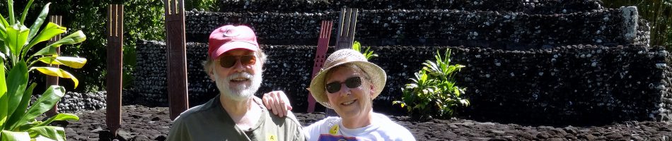
Colombo, Sri Lanka — 2024
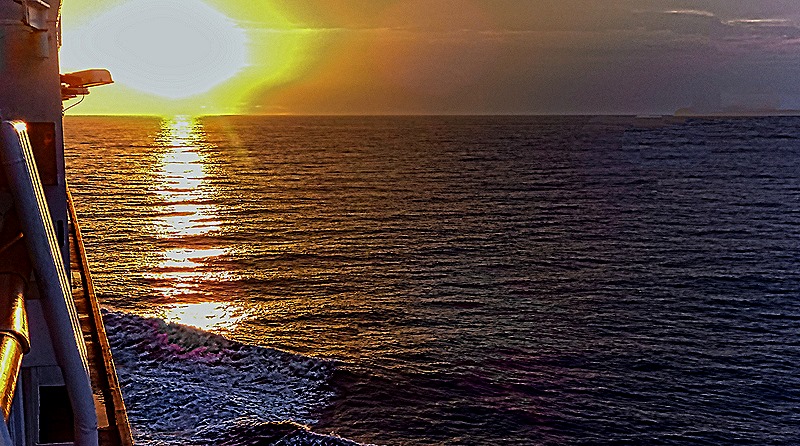
We reached Colombo on the morning of March 28. The previous evening we had a very bright sunset.

Before independence Sri Lanka was for a long time a British colony called Ceylon. It is an island nation off the southern coast of India. We have been here twice before, walking a long distance around the city in 2016 then visiting the city of Galle in 2018, so if you want to read background information and/or see a lot more pictures you can do so here:
2016: https://baderjournal.com/2016/05/07/colombo-sri-lanka/
2018: https://baderjournal.com/2018/08/06/colombo-sri-lanka-2/
For this visit we booked an excursion with our travel agency that would take us to some places in Colombo we hadn’t seen (and passing by a few we had seen before). As on our previous visits there was a colorful troop of dancers and musicians (mostly drummers) to greet us on the dock. We watched them from our veranda, then again when we left the ship to start our excursion.


We left early in the morning after the ship had been cleared by the local authorities. The harbor facilities were much more extensive than the last time we were here 6 years ago and a lot of construction activity was still under way. In the past we had docked fairly near the port exit (close enough to walk), but we were docked much further away from town this time. So the bus trip was surprisingly long just to get to the port exit.
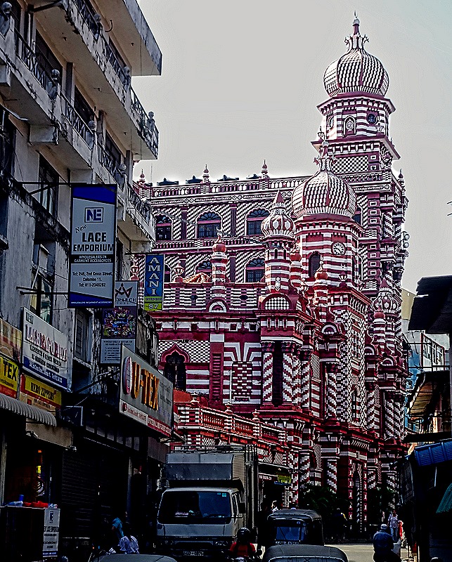
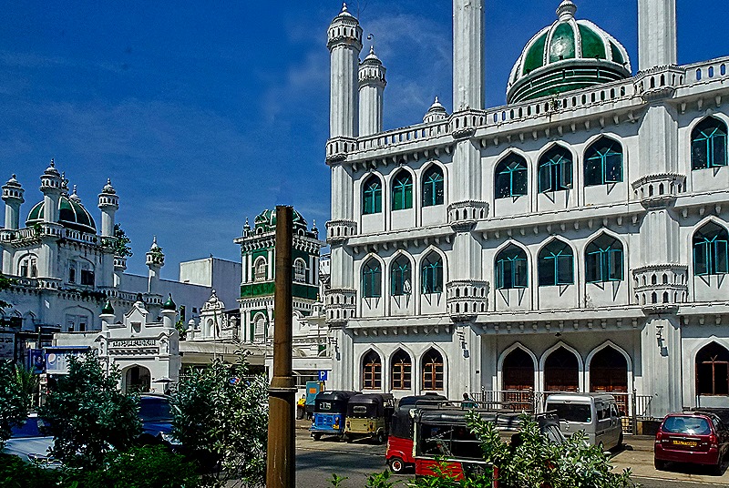
On the way to our first stop through the streets of Colombo, we passed several notable landmarks (shown here in no particular order). First was the Jami-Ul-Alfar Mosque, an unmissable large red and white candy striped building not far from the port. It opened in 1909 and was expanded in 1975.


We drove past both of the old lighthouses of Colombo. The Colombo Clock Tower was built in 1857. It was the tallest building in Colombo at the time and the light from an old wooden tower was moved to its roof in 1867. As time passed taller buildings nearer the ocean front obstructed the light and it was decommissioned in 1952. The light was moved to a new 95 foot tall lighthouse built just outside the port. It is painted black and white on the ocean side but is plain stone on the land side, as you can see in the picture below (and note the lions at the base of the tower). We also drove past the Australia Building, which dates to 1900 and sports a distinctive Victorian facade with stripes of red and white brick.


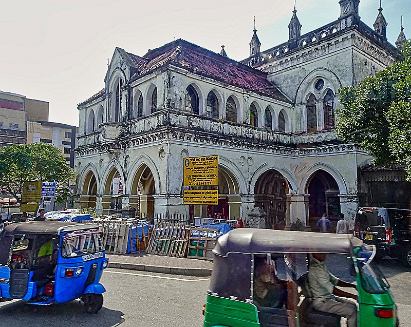
We passed through several busy intersections in this bustling city and we saw both the original old town hall and the current town hall. The old town hall was built in 1873, the first government building in Colombo. The governmental operations were moved in 1925 to the new town hall and the old one fell into disrepair until it was renovated as a museum in the 1980’s. You can tell from looking at it that the gleaming white new town hall was modeled on the US Capitol in Washington, on a smaller scale.


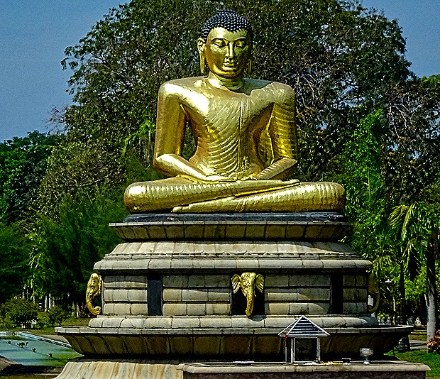
Near the current town hall were two other landmarks. The Dewatagaha Mosque, built in 1820, contains the remains of a Muslim saint. We think this is a picture of this mosque, but we have been unable to find another picture of it with green paint highlights, so the green may be very new. We also saw a very large golden sitting Buddha at the entrance to Vihara Maha Devi Park. Before the 1950’s this was called Victoria Park and we understand there was a statue of Queen Victoria here.


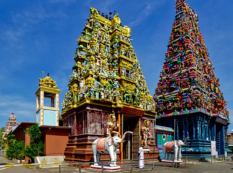
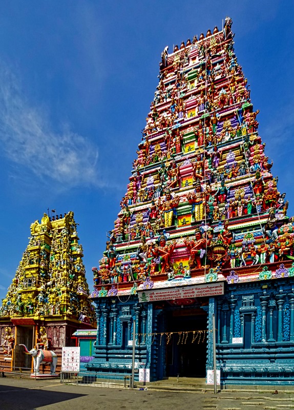
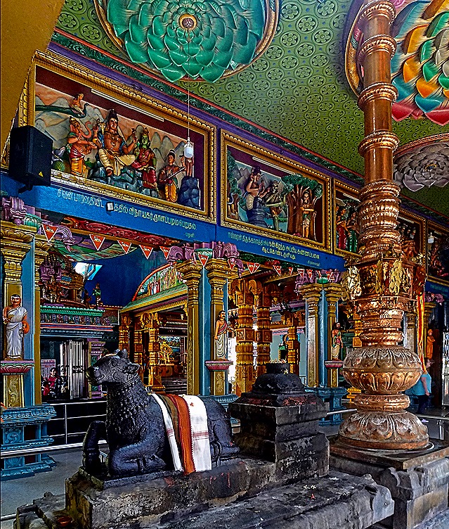
Our first visit of the day was to Sri Kailawasanathan Swami Devasthanam Kovil, a Hindu temple complex. Said to be the oldest Hindu temples in Sri Lanka, construction began in 1783. The two main temples connected by a pass through are dedicated to Shiva and Ganesa (aka Ganesh), and there are smaller shrines to other deities on the grounds as well. Like the other Hindu temples we have visited, the front has a tall roof over the entrance that is covered with colorful sculptures of Hindu deities.

 approaching the entrance to the larger temple")


The rooms inside and the passageway were really very colorful, including the ceilings (always look up). We can’t identify many of the items in these pictures, but the elephant god is certainly Ganesa.


From these temples we could see the Lotus Tower; indeed at 1150 feet tall you can see this from many parts of town. This tower, which also can be seen from the port, was under construction during our first two visits. It was completed in 2019, financed by China we have been told. Its design is based on the Lotus flower bud, a symbol of purity in Sri Lanka.


We drove past the Independence Memorial Hall in Independence Square. This is the spot where the first elected parliament convened on February 4, 1948 to mark the independence of the country. The Memorial Hall was later built to commemorate that day. We did not stop here but drove by it, leaving us with hurried pictures of the Hall and some of the stone lions that surround it. In a park nearby we saw a large standing Buddha sculpture.


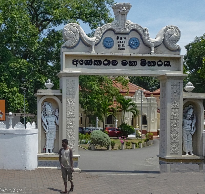
Our next stop was to visit the Asokaramaya Buddhist Temple, built in the 1870’s and expanded several times since. It is fairly plain on the outside, painted mostly white or muted yellow with none of the riot of color of the Hindu temples we saw this morning. But the inside is full of colorful statues of Buddha and other deities with well regarded Buddhist paintings on the wall, mostly about the life of Buddha.


 on an elephant, above the door in the first picture")
")


Outside in a rear courtyard of the temple is a Bo tree, rising from a low protective structure ringed with small Buddhas in niches. This species of ficus is the type of tree under which the Buddha sat when he attained nirvana. There are several stupas on the temple grounds that are said to contain relics meaningful to this temple, and we saw a delightful low wall shaped into a row of elephants. On the street outside we saw tuk-tuks, three wheeled vehicles used as taxis. Their drivers can be very aggressive in trying to recruit you for a tour; on past visits we have been followed down streets quite a way before they gave up.


The National Museum of Sri Lanka opened in 1877. Today it has more than 100,000 artifacts and branches in nine other cities. As usual, we didn’t have enough time to really get to know and understand the museum, but we wandered through a number of galleries on its first floor that were crowded with antiquities. In fact, it was so crowded with display cases that the two of us lost each other for a while & it took some time to find each other again. Happily, there were informative explanations in English throughout (although we wished we had time to read more of them).


Here are pictures of just a handful of the exhibits we saw. The first two are 12th century table size bronze sculptures of Shiva dancing. The next two are front and side views of the royal seat given by the Dutch to the king of Kandy in 1693 and used by his successors until 1815 when it was captured by the English (returned in 1934). The third pair of pictures show a 12th century sculpture of the god Ganesa and a king’s silver dragon head sword. Last is a relief sculpture of a man with elephants on each side of him.


As we left the museum we encountered some interesting looking birds. We don’t know what they are called.


Before going to the Galle Face Hotel for lunch we stopped for an unreasonably long time at an upscale store selling Sri Lankan art and crafts. A lot of nice stuff, but nothing cheap. We generally prefer to shop on our own rather than have a tour company select a store for us (especially since tour companies often get kickbacks for bringing their captive audiences to a particular store).
Opened in 1864, the Galle Face Hotel is one of the oldest hotels in Asia. It was expanded a couple of times during the 19th century and was last refurbished in 2015 (a few months before our first visit to Colombo). The hotel has hosted many celebrities, and Arthur C. Clarke, Mark Twain, Anton Chekhov and Sir Arthur Conan Doyle are prominent among the authors who have written here. The hotel forms the southern boundary of the large seaside park called Galle Face Green, from which its name derives. We had lunch here once before inside a hotel restaurant but this time we ate at their grand buffet outside on a very large porch called The Verandah. The buffet line was long, confusing and crowded and there was too much food on offer, but the food was pretty good. After lunch we walked down to the ocean’s edge, past a sitting area called The Checquerboard. I suppose you could take your buffet lunch to eat there, but unlike the Verandah it is out in the very hot sun, so it was no surprise that no one was sitting there when we saw it. As we were leaving the front of the hotel we saw what we think was the white gloved doorman who had been helping someone with their luggage.


We boarded the bus one last time and headed back to the port. We passed one side street that gave us a view of the Lotus Tower and a yellow Hindu temple that resembled the smaller one we had seen in the morning. At the port gate we passed under the Sambodhi Chaithya, a large stupa on top of a platform made by two arches over the road into the port. It was built in the 1950’s and we understand that it may hold the offices of the port authorities. As in the morning, of course, there was a lengthy drive through the ongoing port construction to reach our ship.


The next day, March 29, was a sea day and a special Indian dinner was held in the Pinnacle Grill. We love Indian food so we went, along with Robert and Bill. We had a nice window table and they had fashioned the different colored napkins into elephants. Robert was dressed in his Indian suit, complete with red dot on his forehead. We had a good time and enjoyed the good eating, but would have preferred that the emphasis be on fine dining rather than on the large number of different Indian foods they could fit on a plate. On our original itinerary this would have led into our visit to Mumbai, India. But because of the troubles in the Red Sea we were no longer going there. More on that in the next episode.

")
")
")
Singapore (overnight) — 2024
We spent March 23 and 24 in Singapore, an island nation whose city has the same name as the country. This was our third visit to Singapore. In 2016 we spent three days (more accurately, about 2 and a half) here. You can read all about that (and see a lot more pictures) here:
https://baderjournal.com/2016/04/22/singapore-day-1/
https://baderjournal.com/2016/04/25/singapore-day-2/
https://baderjournal.com/2016/04/28/singapore-day-3/
In 2018 we had two days here:
https://baderjournal.com/2018/07/30/singapore-day-1-2/
https://baderjournal.com/2018/08/01/singapore-day-2-2/
Day 1 (March 23)
We decided to spend our first day walking around Singapore on our own, since we were already pretty familiar with the town. We set out Just after breakfast. The day was very sunny but also very hot and humid. On our way to the Sands hotel, an icon in Singapore, we walked past the Gardens by the Bay, which we had visited on our last visit. While we only walked along the edge this time there were many colorful flowers to see.


As we passed the gardens we had nice views of the three-tower, one-roof Sands hotel and the Singapore Flyer Ferris wheel, and also of the downtown clump of high rises. And as we approached the hotel there were (as always, it seems, in Singapore) more nice flowers.


The Sands has a famous infinity pool on its roof with a spectacular view but we were told that it is now limited to hotel guests, so we didn’t go up into the hotel. There were a lot of people crowding the sidewalks in front of the hotel. We took an elevator up a couple of floors to an overpass to a convention center across the street (which we couldn’t enter). The overpass was laid out kind of like a park, with benches and many flowers.


We crossed the Helix Bridge to reach the Marina Bay area. Opened in 2010, the design of this metal pedestrian bridge is based on the structure of the DNA molecule and the views of and from the bridge as you cross are endlessly interesting. Looking back as we crossed we also had a different view of the Sands hotel.


")
From a viewing platform on the bridge we could see several important structures.
*The green domed former home of the Supreme Court, opened in 1937, is now part of the national art gallery.
*The Victoria Theater and Concert Hall, built in parts between 1862 and 1909, has a distinctive white clock tower.
*The Esplanade – Theaters By the Bay opened in 2001. It is referred to colloquially as the “Durian” because of its resemblance to that popular but foul smelling fruit.
*The Merlion is a large sculpture/fountain of a beast that is part lion and part fish and spits a stream of water into the bay. It was created in 1972 and moved to its present location in 2002. The Merlion was dreamed up by the local tourist board in 1964 to be a symbol of Singapore and part of the board’s logo.
*Finally, the ArtScience Museum, which is associated with the Sands hotel complex, is shaped like a giant white water lily. It opened in 2011 and is a venue for exhibitions involving arts, sciences, culture and technology.


After leaving the bridge we walked past the Merlion and stopped briefly at the Esplanade, taking a breather on some small bleacher seats on the bay side of the building, We crossed a large and busy street through a large subterranean passage under an intersection and walked to the Civilian War Memorial. The Japanese occupation of Singapore from 1942 to 1945 was quite brutal. In particular, tens of thousands of men of Chinese ethnicity were massacred in a drive to suppress opposition to Japanese rule. This memorial was begun in 1963 to commemorate them, but was broadened to include victims of other ethnicities as well. The memorial was officially unveiled in February, 1967, but the year before a ceremony was held to inter more than 600 urns containing remains of unknown civilians killed during the occupation. The memorial is a very tall white obelisk divided into four sections representing different ethnicities honored by the memorial. It is surrounded by a fountain and a park, which is in turn surrounded by many tall downtown buildings. The official name is “Memorial To The Civilian Victims Of the Japanese Occupation 1942 – 1945.”


The Raffles Hotel has long been a prime landmark in Singapore. It began as a private beach house in the early 1830’s and was expanded into the 10 room Raffles Hotel in 1887. It has been expanded and renovated and has changed ownership a number of times over the years and is a good bit larger today, but still has a reputation as an elite hotel. Its most recent renovation had it closed on our last visit to Singapore in 2018 but it was open for business when we visited today.

Behind the hotel is an upscale shopping arcade containing boutiques and restaurants, with a large courtyard in the center with a fountain where people can sit at tables and presumably eat or drink if they like. We walked back there with the intention of visiting the hotel’s famous Long Bar, which was moved here from the hotel’s lobby during a renovation in 1991. The Long Bar is famous as a hangout of famous people like the writer Somerset Maugham and was also known for its patrons’ practice of throwing used peanut shells on the floor. We thought we might try a Singapore Sling here at the drink’s birthplace (although we understand it can be shockingly expensive). But it was not to be. When we reached the second floor after following signs for the Long Bar there was a very long line of people waiting to get in. So we moved on. A series of interesting murals based on old pictures from the Long Bar was exhibited on the walls nearby.


Before walking back to the ship we visited the library, one part of a large building. It wasn’t open but we rested a bit in a covered patio outside (did we mention it was REALLY hot and humid?). Through a back window of the patio we saw the blue domed tower of St Joseph’s Catholic Church, which opened in 1912 to serve the Portuguese community. On a wall of the building housing the library was a mural of children enjoying books. On the way there we passed an interesting block of old buildings painted in a variety of bright colors.


The walk back to the ship seemed much longer than the walk into town in the morning, mostly because we were tired and it was so hot and muggy. We saw some nice flowers and we stopped just before reaching the Helix Bridge for a drink and a bite to eat in a small Italian fast food restaurant. We walked back across the bridge, through all the construction and along the long covered walk parallel to the ocean front (where local folks were fishing) to the cruise terminal. If I remember correctly, we ended up walking a total of about 13 miles in these sauna-like conditions and by the time we got back we were running on fumes.


We got dinner in the Lido buffet and ate it on the aft deck, which had a great view of Singapore, looking fine as the city lights started coming on at twilight.

After dark the Supertrees in the Gardens by the Bay were lighted. These are more than a dozen towering structures (about the height of a 16 story building), each with an inverted cone at the top to emulate the look of a tree, and each filled with many plants filling up its trunk. At night these Supertrees are lighted in ever changing colors (with musical accompaniment we are told, although we couldn’t hear that from the ship). Quite an unusual sight, with some of Singapore’s other iconic buildings (such as the Sands hotel and the Singapore Flyer) lighted up as well.


Docked next to us was the Queen Mary 2, which left before the night was over. One more look at Singapore from the Zaandam, and then to bed.

 with striped lights on roof, Sands Hotel, Singapore Flyer")
Day 2 (March 24)
There was no way we would be walking anywhere for a second day here, so it was a good thing we had booked an excursion for today with our travel agency to visit some World War II sites. Before the war Singapore was a British colony, very important because it was the hub for trade going by sea between the Indian and Pacific oceans (as it still is today). It is an island just off the southern tip of the Malay Peninsula. The peninsula to the north was largely forests, which the British thought would be impassable to an army, so the island was heavily fortified with large cannons designed to fire hull penetrating shells to stave off any attack from the sea. It was called “Fortress Singapore” and was thought to be impregnable.
Within hours of the attack on Pearl Harbor, however, the Japanese attacked the upper Malay peninsula. After destroying two of the UK’s best warships they were able to land on the peninsula and began moving south. They used bicycles and light tanks to maneuver through the woods. The British, who had more than twice as many men (though many not fully trained and poorly supplied) were convinced that they were greatly outnumbered, and retreated down the peninsula to Singapore, then blew up the causeway bridge that connected the island to the mainland. They were sure the Japanese would try to invade from the northeast and, ignoring intelligence to the contrary, concentrated their forces there. But the Japanese actually invaded in the northwest of the island and pushed the British (and Australians) back to the outskirts of Singapore city in the south. Despite Churchill’s insistence that they fight to the last man, with water, food and ammunition running out (and more than a million civilians crowded into the few square miles of the city), the British commander surrendered on February 15. What the British didn’t know at the time was that the Japanese were also at the end of their tether and were certain they would lose if it came down to street warfare in the city of Singapore.
The Japanese occupied Singapore until the end of the war in 1945, brutally suppressing all opposition (including the killing of thousands of ethnic Chinese men who were assumed to be in opposition to the Japanese). A complex of POW camps was established, with prisoners divided by sex and, sometimes, ethnicity. The central prison, which also gave its name to the whole complex of several prison camps, was in Changi. That was the first place we saw today.

Changi prison was built by the British in 1936. It was designed to hold 600 prisoners, but during the Japanese occupation some 3,000 civilian prisoners were held there. It was a British barracks near the prison that was converted into a POW camp, holding some 50,000 mostly British and Australian soldiers. About 850 POWs died there, and more of these prisoners died after being transferred to forced labor sites (like the Burma-Thailand railroad depicted in Bridge Over The River Kwai). One of the POWs interned here was James Clavell (author of Shogun), whose first novel, King Rat, was based on his experiences as a POW. After the war Changi was used by the British to house Japanese prisoners of war, a handful of whom were executed here. Today it is part of a larger modern prison complex, although at the request of the Australians much of the original prison building has been preserved.
Since it is still a prison we were not able to visit inside the prison walls. So the pictures here were taken from the bus as we drove by it.


A museum has been established not far from the prison, which presents an eye opening depiction of life in the POW camp. There are a number of artifacts but the museum mainly presents wall boards with photos and written explanations. It is very well done and quite educational. Among other things, one notable artifact is a large quilt sewn by inmates of the women’s prison. A number of these were made for use in the hospital and the women concealed in their designs the names of inmates and meaningful symbols which, had the Japanese recognized them, could have resulted in serious punishment. Apparently the Japanese did not try to restrict religious observances and the prisoners built several chapels during the occupation. One of them is in a museum in Canberra and there is a reconstruction of another one, called St George’s Church, just outside this museum. On the altar sits a metal cross made by one of the inmates from a used shell casing. There is quite a bit more to this museum and it was well worth visiting.


We visited the Kranji War Cemetery, which contains the remains of almost 4,500 Allied soldiers (850 unidentified) who died during the Battle of Singapore and the Japanese occupation. During the war this area held a POW camp and a hospital, and after the war Kranji was designated to be Singapore’s War Cemetery; war graves from other parts of Singapore were moved here.
At the top of the hill is the Kranji War Memorial, etched with the names of more than 24,000 service personnel for whom no remains could be identified (including a number from India who had been cremated in accord with their religious beliefs). Its columns represent soldiers standing at attention, its roof is shaped like the wings of an airplane, and the tall portion behind represents the fin of a submarine. A tall cross in front of the Memorial marks the mass grave of more than 400 wounded who died in the nearby hospital at the end of the occupation. This mass grave preceded the establishment of the War Cemetery and the cross was erected later.


Our final stop was at the former Ford Factory, the site of the British surrender to the Japanese in 1942. Ford built the factory to serve the southeast Asian market for automobiles, but Ford’s timing was not good. The factory was completed in October of 1941 and just two months later the Royal Air Force took it over to assemble fighter planes to defend Singapore. The fighters assembled here were flown out of Singapore near the end of January, 1942, to keep them out of the hands of the advancing Japanese, and on February 15 the Japanese army took control and made the factory its temporary military headquarters. The Japanese company Nissan operated the plant during the occupation to assemble military vehicles. After the war Ford regained control of the factory and was finally able to operate it as a vehicle construction plant, which it continued to do until 1980.


The Ford plant’s special place in history stems from its role as the site of the British surrender of Singapore. On February 15 the British commander, General Arthur Percival, surrendered Singapore unconditionally to Japanese General Yamashita Tomoyuka in the boardroom of the factory. That room is preserved much as it looked then, with a replica of the original conference table (the original is now in Australia) and a clock set to 6:40, the time of the signing. The room has full size statues of the two generals standing at one side.


After this we drove back to the ship, through this neighborhood that now has a number of high rise residential developments. We set sail before dinner time, looking forward to the three upcoming sea days to recuperate from all the exertion on our first day in Singapore.
Ho Chi Minh City (Saigon), Vietnam — 2024
March 21 found us docked in Phu My, the port for Ho Chi Minh City (previously named Saigon, and still often referred to by that name colloquially). There is nothing to see or do in Phu My, which is just a small town with an industrial port, so we spent the day in Saigon. It is about an hour and a half drive to Saigon but HAL was offering an excursion that would take you there, leave you for about 5 hours, then take you back to the ship. Saigon is a very walkable city with very friendly and helpful people, a large percentage of whom speak English, so that is what we decided to do. It helps that we had been here twice before: the first visit we went on a tour of the major sights ( https://baderjournal.com/2016/04/16/phu-my-vietnam-ho-chi-minh-city/ ) and we spent the second visit walking around the city on our own as we would do today ( https://baderjournal.com/2018/07/27/ho-chi-minh-city-saigon-vietnam/ ). Because of the long drive our bus left pretty early in the morning.
The bus dropped us off at the Bitexco Financial Tower, the second tallest building in Saigon, which has a well known observation deck on one of its upper stories. This was also the place where we would meet the bus for the return journey, but in between we were on our own. We walked up toward the heart of town passing, among other things, a vendor lounging comfortably on his cart.


We stopped to visit the Hồ Chí Minh City General Sciences Library. Built on the site that had held a somewhat notorious prison since 1865, this library opened near the end of 1971 as the National Library (in South Vietnam). It was renamed the General Sciences Library 1976, shortly after reunification of North and South Vietnam. The building has a white facade with an abstract design and looks very much a mid-century style. It is surrounded by a narrow moat and a nice park where people were eating or reading.


Inside the first floor (we couldn’t go up the stairs) the library had a bright and open design.


We wandered on, generally in the direction of the Ben Thanh market, a large single story building housing many individual vendors (Mary bought a hat there last time). On our last visit we had been impressed by the silk embroidery for sale in a shop not far from this market and we were hoping to find it again. There had been a lot of construction in this area when we were here before and we weren’t certain we could find the shop, whose name we had not written down, particularly since it was not large on the outside. But to our surprise it was just where we thought we remembered it, a narrow unimposing building in a long block of commercial stores.


Just two weeks earlier, in Suzhou, China, we had visited an institute where we watched silk embroiderers at work. https://baderjournal.com/2024/08/26/shanghai-china-day-2-suzhou-2024/ It is very painstaking work using silk threads that are so thin as to be barely visible and the production of a midsize embroidery can take many months. We spent a good deal of time exploring this shop in Saigon, which had three stories full of framed silk embroideries in a large variety of shapes, sizes and designs. One of the shop ladies was working on an embroidery in the front of the shop during our visit. While all of these works were beautiful, we were particularly taken with the two sided embroideries, stitched on a sheer see through (silk?) canvas that could be viewed from both sides. Most of these were mounted in carved wood framed screens.


Well, those screens were way above our budget (and were far too big to bring home on a ship). But we did find a smaller embroidery framed as a wall hanging that we could afford. And they threw in the frame, which we really liked, for just another $20 or so. We waited for what seemed a long time for them to package it (extremely well), and they made a carrying handle on one side out of ribbon. It turned out to be rather heavy and unwieldy but Rick managed to carry it all the way around town and back to the bus. And his arm didn’t even fall off.


We walked quite a way back to the center of town and saw several landmarks we had visited before. We saw the old presidential palace (now a museum) in the distance as we crossed a street in front of its park. The facade and towers of Notre Dame Cathedral, built by the French, were covered in construction scaffolding, apparently getting a renovation. Across the street was the General Post Office, which was so full of visitors we only stayed briefly. The portrait in the distance in the post office is Ho Chi Minh.


We had lunch on the next block in a small Banh Mi restaurant. Banh Mi refers to a small baguette sliced lengthwise and filled with meat and other ingredients to make a very tasty sandwich. This tiny restaurant looks bigger in the pictures because the walls were lined with mirrors. If you look very closely in the middle of the second picture you may see the photographer reflected in the far mirror.


Outside the post office were a number of vendors selling souvenirs. One inexpensive type of souvenir that we had seen here, but nowhere else, before is a card that opens up like a child’s pop-up book to show a fold-up cardboard structure. Some are Vietnamese landmarks, some are flowers, some are dragons, etc. We had looked at these before lunch and had told the vendor we would be back after lunch. I doubt she believed us, but she looked happy when we showed up again. We bought several of these cards, among them the Dragon Bridge in Da Nang (but the wrong color), the Ben Thanh market, the Japanese Bridge in Hoi An and a dragon boat. Each of these folds completely flat when you close the card, but stands up on its own when you leave the card open.
")


It was time to start the long walk back to the Bitexco Tower to meet the bus. We walked over to the Hotel de Ville, built by the French in 1908 as the city hall and now housing the People’s Committee that governs Saigon. A statue of Ho Chi Minh stands in the park in front of the building.


We walked down this park to where we would meet the bus. The park was decked out in festive attire, with a colorful sign welcoming people to Saigon for the Spring (if we understood correctly). As we neared the Bitexco Tower we passed streets jammed with motorcycles, a common sight in this area of the world.


We got back to the meeting place with time to spare, so we sat for a while in a cafe in the lobby of the Tower and had a snack and a drink (much needed after the long walk in the hot weather). After the long ride back to the ship (somewhat marred by the bus driver’s piping his favorite radio music through the bus PA system) we sailed away from Vietnam around dinner time.
Da Nang, Vietnam — 2024
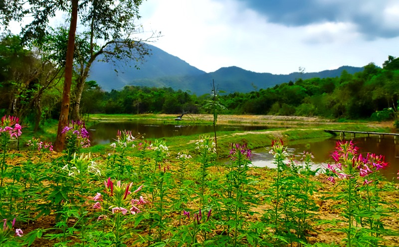
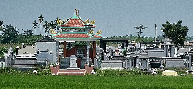
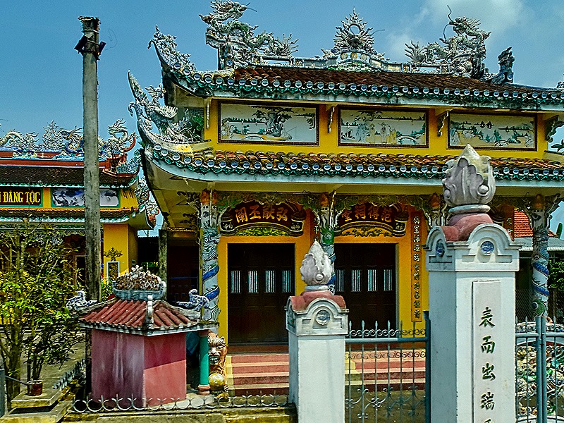
We spent March 19 docked in Da Nang, the third most important city in Vietnam with a population of about 1.3 million people. It is the most important port in central Vietnam, becoming that only when the Vietnamese king barred western ships from entering the previously dominant harbor of Hoi An. We visited Da Nang previously in 2016 for an overnight stay. We spent the first day in Hue, the last imperial capital: https://baderjournal.com/2016/04/10/; we spent the second day in Hoi An: https://baderjournal.com/2016/04/13/danang-vietnam-day-2-hoi-an/, Today our prime objective was the ruins of the ancient temple complex of the Cham people in My Son. This was about a two hour bus ride away, so we got started early. Passing through small towns and countryside we saw some interesting buildings, including several cemeteries, and a class of schoolchildren.


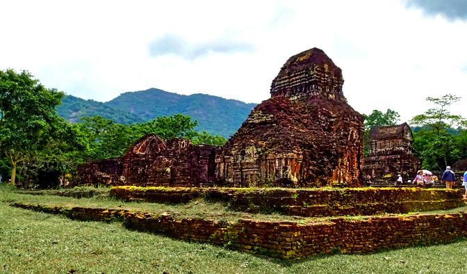
My Son was the religious and cultural center of Champa, which occupied most of what today is central Vietnam and was populated by the Cham people. The Cham were the original indigenous people in this area, having immigrated by sea some 2,000 years ago. They were heavily influenced by India and practiced Hinduism. My Son was a large complex of Hindu (and later Buddhist) temples built between the 4th and the 13th centuries, with each new king adding a new temple complex. The temples were dedicated to the Hindu god Shiva. It is thought to be the longest inhabited archaeological site on the Southeast Asia mainland.
Over the centuries there was a great deal of fighting between the Cham and others in the area, particularly the Viets and the Chinese. In 1832 the Vietnamese annexed what remained of the Champa kingdom. My Son fell into disuse after that and was largely forgotten, reclaimed by the jungle. A French archaeologist rediscovered it in 1898 and in 1937 the French began to restore the temples. But during the war in the 1960’s the Viet Cong established a base there and in August of 1969 US B-52s carpet bombed the area for a week. Of the more than 70 temples documented by the French at the beginning of the 20th century only 18 structures remain.
The bus dropped us off near the entrance but there was still quite a walk to reach the archaeological site. As we walked down the road our bus surprisingly pulled up, apparently having talked the guards into letting it drive us further, and took us to a spot near a bridge over the river where there were some small snack and souvenir shops. Beyond that point the road became a narrow walking path so the bus could go no further, but there was still a good distance to the site . . . and it was getting pretty hot. Nonetheless, we persevered and reached the first of two temple complexes we visited.


While we have been calling this a temple complex, not all the buildings are temples. There are storage buildings, perhaps some living quarters for religious personnel and the Champa monarchs were buried here, so there may be some tombs. Unfortunately we can’t really tell you which buildings are which, but it seems that the larger buildings are the temples and the smallest ones the storage units. These structures are built mostly of red brick and held together by a substance that is not visible from the outside. Originally, in the 4th century or so, temples here were made of wood. But a huge fire destroyed them early on and after that brick was used instead. Some of these buildings rise to a narrow, almost blunt, top. But others are topped by what looks like a smaller building with a saddle shaped roof.


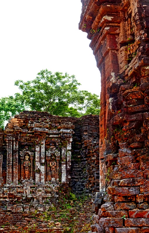
Most of the artwork from this site that survives has been moved to European museums or the museum in Da Nang we visited later. We did see what is left of a sitting headless sculpture and there are other relief sculptures that were carved directly into the brick walls.


The Cham people often included a phallic fertility symbol called a lingam in their temple complexes. Sometimes these are reduced to a cylinder shape, and they are sometimes enclosed in a metal cover called a Kosa which can have relief decorations. Some of them are gone and only the round base remains.


As we have mentioned, much of this area was destroyed or badly damaged by US bombing during the war and bomb craters can still be seen. But reconstruction is continuing. The French archaeologists took many pictures and made many drawings and wrote descriptions of what was here early in the 20th century, which gives a lot of guidance to the restorers. You can tell what is restoration work because the bricks are a lighter color and look newer than the old ones worn over time. We also noticed several buildings with scaffolding, but we are not sure whether that is for restoration work or just to give extra support to buildings in danger of collapse.


Some of the later buildings (still quite old) have details, like pillars, made of stone with carved decorations. There are also some steles with writing carved into them, although we don’t know what language they are. We understand that some of these memorialize the kings who built the temples.


We walked a little way through the woods and came upon another complex of temples. On the way we passed a few more that were partially hidden by the jungle. The second complex had a much greater concentration of lighter colored new bricks, so it must have received a large amount of restoration already.


Among other things, this complex had triangular niches in some of the walls that may once have contained sculptures. It also had some well preserved (or well restored) pillars, doorways and corridors. You could really see the new bricks, sometimes looking more like piles than buildings (maybe some of them were).


We left the archaeological site to return to the bus at the entrance. This time we had to walk the whole way and, although the surroundings were nice, it was really very hot. Probably not a good choice for people with walking difficulties especially since our guide was always in a hurry. We saw many flowers in the woods and fields and along a man made water feature, perhaps a reservoir. We did pass one more of the old buildings up on a hill in the woods.


Driving back toward Da Nang we passed some more colorful buildings and made a pit stop in a small town at the foot of the Marble Mountains, where a number of shops had large marble sculptures on display (way too big to carry home).


Back in Da Nang, we stopped for lunch in a nice restaurant off on a side street away from the busy traffic. Several courses of good Vietnamese food, some in sculptured presentations, and outside it was surrounded by gardens.


After lunch it was time for a rickshaw ride through this neighborhood and up along the river. We had a rickshaw tour of the Hutongs in Beijing just a week before, but this time it was one person per vehicle, the driver was behind instead of in front and, of course, it was an entirely different city in a different country. Our rickshaw drivers wore a uniform (of sorts) consisting of a cowboy hat and a loud Hawaiian style yellow shirt with palm trees. Very subtle.


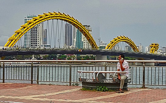
There was a sculpture display on the riverside walk but the main feature was the Dragon Bridge. Opened in 2013, it is quite arresting in the daytime but at night it is completely lit up and it spits smoke and sparks. Sadly we didn’t see that. The end of the dragon on our side of the river looks like it might be the head, but it is actually the tail with the head on the other side.


During this tour we saw the bright pink cathedral built by the French in 1923. It is called locally the rooster church because of a weather vane on top of the tower that is just outside the picture. There are some other street pictures here including a cafe with motorcycles parked on the sidewalk out front.


Speaking of motorcycles, anyone who has visited Southeast Asia knows that this (along with bicycles) is the ubiquitous form of transportation here. We have seen many creative uses of motorcycles to transport tools, boxes and even a family of five. Creative and interesting, but it doesn’t always look very safe. Some people here also bundle up in the heat of summer as if it were winter time, to protect their skin from the sun we have been told.


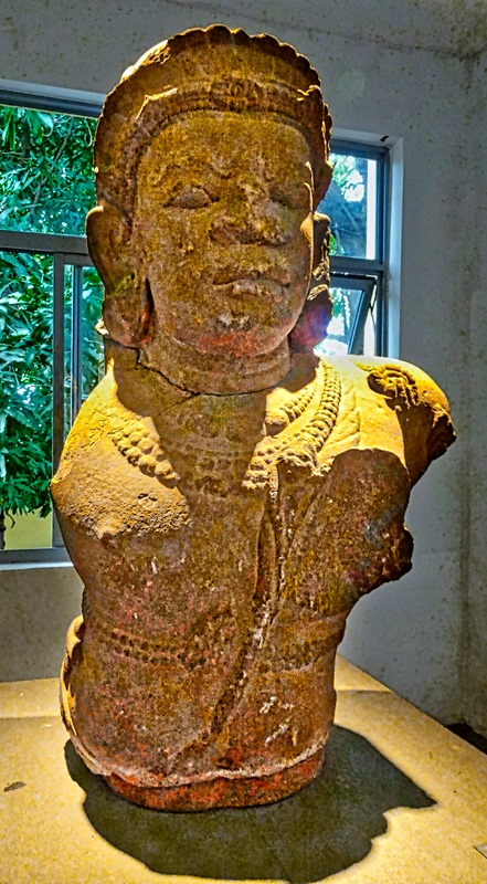
The last stop on our excursion was the Museum of Cham Sculpture, not far from the river walk. The museum was first opened to the public in 1919 and has been substantially expanded twice since then. It has the world’s largest collection of Cham artifacts, many from My Son, totaling more than 2,000 items. Most of the sculptures on display in the museum are more than 1,000 years old.

Some of the notable items there were a sculpture of Vishnu with four arms, a stone panel with a relief of the god Yaksa with curled hair, a sandstone guardian demigod dvarapala stomping on a bull, a 7th century male dancer carved into a step leading up to an altar pedestal, and a god (or goddess) sitting with hands on knees, possibly Lakshmi. Buddhism came to Champa late in the 9th century and the museum had an impressive display surrounding the largest Cham statue of Buddha on record.


In addition to individual sculptures there were a number of excellent reliefs carved into the edges of platforms or pedestals. The first picture here is of a pediment showing the birth of Brahma from a lotus flower growing out of Vishnu’s navel. We have read that the second one, depicting a dancer and musician (who may be goddesses) wearing many strings of beads and whose clothing is evidenced only by a cloth hanging between their legs, is considered one of the Chan masterpieces. The third is a flute player that is a detail from a much longer platform edge. Next are, apparently, two depictions of the goddess Durga, and below them is a platform edge showing the court of Champa, with the king in the middle and apparently a number of dancing women.


")

There was a large variety of other artworks on display, but our time was short and we only have pictures of a few more.


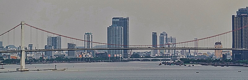
We returned to the ship, from where we had a wide view of the harbor with many fishing boats. The Thuan Phuoc Bridge, Vietnam’s longest suspension bridge at 1850 meters, which opened in 2009. The Tran Thi Ly Bridge has a single pylon and cables reaching out in both directions looking like a sail. When we saw it the cables looked red but we understand that it sometimes gets more colorful. We sailed away at about 11:00 after a rather fiery sundown.


