
Valdez, Alaska 2025
The morning of June 13 found us anchored across the bay from Valdez, Alaska, a small town (pop. almost 4,000) surrounded by imposing snow capped mountains. The nearby mountains towered over the upper decks and the view from our veranda included two tiny looking HAL tenders approaching the inlet leading to the protected dock. So welcome to Valdez!


")
The port of Valdez was named in 1790 by a Spanish explorer in honor of Spain’s Navy minister. But it was not until 1898 that a town was established here, after some steamship companies who promoted this as a better route than Skagway for prospectors to reach the Klondike gold fields. It wasn’t and many prospectors died trying to cross the mountains on a much longer and steeper trail than advertised.
In 1910 the opening of the Richardson Highway to Fairbanks established Valdez as the primary land route into Alaska’s interior. This highway started here primarily because this port could be used year round since it was ice free. But at that time Valdez was about four miles from where we visited it today. The 1964 Alaska earthquake pretty much destroyed the original town, now recognized as too unsafe to support a municipality. Over the next three years a new site was cleared and the entire town of Valdez, including 54 homes and buildings, was moved four miles up the coast to its current, more stable, location. Today there is virtually nothing left of the original town.
We had an excursion into the mountains scheduled for the afternoon, so we tendered into the small boat dock in town after breakfast to walk around and see the town.


Those of you who are familiar with this blog will not be surprised to learn that our first stop in Valdez was at the public library. For such a small town the Valdez Consortium Library is a very nice and well stocked library. Two stories with an open staircase and many colorful paintings and murals. And we can’t forget to mention all the books!


 behind the stairway")


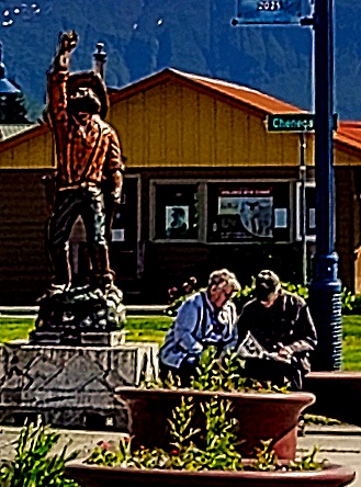
Across the street is the Valdez City Hall, whose architecture and coloring is similar to the library’s. In front is a wooden bear sculpture. There were a number of interesting outdoor wooden sculptures in Valdez. As we approached the City Hall we passed a couple from the ship talking with a local man. They left and he walked over to us. A very friendly guy, looking to be around 40 and wearing casual outdoor clothes, he spent some time telling us about the town and the sights. As we were leaving he told us he was the mayor of Valdez! We don’t know whether that’s true, but either way we appreciated that he went out of his way to be helpful to visitors.


We walked over to the Valdez Museum, which is full of very interesting exhibits detailing, among other things, the pioneer period, the earthquake and the Exxon Valdez oil spill disaster. The main streets of this small town are surprisingly wide with outdoor artwork and interesting buildings displayed against a backdrop of snowy mountains. It was June so the latest class had just graduated from the local high school and many of the lamp posts lining the sidewalks had banners, each with the name and photo of one of the graduates. Bear proof trash containers were on the streets as well, with a lever to open the top covered by a metal shield big enough for human fingers but not bear paws.


Our favorite Holland America ship was the Prinsendam (sold in 2019), on which we travelled three times. That ship joined the HAL fleet in 2002, but there was a previous HAL ship with the same name that sank in the gulf of Alaska in October of 1980 after its engine room caught fire. Despite 25 foot seas and 50 to 60 knot winds the Coast Guard managed to rescue every one of the more than 700 passengers and crew, many elderly, with no fatalities. The Coast Guard considers this the greatest rescue at sea in its history. We won’t tell the whole story here, but it is well worth googling.
The Prinsendam passengers and crew were crowded into open life boats intended for far fewer people (because some were unusable) and set out into the water a few hours before a typhoon hit. Most were rescued by helicopter but one boat was still unfound when they initially thought the rescue was finished. It was found a few hours later and the last of the Prinsendam passengers and crew were picked up. Many were in pajamas and some had torn curtains from the ship’s walls to use as blankets. Today that lifeboat is on display at the Valdez museum, in a covered outdoor facility. We were probably better off not knowing about this harrowing story during the years when we sailed aboard the successor Prinsendam.

In the afternoon we boarded a bus for our excursion into the mountains. Our first stop was the Solomon Gulch Fish Hatchery, dating to the early 1980’s, which breeds pink & Coho salmon. Millions of salmon hatch here each year and leave to spend their lives at sea, then return (as salmon do) to their birthplace at the end of their lives to lay eggs in the hatchery, with the entire cycle repeating each year. We understand that this place is full of returning salmon climbing the fish ladder to reproduce from July to September and that other wildlife, such as bears, sea lions, seals and eagles can also be seen here feeding on the plentiful fish. But unfortunately we were here in the middle of June and no salmon were to be seen. There were sea gulls and it was also a very pretty stop by the water’s edge. We had a view of Westerdam across the bay dwarfed by the massive mountains behind it.


We continued up the Richardson Highway into Keystone Canyon, with its high walls and nice waterfalls. In the first decade of the 20th century there was a heated competition to build a railroad from Valdez to the gold and copper fields inland. Keystone Canyon was the only route for a railroad through the mountains. An out of state railroad company financed by J.P. Morgan and the Guggenheims began building a path through the canyon but were challenged by a local company. So they posted armed guards and built a barricade across the canyon entrance to keep the locals out. On September 25, 1907, the two sides had a shootout, with one man killed and several injured. Public opinion favored the locals but both companies pulled out after the gunfight with the outside group building a railroad to the Copper River from Cordova instead (which ran until 1938). The banker who started the local company left town with many of his local financial supporters in debt. All that is left of this early railroad construction is a tunnel that was hand cut through solid rock.

 was dug")
Almost 29 miles from Valdez is the Worthington Glacier, one of the few glaciers in the US accessible by paved highway. But accessible does not mean there is no walking involved to get from the highway to the glacier. The area between the highway and the glacier is a small state park, which includes restrooms and a parking lot. From the parking lot it is a modest but very uneven walk to the glacier view. Beyond the highway in the opposite direction is a spectacular row of mountain peaks. Worthington Glacier has been receding for 150 years but much slower than many others in Alaska. Off to the right of the glacier (where Mary is looking in the first picture) was a picturesque river surrounded by leafless trees and bushes with more white mountains beyond.


The pull off to Worthington Glacier is from the Richardson Highway as it passes through Thompson Pass. Thompson Pass is a 2600 foot high gap in the Chugach Mountains, which is notable as one of the snowiest places in Alaska, averaging 500 inches of snow per year. It holds the Alaska record for snowiest day . . . 62 inches on December 29, 1955. Native people had been using this pass for many years when the US Army marked out a trail to the Klondike during the gold rush in 1899. Cars began driving through the pass in 1913 on what was named the Richardson Road in 1919. Until 1950, when snowplows were first deployed, this road was only usable in summer, then it was paved in 1955.
Leaving the Glacier we drove down the sometimes winding road through the Thompson Pass. It was a winter wonderland, even in the middle of June, with snowy peaks all around. We stopped at a pull-off viewing spot where we had quite a view of the surrounding peaks and valleys.


We descended back down into Keystone Canyon and left the bus to look at the waterfalls. Bridal Veil Falls (we have seen several waterfalls before with this obvious name) is some 600 feet high and Horsetail Falls, less than a mile away, is 300 feet. There is a third falls, almost as tall but noticeably narrower, not far from Bridal Veil. The falls are all on the opposite side of the highway from where we were parked and we were asked not to cross the road because it was dangerous. So the highway cut off our view of where the waterfalls drop into a river below. Still quite beautiful though.


We returned to the tender dock and then to the ship, driving past yet more stunning scenery. Valdez is the southern terminus of the Alaska Oil Pipeline, which brings crude oil all the way from Prudhoe Bay in Northwestern Alaska to a facility here where it can be loaded onto tankers for transportation to refineries. Because this is the northernmost ice free port oil can be shipped from Valdez year round. For those who can remember 1989, the Exxon Valdez oil spill that March let almost 11 million gallons of oil loose into Prince William Sound after the tanker ran aground on a reef. This was just a little more than a day after leaving Valdez loaded with 53 million gallons. A great deal of the wildlife in the area was killed and the effects were still evident decades later despite wide ranging efforts to clean it up. From our veranda we could see the tanks and facilities for handling the oil on this end of the pipeline, including a tanker waiting to load oil.


. The ship didn’t leave until late at night, after our bedtime. But here are a couple of towel animals, our nocturnal company in the stateroom, to end this very full day.


