
Taormina, Sicily, Italy
“Should you only have one day to spend in Sicily and you ask me ‘what is there to see?’ I would reply ‘Taormina’ without any hesitation. It is only a landscape but one in which you can find everything that seems to have been created to seduce the eyes, the mind and the imagination.” — Guy de Maupassant, 1885.
We arrived in Naxos harbor off Taormina, Sicily, on April 26. Located on the eastern coast of Sicily between Catania & Messina, Taormina has been a favorite retreat of the rich & famous, particularly authors, since the early 19th Century. D.H. Lawrence wrote Lady Chatterley’s Lover while living in Taormina & Nietzsche wrote Thus Spake Zarathustra there. Goethe’s praise for the town in his Italian Journey as “a piece of paradise on earth” landed it on the standard itinerary for the 19th Century aristocracy’s Grand Tour of Europe. It was chilly & overcast the day we were there, but the place was spectacular anyway, just as these authors would have told us.

Taormina was originally founded in the 4th century BC by settlers (some say refugees) from the Greek colony of Naxos founded in the 8th Century BC, which was located on the shore beneath the hills where the modern resort town of Naxos is now. Taormina has a long and complex history that I won’t go into here (do I hear cheers?), having changed hands many times over the centuries, from Greeks to Romans, Arabs and Normans, among others.
The dominant landmark in eastern Sicily is Mt. Etna, the largest active volcano in Europe, which was clearly visible from Taormina. As you can see, we were lucky in that it was putting out impressive plumes of white & gray smoke when we were there (suggesting that a new pope was both elected & not elected at the same time, reminiscent of the quantum physics conundrum of Schrodinger’s cat). I was told by somebody that the gray smoke is an indicator that an eruption is coming &, sure enough, the mountain erupted the week after we visited (darn!) sending fire in the air and hot lava down its sides. At the spot where we tendered ashore at the edge of Naxos to meet the shuttle bus to take us up to Taormina the shore consisted mostly lava rocks.


The shuttle took us through Naxos & then up a narrow winding road with very sharp switchbacks to Taormina, which is at an elevation of about 600 feet. At some of the switchbacks it looked like a near thing when two buses passed each other going different directions, but I am sure the drivers are very experienced at it. I sure wouldn’t want to drive on that.


We entered Taormina through the Catania Gate & continued down the main drag, Corso Umberto I. The first square we came to was the Piazza Duomo, named after the cathedral that fronts on the square. In the middle of the square is a fantastic fountain built in the 17th Century called the Fountain of the Minotaur. The Minotaur is the figure on top, but to me it looks more like the Red Queen from Alice in Wonderland.


 on top")


The Cathedral of San Nicolo was originally built in the 13th Century but the front portal was built in the 17th century. Lots of marble columns & altars inside and a good deal of very old art as well.


.")

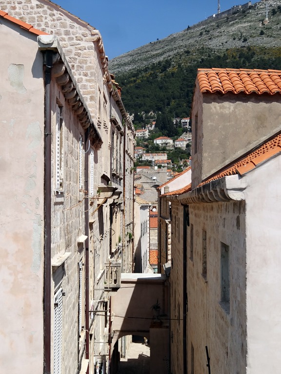
The streets of Taormna are pretty narrow, even the main street, & many of the side streets go steeply up the mountain, many with stairs. It doesn’t take many people before these narrow streets start looking crowded. But the streets are lined with 15th & 16th Century mansions, many of which now house shops, restaurants, cafes & bars. And there is a lot of interesting sculptured stone decorating the walls and brightly colored ceramic tiles.

 decorated with pots of flowers")


The next square was Piazza IX Aprile, a large open plaza on the very edge of the cliff. Of course this gave some spectacular views, but this plaza also has the Torre del Orologio (a clock tower) next to the Church of San Giuseppe. There was also the Metropole Café with its fabulous view.


")


But that’s not all, because in the Piazza IX Aprile we found the library, housed in a 15th Century church called San Agostino. And through its back windows were, of course, more great views.


We continued strolling down the road heading vaguely for the Greek Theater, enjoying the ambience of the town that included a lot of colorful flora.


 windows with blue ceramic heads. I wonder what was originally on those ledges.")


Taormina is full of expensive shops. We particularly enjoyed the colorful ceramics characteristic of Sicily & southern Italy. So here is some window shopping.


")


At the end of a side street called Via Teatro Greco is, you will not be surprised to learn, the Teatro Greco (Greek Theater). Originally built by the Greeks, probably in the 7th Century BC, it was completely reconstructed by the Romans on the Greek foundations (brick is characteristic of Roman architecture but not Greek), who used it for gladiator shows. It is the second largest ancient theater in Sicily with a diameter longer than a football field, but it is extraordinary more for its location on a cliff overlooking the bay with a view of Mt. Etna than for its size. As a bonus, the steep 6 Euro ($11) entrance fee was waived for those past their 65th birthday, so in effect the two of us were admitted for half price.


 but I'm not sure if all the stone seats are original")


Of course, there were many spectacular views from the site of the theater.


From the theater we walked to the Messina Gate on the opposite side of town from where we entered. Outside the gate we saw the San Pancrazio Church, which is built on the foundations of a Greek temple. We had a closer view of the Saracen Castle on top of Mt. Tauro & we passed the Roman baths (I think) just inside the gate. We were tired, so we decided not to explore further outside the gate since it was all either up or down a steep slope.


.")
 from outside the Messina gate.")
And then we walked all the way back through the town to catch the shuttle back to the ship’s tender port, stopping on the way for some gelato (can’t miss that). We saw a lot of delicious looking food in the shop windows but, amazingly enough, it was all made of marzipan! Taormina is famous for its marzipan, but I’m pretty sure its not as good for you as the real thing.


As we sailed out in late afternoon we took a final look at Naxos then headed for the Straits of Messina, which separate Sicily from the toe of the boot of Italy. These narrow straits were reputedly the basis for Homer’s Scylla & Charybdis in The Odyssey and large whirlpools have been known to appear there (although we didn’t see any). The straits are narrow enough that there used to be a wire between electrical towers on either side that was the source of electricity for Sicily. The wire is no longer there but the towers have been preserved, apparently for historical interest. It wasn’t all that dramatic, although there were some nice views as the sun was setting.


After dark we sailed past Stromboli, a small inhabited(!) island with a very active volcano that has been erupting regularly for several thousand years at least. We weren’t close enough to get pictures, but we could see the reddish eruptions clearly in the dark sky every 10 or 15 minutes. It was cold & windy, so we had dinner & went to bed to prepare for another long day in Naples (not one of our originally scheduled stops, but that story in the next episode). But in closing, we have to catch up on the Prinsendam’s food sculptures and towel animals.


Venice, Italy
Surprise, I’m back! This took a long time because we were out of town for 2 weeks. But as compensation (or maybe just an additional annoyance) this will be an unusually long post. Venice is such a uniquely beautiful place that it is hard to take a bad picture without some effort. So I am going to be even more self-indulgent than usual & include a lot of pictures, just because there are so many I like.
We sailed into Venice early in the morning on April 23 for a stay of almost 2 full days. Venice was founded in the 5th Century by people fleeing the chaos resulting from the disintegration of the Roman Empire and the incursions of the Goths. They escaped into a large inaccessible lagoon and built villages on a number of islands there. As time passed, the islands were connected with bridges and the city grew together. Because of its inaccessibility by land, the Venetian Republic (not like our republics, since only aristocrats & the wealthy were represented) relied largely on sea power to develop into a great empire that dominated the eastern Mediterranean for many centuries. We have seen its influence in such places as the Dalmatian coast cities & Cyprus. It came to an end when conquered by Napoleon at the end of the 18th Century and after his fall it was ruled by Austria until in 1866 when it was incorporated into the newly unified nation of Italy.
It was misty & overcast as we entered the lagoon in the early morning light & turned left to sail past the island of Lido, a long & skinny island that protects the Venetian lagoon from the sea. Lido is famous for its beach, which has given its name to countless beaches around the world & the main pool deck on most cruise ships (including Prinsendam).


Because this is such a swampy area, the buildings of Venice are supported by literally millions of wood pilings driven through the muck to the more solid clay level some 25 feet down. The pilings, many of which are well over 1,000 years old, do not rot because there is no oxygen down there to support destructive insects or bacteria. So think about all those invisible wood pilings (and the work it took to drive them in) as you look at the buildings that they support. We turned toward the right from Lido & sailed toward the central square of Venice, Piazza San Marco (St. Mark’s Plaza).

 & Piazza San Marco (r). We sailed through the chanel between them, in the center of the picture")


Passing Piazza San Marco we sailed by the entrance to the Grand Canal & the church of Santa Maria della Salute, built in thanks for the end of the plague of 1630. This building alone is supported by more than a million wooden piles.


, Lion of St. Mark on column to the left, Cathedral of St. Mark in background")

We continued through the channel between the island of Giudecca & the main part of the city. We passed the 16th Century church of Il Redentore on Giudecca, considered one of the masterpieces of Antonio de Palladio (from whose name comes the architectural term “palladian”), built in thanks for the end of the plague that killed a third of the population in 1576. We sailed on toward the port, on the west side of the main city islands, passing a variety of scenic waterfront views.


 in the center; there is a well known tilting tower on the island of San Pietro, but I am not sure whether this is it")
 & Santa Maria della Salute (rt)")


.")
As we approached the cruise ship port the sun began to come out from behind the clouds, giving a dramatic effect similar to sunrise.

After a shower & breakfast we started into town. We had been afraid, from the overcast sail-in, that the weather would be a problem but in fact it was sunny & beautiful throughout our stay. While one can get to St. Mark’s plaza by vaporetto (the floating public transportation system) we decided to walk since there was plenty of time and wandering through the streets is the best way to get a real feel for the city. During the almost two days we spent in Venice we walked between 16 and 17 miles according to Mary’s pedometer (which seems to underestimate a bit) and we enjoyed every minute of it.
The first third of the way (I am guessing about a mile & a half from the ship to St. Mark’s) from the cruise port wasn’t all that interesting. From the top of the ship you could see a good bit of the city, and the walk to Piazzale Roma, the limit for car & motorcycle traffic, gave us a view of the single long bridge to the mainland, first built in the mid 19th Century.


We walked into town with our friend Israel, a very engaging fellow who was the Rabbi on the ship. Prinsendam has a priest, a Protestant minister & a Rabbi (that sounds like the beginning of a joke, but it isn’t). I hope you made it this far in the blog Israel! Wherever there is water in Venice (which is just about everywhere) there is a beautiful view. The weather had turned very clear & sunny, which enhanced the reflections in the water.


")
The Campo San Rocco was bounded on one side by the Scuola Grande di San Rocco and on an adjacent side by the Church of San Rocco. St. Roch (Rocco in Italian) is the patron saint of contagious diseases & his body is under this 18th Century church. Scuola means school, but the Scuole of Venice were actually more like fraternal organizations than schools. We toured the Scuola on our second day in Venice; unfortunately no pictures are allowed because it was filled with beautiful Tintoretto paintings. I did manage one picture through the front door, but it really doesn’t give an idea of the grandeur in the upper gallery.


We continued wandering through the streets, generally in the direction of the Rialto Bridge, passing more interesting buildings & canals.


The Rialto Bridge is one of the iconic landmarks of Venice. This is reputedly the site of the first settlement in Venice which was called “Rivoaltus,” meaning "high bank," later shortened to Rialto. This has been the commercial center of Venice for a thousand years & the produce markets are still held in this area. The first wooden bridge was built on this spot in the 12th Century, but after two collapses (at least one under the weight or a crowd) a stone bridge was erected in the 16th Century. It was the only way to cross the Grand Canal on foot until the mid-19th Century.


The inside of the bridge is lined with busy shops and kiosks.


The Rialto Bridge and its environs also have gorgeous views of the Grand Canal. The Canal cuts through Venice in an S shape & this bridge is right by one of the turns in the Canal. The Canal in this area is lined with palazzos, cafes & docks with tall wooden boat mooring columns, and the water is filled with gondolas and other boats.


 (left) & Palazzo Bembo (15th C) on right.")
 in the background on right")

After crossing the Rialto bridge we continued on generally toward Piazza San Marco, passing yet more interesting spots on the way.


So finally we came to Piazza San Marco, one of the world’s premier public spaces. On the east side the Doge’s palace & St. Mark’s Cathedral sit side by side. Across the square is the Campanile (bell tower) and beyond that is a vast open space surrounded by buildings with colonnaded loggias housing shops, museums & cafes. There is so much to see in this area!


 on the right & the columns of St. Mark (l) & St. Theodore (r).")
Having looked at the overall scene, now we will take a closer look at the buildings & landmarks in the Piazza. We found the Biblioteca Marciana (national library of St. Mark) in the building on the right in the picture above. This building, erected in the 16th Century, is called the Libreria Sansoviniana (named after its architect) and Palladio called it the finest building since antiquity.


The first building we visited was the Doge’s Palace. The line to get in was almost non-existent, one of the big advantages to visiting Venice at the beginning of the season. We entered into the grand courtyard, with two story loggias on three sides & a wall of the cathedral on the fourth side. The cathedral originated as the private chapel of the Doge, so this gave him a private entrance; it has since been greatly expanded of course. The columns of the loggias were topped with intricately carved capitals each of which was different.


In the courtyard are a number of interesting sculptures. In the middle are two intricate cast bronze well heads. The Giants Staircase is a marble affair with huge statues of Mars & Neptune on either side at the top. There is an old gondola in one of the loggias (I’m not sure why) & a peaked roof over part of the cathedral wall with a number of marble statues. There is a clock tower at the top of the cathedral wall on the north side of the courtyard


 & Neptune (r)")


The rooms inside the palace were fabulous, full of old carved woodwork & massive oil paintings by Renaissance masters. Notable among them is Tintoretto’s “Il Paradiso,” one of the largest oil paintings in the world at 82 feet in length, which depicts 500 figures in portrait-like detail. Unfortunately, no photography is allowed of the rooms of the palace so I can’t show it to you here (you might try googling it). However, I did get some pictures of the elaborate ceiling of the Golden Staircase leading into the palace from the second floor loggia, and of the statues of Hercules & Atlas that guard the entrance to it. Also on the wall of the second floor loggia is a “Lion’s Mouth” mail slot, through which you could submit anonymous accusations against people you didn’t like. Venice had something of a police state mentality, always searching for potential traitors. One of the rooms of the palace has portraits of all the doges lining the wall under the ceiling all the way around the room . . . except for one who was beheaded for treason, whose portrait space is all black. The Italian inscription on the Lion’s Mouth means: "Secret denunciations against those who hide favors and offices or collude to hide the true income of them.” I was also able to get a few nice pictures out of upper floor windows in the palace.


 & Atlas (r)")
")


We crossed the Bridge of Sighs to visit the prison on the other side of this small canal, the Rio de la Palazzo. Prisoners were originally kept in cells in the Doge’s Palace, from which Casanova escaped. But they proved too cramped for the growing prison population so in the 17th Century a new prison (which still looked pretty grim to us) was built on the other side of the canal, with this bridge to connect the interrogation & court chambers in the palace with the prison. The bridge’s name comes from Lord Byron, who concluded that prisoners would sigh as they saw their last glimpse of the outside world as they passed through this bridge to the prison, often never to be seen again outside its walls. Again, no pictures allowed inside the prison, but there are a couple in a prison courtyard & through the windows of the bridge, which are obstructed by decorative stone grating. You may have seen this bridge & canal before, since James Bond & his Russian girlfriend go up this canal at the very end of From Russia With Love.
. This is the view in the Bond movie. Notice the small windows with stone grating through which the prisoners might have glanced.")


")


Next we visited St. Mark’s Cathedral (or Basilica) right next door to the Doge’s Palace, where it was originally built to house the remains of St. Mark who is thought to be the author of one of the Gospels. It is a magnificent building full of sculpture, domes & golden mosaics. So what’s the story about St. Mark? It seems that the original patron saint of Venice was St. Theodore. But the Venetians weren’t satisfied with this and in 828, either to fulfill a vision or aggrandize their city depending on who you believe, a delegation of Venetians went to Alexandria, Egypt and purloined his body. St. Mark was interred in Alexandria because he had been the first bishop there & was martyred there. The body was smuggled out of Egypt, secreted under a layer of pork to discourage the Muslim Egyptians from inspecting it, and brought to Venice where a church was built to house it. The church was rebuilt & expanded a number of times to reach its present magnificence. During construction of the Basilica in the 11th Century the body was lost (how does that happen?) but 30 years later it was miraculously “found” & reinterred under the Cathedral that bears his name (whether this body was really St. Mark or not seems to me to be uncertain). So St. Mark, whose symbol is a winged lion often holding a book, is now the primary patron saint of Venice & St. Theodore occupies a back seat (although his remains are in another church in the city). The Venetians are very proud of their body snatching caper; the Cathedral has a prominent mosaic portraying the stealing and transportation of the body to Venice.


Signs said photography was forbidden inside the Cathedral, but once inside we saw many flashes from cameras & no one seemed to be enforcing the rule. So I took a few photos as well. It wasn’t very light (and I didn’t use flash) so some of them didn’t come out very well. But you can see that the whole ceiling – domes & supports – was covered with golden mosaics, some of which are identified in the picture captions. The floors were also very beautiful with varied marble mosaics and there were polished stone columns of varying colors & marble panels on some walls reminiscent of Santa Sophia in Istanbul (where they might have come from, since the Venetians & Crusaders stole a lot from that church when they sacked Constantinople in 1204). Across the front of the area of the main altar is a row of statues of saints; the only one I know the identity of is St. Mark, fourth from the left in the picture below.


On the upper floor was a small museum, mostly housing items that had been replaced during renovations. Particularly interesting (to me) were some mosaics that gave a chance to see more closely how the tiles are put together to construct a lifelike face. Also there are the original bronze horses that stood above the entrance to the Cathedral for many centuries, recently replaced with exact replicas. These horses were probably originally made in Greece around 300 BC, then taken to Constantinople where they adorned the Hippodrome, then in turn purloined from Constantinople when the city was sacked in 1204 by the Venetians & Crusaders. Quite a history, and they are still quite beautiful after all that time outside in the elements.


The last place we visited in the Cathedral was the balcony atop the front entrance (which I pointed out in the caption to the first picture in the Cathedral section of this episode). On this balcony are the replica horses standing just where the originals used to be. The balcony provided excellent views all around the Piazza. To the right is the 15th Century clock tower, with a Lion of St. Mark above the clock & a bell on top rung by two figures called “the Moors” because of the dark patina of the metal. Directly across is the Campanile (bell tower), more than 300 feet tall with a beautiful entry porch at the bottom. The original 16th Century Campanile collapsed in 1902, but was rebuilt. To the left is the original grand entrance to the Doge’s Palace called the Porta della Carta (today you enter by a different door on the lagoon side of the building). It has a (19th Century reproduction of a previously destroyed) sculpture of the lion of St. Mark with a kneeling Doge Francesco Foscari, who built this entrance, then above the window is a bust of St. Mark and the whole thing is topped by a statue of Justice with sword & scales. From the balcony we also had a level view of the figures atop the columns near the water of the lion of St. Mark (which had a previous life as a different lion somewhere in Anatolia) & St. Theodore standing on a crocodile (which represents the dragon he is supposed to have killed). This is also a copy; the original is somewhere inside the Doge’s Palace (we didn’t see it). I have included here a few pictures of these items not taken from the balcony, just to give some context.


")


And to finish off our visit to Piazza San Marco, here are a few more random items that didn’t fit anywhere else. Venice is situated just above water level & is sinking a little every year, so in the winter time there is always flooding & Piazza San Marco is inundated with water. The Venetians have adapted to this by installing temporary wooden walkway to enable people to walk through flooded areas without getting wet. A few were still there in side streets when we visited. In the open Piazza square are several cafes with outdoor seating that also have small musical groups playing mostly light classics. In particular are two cafes that date to the 18th Century: the Caffe Quadri (shown in a picture at the beginning of the San Marco portion of this posting) on the north side & the Caffé Florian on the south side. During Austrian rule in the 19th Century, Austrians patronized the Caffe Quadri while Venetians hung out at Caffe Florian across the square. Both were frequented by many famous writers & composers. Attached to the southwest corner of the Cathedral is the porphyry statue of the “Four Tetrarchs,” another item plundered from Constantinople in 1204. Note the foot that has been replaced with a stone carving in the lower right; the original foot was discovered in Istanbul in 1960 & is in now in the Istanbul Archeology Museum. The sculpture was probably created in the 3rd Century when the Roman Empire was briefly governed by a group of 4 coequal emperors. Other pictures are identified in the captions.


We left Piazza San Marco & set out to find the La Fenice theater & opera house, as always passing engaging sights along the way.


")
Gran Teatro La Fenice, the opera house & theater, was first built in the 18th Century. It was destroyed by fire in 1836 and again in 1996 (by arson according to court verdict). The current building reconstructed after the latter fire opened in 2005. The burning & reconstruction of La Fenice (which means, aptly, “The Phoenix”) is the central story of John Berendt’s The City of Falling Angels, an enjoyable book that gives a good portrait of Venice.


After that we wandered around the streets for a while, which means more canal views (I hope you like these as much as we did, since I have included an awful lot of them in the blog post).


On our way back to the ship we stopped at a café by the Grand Canal near the Rialto bridge for a snack & to rest our aching feet. The food was great & so were the views (of course). Sitting there I was struck by the abstract patterns made by the reflections in the water. You see that in most of the canal pictures, but it is a different effect when they are isolated in a picture without context.


That night on the ship we had a show by local talent. Alas, it was not a folkdance or folksong group, as we have enjoyed in many other ports, but a pretty lame group of older guys dressed as gondoliers who sang overused Italian standards (Volare anybody?). What were they thinking when they booked this group?


Our second day in Venice was spent largely in museums. We went to the Academia, a renowned museum full of Renaissance & pre-Renaissance Venetian masterpieces. It pretty much lived up to its reputation, although a lot of the pre-Renaissance art didn’t do much for me. Unfortunately, no pictures were allowed. We then visited the Scuola Grande di San Rocco, some pictures of which are included earlier in the episode. The upstairs was a huge room jam-packed with Tintorettos and a few Titians on walls, ceilings & easels. Pretty impressive but again no photography. We had wanted to spend some time visiting the Ghetto area in the north part of Venice. Established in the early 16th Century, this was the first ghetto ever established for confinement of Jews. Its name came from the large foundry in the vicinity: “gheto” was Venetian for “slag.” The word ghetto acquired its modern meaning as other cities applied it to their confined Jewish quarters. Unfortunately we ran out of time in the museums (we had to be back at the ship in mid-afternoon to avoid being left behind), so this will have to await our next visit.
One place we did see the second day was the large Basilica di Santa Maria Gloriosa dei Frari. It has the second largest campanile in Venice and Titian’s painting of the Assumption over the altar area. Titian is buried in the Frari. We didn’t have time to tour the interior, & there was no photography inside anyway, but I managed a few pictures from the front entrance.


Some miscellaneous things we saw walking around town. Many of the plaza’s contained old covered wellheads that used to be the source of water for people living in the neighborhood. Venice is also known for the characteristic balconies with unusual arrays of windows in the many palazzos, each one of which is different. We also saw an interesting poster of a new version of Shakespeare’s Richard III. The good news: he’s not hunchbacked any more; the bad news: now he’s a borg!


One of the things we really enjoyed in Venice was looking at all the colorful shop windows. Venice is famous for glass, which is mostly made on the island of Murano. The glass here is very beautiful (& expensive).


")


Venice is also famous for its elaborate fancy-dress carnival parties and for the elaborate masks it produces for them.


Last, but far from least, were the shops selling baked goods & gelato, all deliciously displayed to make you want to eat it all. We did not try the baked goods, but we did have gelato on our way back to the ship. We had been looking for a gelato shop displaying the notice Rick Steves says indicates home made gelato, but although we passed a number of gelato shops (mostly just holes in the wall) we didn’t see any of these. So we stopped at a gelato stand on wheels in the middle of a plaza, since it was getting late. Wow! It was fabulous! Mary had a cone piled high with lemon & pistachio while I had pistachio & chocolate. It was easily the best ice cream we had ever had. All I can say is that real Italian gelato is to regular ice cream as steak is to hamburger (to be fair, although the gelato we had elsewhere was consistently better than ordinary ice cream it didn’t seem to live up to what we had in Venice, perhaps because in Venice it was completely new to us). If you visit Italy be sure to try it.


 glass case")

So we returned to the Prinsendam, which sailed out in late afternoon the same spectacular way we had come in. You have seen this route before, of course, but this time it was sunny, so I will show you some of the sailaway here. First from the port toward Piazza San Marco.


As we passed Piazza San Marco the late afternoon sun created areas of bright light and shadow.

 & the Winged Lion (r) at the bottom.")


We sailed on down past the waterfronts to the west of San Marco, took one final look back as the sun fell lower in the sky, and headed south toward Sicily.


Korcula, Croatia
On April 22 we arrived off Korcula, the last of our medieval walled cities on the Dalmatian coast. This was a tender port (ie. the ship is anchored and passengers go to and from the port by tender boat) and it was also a short day, with all aboard scheduled for 1:30. But we found this to be more than enough time for this small town, particularly since almost everything in the old city was closed for the off season (sadly, we were about 9 days too early for the start of the season). Korcula is another walled city on a small isthmus with orange terra cotta roofs & has been called a mini-Dubrovnik. This might have been a little more exciting if we had not been to the actual full sized Dubrovnik only 2 days earlier (and it might have been more interesting if the museums had been open and the Cathedral hadn’t been covered in scaffolding). Still, it was an interesting city to explore & we had a pleasant time (except for the cold weather).

Unlike many medieval cities, Korcula was built according to plan. It is shaped like a horseshoe crab pointing out from the land. The streets are laid out in a sort of herringbone pattern, with a main road running from the main gate toward the rounded point of the crab & rows of fairly straight side streets branching off at a bit of an angle in each direction. It is said that this plan was designed to protect from the harsh south winds but let in the pleasant north winds. Founded by the Greeks in the 4th Century BC, Korcula was later part of the Roman Empire and later was ruled by Venice for a number of centuries. It was part of Yugoslavia after World War I and again after World War II, and is now part of the independent Croatian state.
We entered Korcula by the 15th Century Land Gate, an impressive introduction with a grand stone staircase leading over what once was a moat-like canal to a large crenellated tower. This Revelin Tower has a relief of a Venetian lion of St. Mark flanked by the coats of arms of the Doge of Venice on the left and the rector of Korcula on the right.


 & rector's (r); the one below on the left is of the rector at the time the tower was renovated")


The inside of the gate was more elaborate than the outside & the tower was topped with a picture window (it was closed for offseason, so we couldn’t go up to see the view). To the left of the gate after entering is the 16th Century Rector’s palace, which had a nice loggia and a large stone plaque of the lion of St. Mark leaning against a wall. Nearby was an interesting shrine and on the right was the 14th Century Church of St. Michael. Apparently it was believed that a church dedicated to St. Michael inside the town gates would help ward off enemies. The stone overpass to the left of the church leads to the building of the Brotherhood of St. Michael.


We walked on to St. Mark’s Cathedral, the highest point in town. You can see it atop the city looking like a birthday candle on a cake in the first picture. Unfortunately, the cathedral was covered in scaffolding and canvas so we didn’t get to see what it looks like. We went in but no photography was allowed. Across the street is the Gabriellis Palace, which now houses the town museum (closed for offseason, of course).


The last real landmark in Korcula is the so-called Marco Polo’s house. Korcula claims the Marco Polo was born here in 1254, but there is no actual evidence that this is true and it is disputed by historians, who seem to think he was most likely born in Venice. As we have seen elsewhere, however, Korcula has a house claimed to be his birthplace (although it was apparently built a little too late for that) for tourists to pay to visit (but not in offseason). It is an imposing tower of a house with some lovely ruins attached, so it is worth seeing if you are in town whether Marco Polo ever lived there or not. Marco Polo does have a documented relation to Korcula, however. In 1298 he was captured by the Genoese in the Battle of Korcula, a sea battle in which he commanded one of the Venetian ships. While he was a prisoner of war in Genoa Marco Polo and another prisoner collaborated on the book about his travels to China that became something of a sensation (although few believed it at the time) and helped inspire Christopher Columbus to try to sail to China almost two centuries later.


")

While its streets aren’t maze-like, they are picturesque as in the other Dalmatian cities: narrow and often with arches and stairs.


This is, or at least was, a walled city. The town walls were built at least by the 13th Century, but they were extended and the fortified towers built over the next few centuries by the Venetians (each tower has a plaque of the lion of St. Mark). In the late 19th Century, when the Ottoman threat had long passed and Korcula was no longer a strategic outpost, the Korculans took down the top half of the walls to use for new buildings. But the walls with their massive defensive towers still make a substantial impression.


Outside the walls the city is surrounded by mountains, which were largely covered by clouds the day we were there. There is also a nice strip of waterfront with palm trees (Korcula is actually further north than New York), boats & an interesting monument with reliefs from the era of Socialist Realism.


So that was all for this very short port day, & we returned to the ship. Our friend Jerry (who took the picture of us by the stairway) was returning at the same time and was carrying an expensive SLR camera he had been given by the proprietor of a café where another passenger had left it. An impressive bit of honesty by the proprietor — since no one knew who it belonged to & the ship was getting ready to leave no one would have returned to ask him for it. Jerry did eventually discover the identity of the camera’s owner by pure serendipity (she was standing at the front desk of the ship when Jerry went to turn it in). She was very lucky! Anyway, we sailed away from cloudy & chilly Korcula and the Dalmatian coast to our first stop in Italy, Venice.

Kotor, Montenegro
We pulled into Kotor early in the morning of April 21. We had been told to be sure to arise early for our sunrise sail-in through the beautiful bay of Kotor, but we were tired from Dubrovnik & decided we need our sleep. Luckily for us our entry into the bay was delayed because the port authorities unaccountably gave preference to another cruise ship (our captain was quite irritated). I say luckily for us because this enabled us to see most of the sail-in, which really was stunning. There were rugged mountains surrounding the water, which was uncommonly still and reflective in the morning sun, and picturesque villages lined the shore. Often called the southernmost fjord in Europe, this is not really a fjord but a river canyon that has been submerged by the sea.
 in the bay of Kotor")


")


In the bay, near the village of Perast, are two islands. The tiny Island of St. George (I am using the English translations, obviously) is surrounded by a dozen Cypress trees and houses a Dominican monastery that has been in operation since the 12th Century. More interesting is the nearby Our Lady of the Rock, which is man made. It seems that on July 22, 1452 some sailors found an icon depicting the Madonna & Child on a rock sticking up out of the water. Thereafter sailors added rocks after every successful voyage and old boats were also filled with rocks and sunk there. Eventually a church was built on the growing island (originally Orthodox, it was later converted to Catholic). To this day, every July 22 the locals fill their boats with rocks & row out to add them to the island.
 & Our Lady Of the Rock on the right")


 & Our Lady of the Rock (right)")
As we were eating breakfast in the Lido during the sail-in an unusual sight appeared on the port side. A small village spotlighted by the morning sun while the surrounding mountains were still in shadow was covered by its own special cloud. I don’t think I have ever seen anything like it before, particularly with the spooky reflection in the water.


Another interesting phenomenon was the abstract patterns that appeared in the clear still water when the reflections were disturbed by the wake of the ship passing by.


So after all that, we arrived at Kotor & docked just outside the city gate. Kotor is a very small town (about 12,000 people, only about 3,000 live inside the walls) but it has a very long history. The Illyrians had a town here in the 3rd Century BC and by the 1st Century AD it was the Roman town of Catarum (meaning “strangled” probably after the turnings in the bay). An important trading port during the middle ages (its bay was considered the best port between Greece and Venice), when the Ottomans threatened in the 15th Century Kotor asked Venice for help and — by now you should know what’s coming – Venice remained in control for the next 350 years. Napoleon controlled Kotor long enough to build one of the first theaters in the Balkans, and then it was awarded to the Austrian Empire (for which it was the main naval base during World War I) by the Congress of Vienna in 1815. After World War I it became part of Yugoslavia (and its name was changed from Cattaro to Kotor). During World War II it was incorporated into the Italian empire, then after the war it was again part of Yugoslavia. In the Balkan war after the breakup of Yugoslavia Montenegro stuck with Serbia in a rump Yugoslavia, but voted for independence in 2006. Like Dubrovnik, Kotor was devastated by the earthquake of 1667 and it suffered another one in 1979, from which it has only recently finished rebuilding (at least it looks like this is finished).
The old town is laid out in a triangle surrounded by imposing walls, some 3 miles long and up to 50 feet thick & 65 feet high, which extend up the mountain behind the city to St. Ivan’s (St. John’s) Fortress at the top. Along one side just outside the walls runs the Skuda River.


")


")
We entered the town through the 16th Century Main Gate (also known as the Sea Gate or Western Gate). There is a pleasant green promenade outside the gate today, but back in the day the water came right up to the gate & security checks were completed (and taxes collected) before a ship could disembark. Above the gate is the seal of Tito’s Yugoslavia and the date when his partisans liberated Kotor from the Nazi puppet regime. There is also a quotation from Tito (translated in the caption of the picture). Nearby is a relief plaque of the Venetian winged lion of St. Mark, which I imagine might have been over the gate during the period of Venetian control.


")
On the inside of the gate as you pass through is a Gothic relief of the Madonna & Child, with the town’s patron Saint Tryphon holding a model of the town on the left & St. Bernard, a descendant of the local Pima family, on the right. Passing through the gate leads to Arms Square, the town’s largest square. Directly across from the gate is the 17th century clock tower with the triangular pillory in front, where miscreants were chained with placards around their necks stating their crimes so that passing citizens could freely humiliate them. To the left is the Rector’s Palace (the Rector was essentially a Venetian governor) & the Napoleonic Theater, both of which are now part of an upscale hotel.

 & St. Bernard (r)")


We wandered through the town a bit on interesting streets of red and white stone blocks highly polished, probably by years of wear. Like many medieval towns Kotor has a maze of narrow streets (which hinder invaders), some with arches above. There are several squares with sidewalk cafes & pumps topping public wells.


The next landmark we came to was the Catholic St. Tryphon’s Cathedral. The story is that in 809 a Venetian ship carrying the relics of St. Tryphon took shelter at Kotor during a storm. Every time they tried to leave the weather worsened, so they concluded that St. Tryphon wanted to stay in Kotor. St. Tryphon became the town’s patron saint & his relics are today in this Cathedral. You will notice that the towers of the Cathedral are not identical, supposedly because they ran out of money before finishing the second tower after the cathedral was damaged by the 1667 earthquake. It was Sunday and religious services were being held, so we didn’t go inside.


St. Luke’s Square contains two Greek Orthodox churches, tiny 12th Century St. Luke’s & the 1909 St. Nicholas which towers over it and whose black domes can be seen prominently over the city. Notice the Greek crosses atop these churches, with two (or even three) horizontal bars. The gold for the crosses atop St. Nicholas was a gift from Russia. You can see the priest in the door of St. Luke’s. When I took the picture he came walking toward us & I thought at first I was going to be admonished for photographing his church (it wouldn’t have been the only time). But he turned out to be unusually friendly. He had noticed me taking the picture & he invited us into his church, showed us around & insisted on taking our picture. All of this with sign language, as he didn’t speak English. At one time during the Venetian period St. Luke’s served both Orthodox & Catholic worshippers with an altar for each. Notice the impressive gold cross over the altar & the icon wall that pretty much filled the tiny adjoining room.


")


We saw one more church of note (seems like a lot of churches for such a small town). The Church of St. Ozana (also called St. Marija) is in a small green square with called Wood Square next to the town wall. Ozama was a local 16th Century nun who inspired resistance to the Turks. Scenes of her life are depicted on the bronze doors of the church.


Behind the church was a steep & narrow street that leads to the entrance to the top of the town walls. As mentioned, many of Kotor’s streets are narrow, many are topped with arches between buildings and many are also steep enough to need steps. This one was all of those, and it had a double arch above it with a medallion of a Venetian winged lion, the date of its construction (1760) & an impressive looking inscription in Latin that turned out to be just a mundane street sign (translated in the picture caption).


So we paid our 3 Euros apiece and entered the wall. Since we had just done the wall circumvention of much larger Dubrovnik the day before we decided we would climb the walls a little way going up the hill for a nice view over the city. From this area of the wall we could see the Prinsendam beyond the red roofs & spotted several of the buildings we had visited. It was not unlike the view from the wall in Dubrovnik.


Well, once we started to climb we didn’t turn back until we reached the top. It was exhausting for a couple of old folks and we stopped to rest (& take pictures) often. At one point we were thinking of quitting when we ran into some fellow passengers on their way back down who told us we were near enough to the top that we couldn’t quit, so we didn’t. In the end we were glad we pressed on, as the views were spectacular. We saw a lot of wildflowers on our walk; they were not all in one place but I am going to group them together here. I don’t know many of their names, but maybe some of you will.


The first landmark we reached was the 17th Century Church of Our Lady of Health, almost half way up the mountain. It seems that after the earthquake of 1667 rats poured into the city bringing with them the plague (when it rains it pours!). This Church was built by the survivors to thank God (and to help ward off any recurrence). Thus, the name.


Here is a good place to tell you about the wall walk. As you have seen, the wall snakes up the hill to St. John’s Fortress at the top. It would be much too steep to walk (or build) straight up, so the wall was designed in a series of switchback that zigzag as they rise. There are some 1350 steps on the path from the town wall to St. John’s Fortress. The steps are built next to a wall that is an extension of the downhill side of the wall, and next to the steps is a steep path or ramp. Most of the time you can walk up the steps using the wall extension on the downhill side as a bannister. However, in a lot of places the protective wall is worn down or completely missing (I wonder how many visitors they lose in those sections each year). In those sections we walked on the ramp, which was difficult because it is very uneven and often covered with some loose gravel. So the wall walk was not only exhausting, but sometimes treacherous. I guess this added to the excitement, right? We were amazed to see some badly overweight and even somewhat disabled people up there heading for the top, which of course provided another reason we couldn’t give it up and go back. There were also some people doing this strenuous climb in flip-flops . . . go figure. Here are some indicative wall pictures from various levels.


")


We completed the climb all the way to the top. St. John’s Fortress was the command post for the whole defensive wall system. The earliest ruins here date to the 3rd Century BC but Emperor Justinian built a castle here in the 6th Century AD and it has been substantially modified since, and incorporated into the city walls that were built between the 9th and 19th Centuries (but mostly in the 16th & 17th). Today it is in ruins, but interesting to climb about, and there is a large red Montenegrin flag over the front wall. The views here are spectacular and well worth the effort of the climb (which was actually a lot more fun than my whining about it might make it seem).


So that is pretty much it for Kotor, and it was a lot more than we had expected. We walked back down the mountain & headed back to the ship for a very late lunch (or maybe we just had ice cream). Then, while the shadows lengthened as the sun began to drop behind the mountains we left beautiful Kotor and headed for Korcula, Croatia.

Dubrovnik, Croatia
This was the first of three consecutive medieval walled cities on the beautiful Dalmatian coast. We arrived in Dubrovnik on April 20 and docked at the cruise port about 2 miles away, so we took a shuttle bus to the town (a few people walked it, but Mary still wasn’t feeling up to this).

This city was originally an independent city-state called Ragusa. It was a successful merchant state and managed to retain its independence for many centuries through a combination of diplomacy, bribery, luck and even compromise (becoming an independent tributary of Venice and then the Ottoman Empire). Independence was an important value to the Ragusans, whose flag bore the inscription “Libertas” and who were the first state to formally recognize the United States after it declared its independence. However, in 1808 Ragusa made the mistake (similar to what we saw in Malta with the British) of inviting Napoleon in to save it from a lengthy siege by the Russians and Montenegrans. The French obliged, but stayed and incorporated Ragusa into the French Empire. The 1815 Congress of Vienna at the end of the Napoleonic wars made Ragusa a part of the Austrian Empire, then at the end of World War I it became part of the new country of Yugoslavia. It was at that time that the city was renamed Dubrovnik. Today, of course, it is part of the Republic of Croatia that emerged, after a particularly nasty war, from the breakup of Yugoslavia. I would be remiss if I didn’t mention that this war was settled in 1995 by the Dayton Accords, negotiated in my home town of Dayton, Ohio.
The Dubrovnik we see today is a combination of old and new, the result of disasters that destroyed much of the city. The first was the earthquake of 1667 that killed about 5,000 citizens and leveled most of the public buildings (but not the walls). The other was the Balkan war of the 1990’s mentioned above that resulted from the death of Marshall Tito and the consequent breakup of Yugoslavia. You can see from the picture above that Dubrovnik is situated at the foot of a mountain & it was subject to brutal shelling during the war from Serbian guns. The city has been impressively restored, using the same materials & methods as originally, but the damage is still clearly visible in the large majority of the iconic orange roofs of the city that are new and bright, easily distinguishable from the duller and browner original roofs that remain.


We entered through the PIle Gate (on the right in the picture at the top). Above the gate is a statue of St. Blaise, who has been the patron saint of Dubrovnik since the 10th Century when he was credited with saving the city from a Venetian attack. The gate is reached over a drawbridge that once spanned a moat. The stone bridge leading to the drawbridge was built in the 16th Century.


 & city walls (left)")

The number one thing to do in Dubrovnik is to walk around the city walls, so that is what we did first. There is a small fee in money & a large expense in energy, since the walk is about a mile & a quarter and much of it is very steep. It feels like it is all uphill, but of course that is impossible outside of an Escher print. The walls are up to 80 feet high and up to 25 feet thick and there are several fortresses and towers built into them. They were built from the 12th to the 17th Centuries and have never been breached by a hostile army. The wall walk began, predictably, with a climb up a long & steep stairway, then one must walk counterclockwise around the city. The first landmark is the Fort of St. Lawrence, which is set on a rocky outcrop outside the city beyond a tiny bay with beautiful clear blue water.

 & Fort of St. Lawrence")


We continued along the seaward portion of the wall, from which there were grand views of the bay.


On this part of the walk we passed an area of ruins from the 1667 earthquake with blue irises growing inside. We also walked above the back yards of some homes where people were living (not many people actually live within the old city any more). I would find it difficult to live where tourists look down into your yard all day every day. There was a shop on top of the wall selling embroidery and also cold drinks. And here (as everywhere) there were nice views of the city as well.


 yard below the wall")


")


Next we came to the old harbor, on the far left side of the first picture in this installment. It is too small for cruise ships, although some ships anchor nearby and tender their passengers to this port. It is bounded on one side by the Fort of St. John (at the far left in the first picture in this posting) and on the other by the Revelin Fortress.


 in background")


After the harbor, we turned the corner and climbed the steepest part of the wall (in the foreground in the first picture in this episode) toward the Minceta Tower, which is the highest point. The views from this part of the wall, looking down on the city roofs, were even better than before.


The Minceta Tower is the highest & most prominent structure in the Old Town.


We climbed to the very top & were rewarded with spectacular views of the city far below. I hope you are not tired of the orange roofs yet!


Leaving the tower, we walked back down to the Pile Gate where we had entered the wall & descended into the city. This is a good place to take a closer look at the tiles on the roofs, and also to see some flora & fauna we saw from the wall.
 the old tiles")


As you leave the stairway from the wall, just inside the Pile Gate is the little Church of St. Savior’, built after a 1520 earthquake & one of the few buildings to survive the 1667 earthquake. It is nestled next to the large Franciscan Monastery (now a museum) built in the 14th Century but mostly rebuilt after the 1667 earthquake, which has a nice cloister inside and a tower visible from most of the town. In the square in front of these buildings is the 15th Century Big Onofrio Fountain. Dubrovnik’s water came from the mountains on a 7 mile aqueduct that supplied this fountain, where townspeople drew their water, before continuing to other spots in the city. It once had a second story, lost in the 1667 earthquake and never restored.


Stretching all the way across town from the Pile Gate to the clock tower in front of the harbor is the Stradun, the broad main avenue of this city of narrow streets. Dubrovnik was originally divided into two parts: a slavic town on the mainland and the city of Ragusa, built by leftover Romans, on an island barely off shore. In the 11th century the area between the island and the shore was filled in and the city became one. The Stradun is where the water used to be; it was paved in the 15th Century. This lively avenue is full of expensive shops and outdoor cafes (and, of course, tourists).


As you have seen above, at the harbor end of the Stradun is the clock tower, originally built in 1444 but rebuilt in the 1920’s because it was leaning. There is a clock at roof level & a digital time display in the two windows below. The bells in the tower are rung by two bronze figures, known as Maro & Baro.

, now a restaurant")


In front of the clock tower is the Square of the Loggia, which is the political center of the city. To the left of the clock tower is the Sponza Palace, originally built in the 14th Century and sporting (of course) a loggia on the first floor. It was once the customs house, but is now the city archives. Across the square is the Church of St. Blaise and in front of it is the 15th Century Orlando’s Column, where the town crier gave news of government actions and where prisoners were pilloried. Orlando was a Frenchman also known as Roland, the subject of the medieval poem “Song of Roland.” The forearm of the statue was the standard of measurement in the city, called an “elbow.”


To the right of the clock tower is the city hall, then the Rector’s Palace, with another nice loggia. In the medieval city, the Rector was the head of government. Elected by the aristocracy, the rector’s term was limited to one month to ensure against an accumulation of power by any one person. The Small Fountain of Onofrio is next to the Guard House.


 over the door of the palace in the background")


Not too much further is the Cathedral. It was originally built in the 12th Century by, of all people, Richard the Lionheart of England in gratitude (to God, not Dubrovnik) for surviving a shipwreck on Lokrum Island, just off shore. Like so many old buildings in Dubrovnik, however, it was destroyed in the 1667 earthquake and the version seen today is an 18th Century reconstruction. It has a famous treasury containing several of St. Blaise’s body parts in addition to what is claimed to be a piece of the True Cross & even a piece of Jesus’s swaddling clothes (known locally as “Jesus’s nappies”). Unfortunately, you have to pay admission to see the Treasury, and we didn’t. I wonder what Jesus, who famously tried to throw the money lenders out of the Temple, would think about a church charging money to view his diapers (which is how they are labeled in English in the treasury). All of the almost 200 relics in the Treasury are in containers so you can’t really see them anyway.


Overlooking another square nearby is the massive Jesuit Church, which can be seen from far away overlooking the city. The staircase leading up to it is said to have been modeled on the Spanish Steps in Rome.


While waiting for Mary to peruse a couple of stores I happened upon this interesting building. It looks like a perfectly ordinary building, but on the side of it are posters showing it burning after being hit by a shell during the war. Its kind of chilling, but it also shows how well the city has been rebuilt to look as it did before the war.


After exploring the city we decided to take the cable car to the top of Mt. Srd behind the city. The old cable car was destroyed during the war & the new one they built just opened in 2010. The station is a little way uphill from the city wall, so to get there we walked out the Ploce Gate on the land side of the harbor and across the stone bridge spanning what was once the moat. The view from the top was well worth the effort.


At the top of the mountain is a fort built by Napoleon. During the Yugoslav war this fort held out against the Serbs with only a few dozen men inside, which was important because it commands what could have been a decisive position over the city. The fort still bears holes in its walls from shelling during the war. There are spectacular views up and down the coast from this spot., and behind it are the imposing mountain range that separate Croatia from Bosnia.


Coming down from the mountain, the last thing we wanted to see before returning to the ship for some ice cream was the Sephardic synagogue. While there was a Jewish community here before, large numbers of Jews began passing through Dubrovnik on their way to Turkey after the Spanish expulsion in 1492 and a number of them settled here. A walled ghetto, locked at night from the outside, was established just inside the Ploce Gate in the middle 16th Century. Dubrovnik’s synagogue is the second oldest continuously functioning one in Europe (Prague’s is the oldest), although there are now only about a dozen Jewish families left (of 24,000 Jews in Croatia only about 4,000 survived the Nazis). Anyway, the synagogue is a small building that proved difficult to find among the narrow & steep (with stairs) streets of this part of Dubrovnik. Really, you wouldn’t know you were there until seeing the sign on the door. Inside is a museum & a shop selling interesting Judaica.


Just a few random things before the end. First, this is as good a spot as any to mention that one of Croatia’s claims to fame (or infamy) is the invention of the necktie. The French word “cravat” is actually a corruption of “Croat.” They became fashionable in France when a group of Croatian mercenaries who were hired by the French king in the 17th Century sported them as part of their uniform. Second, I wanted to include a picture of one of the streets, which are really quite attractively made of fitted limestone (I think) blocks, with a trench built in for draining rainwater. Third, there was a group of young men who caused a bit of a stir marching down the Stradun carrying a Croatian flag and singing what sounded like a patriotic song. I don’t know if they were a nationalist group or just a bunch of guys unwinding after work. Then there was this little yellow bird I spotted on the top deck of the ship during the sea day between Athens and Dubrovnik. We were having a get together up there, and the whole time this bird kept walking back & forth across the deck. He must have unknowingly sailed with us from Athens, and he looked like he was thinking “Oh my God, what have I done?!” I hope he made it to Dubrovnik & was able to start a new life.


So, as we set sail for Kotor, I will leave you with . . . towel animals! You may have seen these designs before; we did have a number of repeats (I imagine they don’t have 64 different towel animal designs). I hope to have the next installment up in less time than it took for this one, but I have discovered that there are so many distractions at home (washing dishes, doing laundry, gardening, seeing friends, driving to Minneapolis) that it seems to take a lot longer to finish them than it did on the ship. I will get it done eventually, though.


