Dalian, China 2024
We spent March 10 in Dalian, the largest passenger port in China, located on the shore of the Yellow Sea at the southern end of the Liaodong Peninsula. With a population between 7 and 8 million people, this is another to add to the long list of huge cities we have visited we didn’t know about until they appeared on our itinerary. While this area was home to fishing villages for centuries, the city was not founded until the Russians took control in 1895 and began to build a modern naval port to be the home of its Pacific fleet because this was the northernmost ice free coastal site in the western Pacific. The Russians built a town they called Dalniy (“far away”) and modernized the nearby Port Arthur for its Asian fleet.
Port Arthur (named for a 19th century British naval officer, perhaps during the short British occupation in 1858 during the 2d Opium War) was the focus of the Russo-Japanese war that ended in 1905 after the Japanese defeated the Russian navy here. This was a shock, because Russia was a European major power and Japan had only begun modernizing 50 years before. Japan was ceded control of the peninsula in the Treaty of Portsmouth. After the end of World War II China regained sovereignty over the area, although the Soviet military did not leave until 1955. In 1950 Lushun (formerly Port Arthur) was merged with Dalian to form a city called Luda, whose name reverted to Dalian in 1981. So, although we had not heard of Dalian before this trip, we had known about Port Arthur, which is now a district of Dalian.
There was a shuttle available to downtown Dalian (a long walk away), but as mentioned in the previous post of our first day in Shanghai – https://baderjournal.com/2024/08/16/shanghai-china-day-1-2024/ – because we had not gotten Chinese visas we could only leave the ship on a HAL sponsored excursion (or one operated by someone approved for the purpose by the Chinese government). But HAL (Holland America) was only offering 3 excursions, all less than 4 hours long, so there was not much to choose from. We surely wanted to see what we could of the city rather than spend the day on the ship, so we signed up for the longest of HAL’s excursions as soon as the visa-free program was announced (we think we were the last to get places on this tour). So off we went in the morning after breakfast, driving through a city that turned out to be full of tall skyscrapers and open city parks.


Dalian was originally built by the Russians beginning in 1895 and named Dalniy, replacing a small town called Qingniwa. Russian Culture Street, which we visited first, is the oldest street in town. Several of the buildings erected by the Russians were still there in 1999 when Bo Xilai, the mayor of Dalian, began the project to restore this district. Russian architects were employed to renovate eight old Russian buildings, add so-called Russian facades to six other buildings and build six new buildings in a Russian style. For the most part we don’t know which buildings are old and which are new, but none of them look Chinese (except for the signs outside them in Chinese). The area is somewhat atmospheric, but also highly commercial with many vendors selling tourist items you might expect to see in Eastern Europe rather than in China. We reached Russian Street through a side entrance, walking under a sign that is apparently lighted at night.


 with sign in Russian instead of Chinese")
We saw some buildings seemingly dressed up for an occasion, such as with flower arrangements, but we don’t know what the occasion might have been. Maybe it was for our ship’s visit to Dalian . . . we were told we were the first cruise ship to stop here since the pandemic. Or maybe they keep it that way all the time to help attract tourists.
")


It was Sunday morning and bright and sunny (but rather cold) so as time went on more and more people were out and about. We stopped to watch a mother trying to teach her son (presumably) how to fly a kite.
 and kite on the ground (left)")


We didn’t get a lot of guidance from our very young guides about where to see original buildings or what their identity was. But we did walk past a Russian Orthodox church we think was old and a large curving building that might once have been a hotel.


We spotted the main entrance to the Russian street and walked over to take a look. The large arched sign was over a wide avenue leading straight to the original Russian city hall. There was a big crowd there (and we didn’t know what that building was at the time) so we didn’t get close to it. If we had, we would have seen that it is much bigger than this picture seems, stretching out to the right and left.

")
![]()
Finally, a few more random pictures of unidentified buildings, one of which had a large sculpture of a Russian nesting doll in front (along with a small elephant?). A lot of the trees in this area were decorated with what looked like balloons in red and yellow, all in all quite festive looking.


As we drove through town to our next destination we noticed that the whole town seemed brightly decorated with red lanterns and balls (balloons?). Among other things, we passed what we think is Olympic square, built in 1998 in anticipation of the 2008 Beijing Olympics.


Xinghai Square in Dalian is the largest city square in the world with a total area of 270 acres, all of it reclaimed land. Its name means “the Sea of Stars.” We aren’t sure what the definition of “city square” is, but Central Park in New York is three times as big. Xinghai Square was built to commemorate the return of Hong Kong to China and opened in 1997. At the edge of the water is the Centennial City Sculpture, a huge stone sculpture of a book lying open on the ground, with its ends curling upward. It provides a large space for people to walk on and take in the view of the Xinghai Bay Bridge across the water.


Leading up to the Centennial City Sculpture from the square’s interior is the long and low copper Sculpture of 1000 Footprints. It was completed in 1999, marking the centenary of the city’s founding. The footprints were made by Dalian citizens, starting with people born in 1899 and progressing toward the water with footprints of people born in 1999 at the end. Also at the end is a sculpture of two children who appear to be playing in the surf. When we were there it was surrounded by what looked from a distance like a bed of red flowers, but on closer inspection it appears to be some kind of carpet (look closely in the pictures and you can see some wrinkles).


The square has a very large lawn area and is landscaped in bushes which, at least when we were there, were red. The red bushes really stood out against the yellow grass. Kite flying seems to be popular in Dalian; we saw a number of people flying kites, many quite high in the air.


On one side of the square is the Dalian Shell Museum, opened in 2015. The building is shaped like a clam shell, slightly opened where the windows are placed. Next to it is the colorful Xinghai Bay Amusement Park.


")

Most of the periphery of the park on the land sides was surrounded by tall buildings, reminding us of the view on the edges of Central Park in New York. In the business center area north of the park many of the buildings were glass and steel, but on other sides were a lot that looked like an older style made of concrete. Several of these rows of buildings appear in the pictures above. Most notable to us was a building that looked like an old European castle on a hill, appropriately called the Castle Hotel. Despite its appearance this hotel is only 10 years old.


Finally (of the things we saw in the square), there are thirty groups of white steel mesh sculptures surrounding the square. Constructed for the 2008 Olympics, they depict athletes in action in a variety of sports. We only saw a few, but they were striking. Lighted at night they are probably even more striking. We also happened upon a pair of equestrian sculptures, but they weren’t of the mesh variety.


As we drove away from the square we passed a river or canal lined with tall buildings and an interesting green and white skyscraper.


Dalian’s first municipal tram line opened in 1909 while it was under Japanese control. By the end of World War II eleven tram lines were in operation. During urban renewal in the 1970’s most of the tram lines were removed and today there are only two. A ride on the tram was the last event on our excursion.
Reading the excursion description we (or at least Rick) had envisioned riding on an overpass or along the side of a hill with a panorama of the city out the window. It didn’t really say that explicitly, but that was what we were hoping for. Alas, no. This is an old fashioned urban tram, running (slowly) on tracks laid out on city streets, with little to see out the windows to the sides. And the ride only seemed to be about a mile in length. Our excursion was led by two very young guides, maybe 20 or so, who spoke excellent English but did not seem very experienced. They told us afterward that they had been very nervous about this excursion because we were the first cruise ship in town since the pandemic. If we were correct in our perception of their very young ages that means they probably had been too young to have done this before. The young woman guide had a microphone and did an explanation during our tram ride. She was quite articulate and had obviously prepared carefully for this. The guides were delightful, but the tram ride itself was disappointing.


Dalian is known for its large open city squares and we passed several on the bus on the way back to the port. One was a sculpture of what looked like a toad sitting on a pile of money and the other we got a photo of had a large green and purple sculpture in the middle with large Chinese characters in front. We have no idea what either of these signified.


Back at the port we went through customs and boarded the ship. There were a number of police officers milling about near the ship entrance but we don’t know whether this was usual or something special. We took some pictures from our veranda, of the dock off to our left and of the city in the distance on the right. A Chinese flag was flying on the dock as well. On a trip that includes places like Beijing and Kyoto it would be hard to justify calling Dalian one of the highlights, but it was a good bit more interesting than we had anticipated and we enjoyed our day here. At around 5:00 we sailed away to our next stop tomorrow.
Shanghai, China (Day 2–Suzhou) 2024
We woke up VERY early on the morning of March 8 to get ready for our excursion to Suzhou that was to leave at 6:30 AM. From the travel literature it appeared (at least to Rick) that Suzhou was a comparatively small garden city just outside Shanghai with a traditional ambience centered around a canal with arched bridges and much greenery. Much of that was true, but with a population of 5 or 6 million (one of the 60 largest in the world), Suzhou is anything but small.
Actually, Suzhou (formerly westernized as Soochow) has been a major commercial and manufacturing center for centuries. Founded in 514 BCE (under a different name, becoming Suzhou in the 6th century), by the 10th century it was the largest non-capital city in the world, eclipsed by Shanghai only in the early 20th century. Its size and importance began to decline relative to Shanghai in the second half of the 19th century, partly due to the devastation wrought by the Taiping rebellion in the 1860’s and the Boxer rebellion in the 1890’s, and partly due to the growing importance of Shanghai’s port in international sea trade and the deterioration of the Great Canal, of which Suzhou was a major trading hub. From the late 1930’s to the end of World War II Suzhou was occupied by the Japanese, with further damaging effect, but beginning in the 1950’s its economy and beauty have been substantially restored.
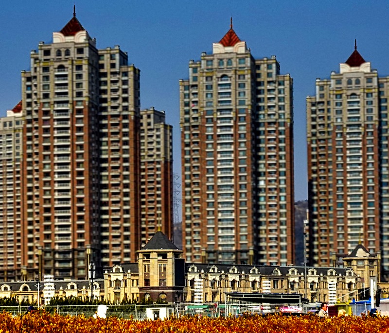
As we drove into Suzhou we began to get an idea of how large it really is, with many large complexes of tall and characterless apartment buildings (this was actually characteristic of everywhere we went in China).


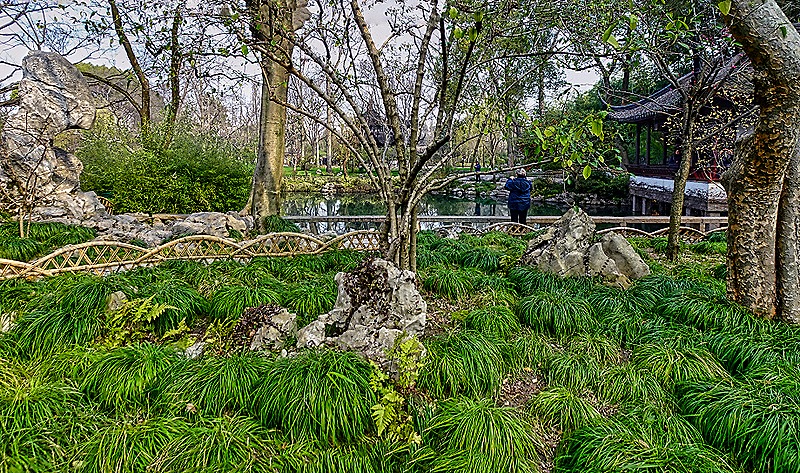
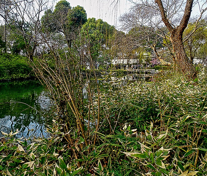
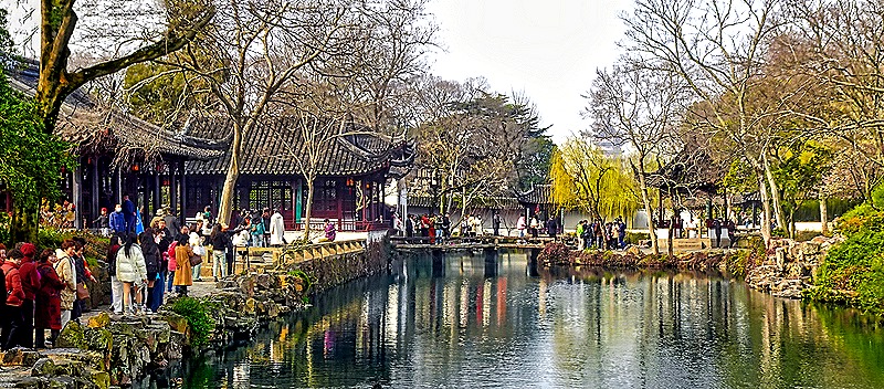
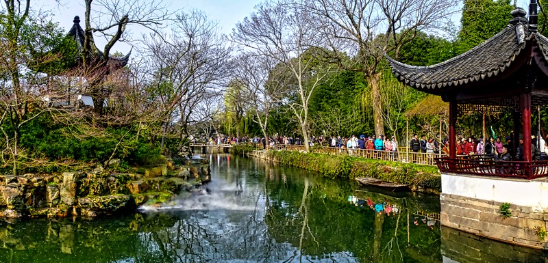
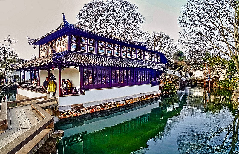
Suzhou has some 69 classical gardens and we visited the largest (13 acres) and most renowned, the Humble Administrator’s Garden. In 1509 Wang Xianchen retired from his government job, which he found unrewarding, determined to lead a simpler life growing plants and vegetables. He built this garden over the next 16 years and, when he died, his son disposed of it to pay gambling debts. At least that is the most popular version. We have read that the name of the garden has alternatively been translated as the Inept Administrator’s Garden or the Unsuccessful Politician’s Garden and our guide told us that Wang was actually forced to resign by the Emperor because of corruption. We don’t know what is true here, but either way the Garden is extremely beautiful, even in winter when we visited and many trees were bare and few flowers had grown.
The classical design of the garden is built around four main elements: rocks, water, plants and buildings. The idea is to provide a contemplative environment through which one can walk and enjoy the vista in every direction. If it weren’t for the crowds of tourists that showed up beginning in mid-morning this garden would undoubtedly achieve that aim. Inside the entrance were flower gardens, among the few flowers we saw already in bloom.


")
This garden is larger and has a much more open feeling than the one we saw in Shanghai yesterday, partly because there were a lot fewer walls here. The vistas were generally more vast and the combination of buildings, trees and water were hard to beat. Keep in mind that later in the year many of these water features would have large numbers of lotus flowers floating on top. Also there would be a lot more greenery after the trees leaf out.


This shows the “Whom-To-Sit-With Pavilion” in the center, with roof, stone floor and window shaped like fans. Reputedly named for an old poem: “With whom shall I sit? Bright Moon, gentle Breeze and myself.”

Particularly attractive was the “Green-Embracing Pavilion,” which had a moon shaped window in an open grid-like wall with a decorative rock on display in the center.


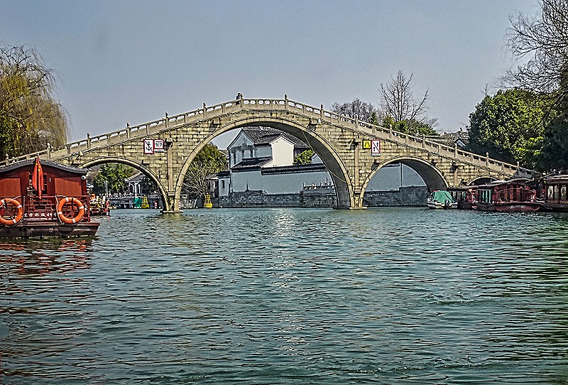
We have read that the “Small Flying Rainbow Bridge” is a rare type of bridge, but we don’t know what makes it rare. It is, however, quite beautiful and tranquil.

Many of the stone buildings in the garden have windows with decorative grills, the sort that let you see out while people passing outside cannot see in. The notable thing is that the decorative grill on each window is different from all the others. Here is a wall of such windows and the views out of four others.
")


Several other vistas were particularly stunning. One of them has a pagoda in the distance beyond the water and a stone bridge. We think this is the octagonal 249 foot tall Beisi Ta, originally built in the 12th century and last renovated in 2006. There were Mandarin ducks in this pond, an amazingly well decorated species thatis a symbol of fidelity in China.


A second fetching water view was seen through the attractively carved shutters of a pavilion, possibly the “Tower of Reflection.” Note in the distance what looks like a pagoda shaped cupola behind the building, which can be seen in closer views below.

 shutters in the pavilion")


While this all looks very natural, it is actually carefully planned and constructed to provide the desired views. You can see that clearly in one scenic bend in a water way where there are pipes that emit a mist to create the desired atmosphere.


This seems to be the two story “Mountain Viewing Tower,” with a zig-zag bridge leading to it, said to represent a dragon (round opening on the left is the mouth, slanting stairway in the back is the tail).

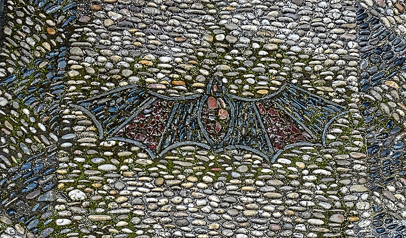
Not to be neglected are the pathways, many of which are stone mosaics, most with patterns but some with pictures of wildlife.


We left the gardens through a building filled with period furniture. There was also an intricately carved palanquin in which the family of one of the owners were carried around town, and a relief map of the gardens that appears to be sculpted in stone.


Everyone knows about the Great Wall of China, but before this trip we had never heard of the Grand Canal of China. At more than 1100 miles it is the longest canal in the world. It is also the oldest canal in the world, the oldest parts dating to the 5th century BCE. The modern “pound” locks (with two gates that allow raising or lowering a boat in the area between them) were invented by the Chinese for use on this canal in the 10th century CE. The section of the canal that runs through Suzhou was built early in the 5th century BCE. While the canal has had its ups and downs, it made Suzhou a commercial powerhouse during the middle ages and, after some reconstruction and improvement after the 1949 revolution, it still carries a large amount of Suzhou’s trade today.
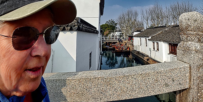
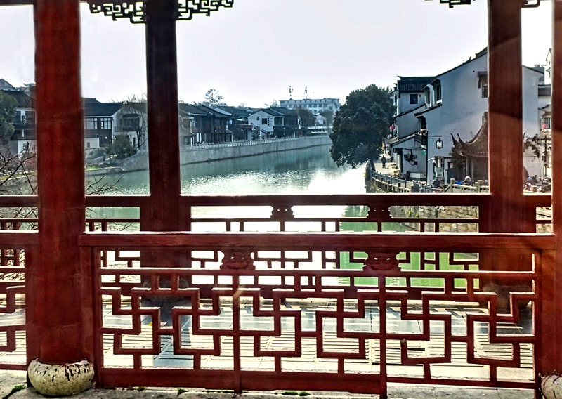
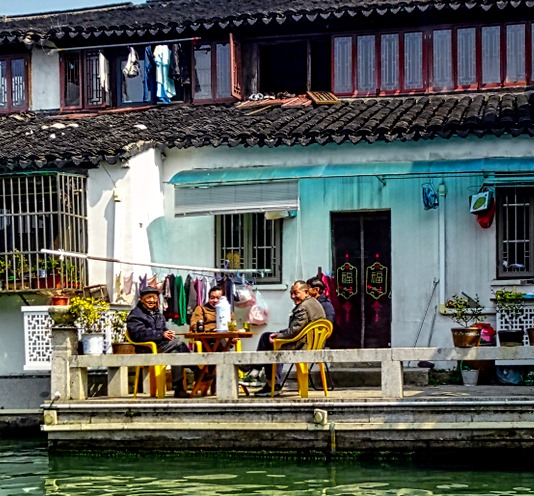
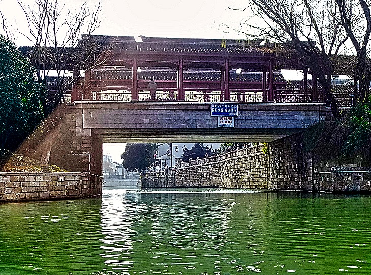
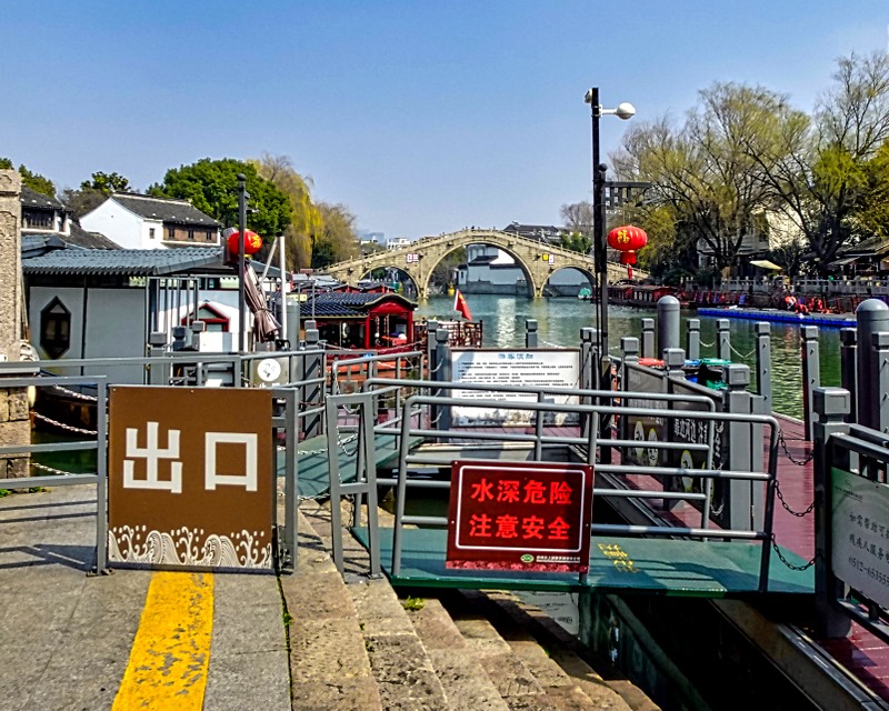
The section of the Grand Canal that runs through Suzhou is called the Jinghang canal. In Suzhou it runs along two sides of the old town outside what is left of the old city walls and served as a defensive moat as well as a transport route. We didn’t see that part, but we did have a boat ride along part of the canal after we left the Humble Administrator’s Garden. We had a nice walk through that part of town to the wharf where we boarded a long red river boat. Our walk crossed a couple of stone bridges and walked down a street lined with kite-looking fish above our heads.


")


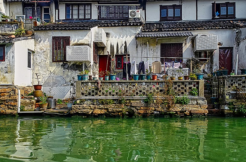
We understand that the stone bridges and whitewashed houses on the canal are several hundred years old. Many of the houses lack bathrooms (public bathrooms are available in the area) and many occupants wash their clothes in the canal. We went under an arched stone bridge and passed a number of the white houses, most with red lanterns hanging outside. At night these lanterns are lit up and there are lights on the bridges, which must give the area a romantic ambiance. Unfortunately, by the time night fell we were already at sea in the Zuiderdam.


The best spot for photography was outside on the front of the boat, but you couldn’t stay there because it would obstruct everybody else’s view. Rick walked up there once or twice to take some pictures, but mostly we were limited to photographing through the side windows where we were sitting, which only gave a view of one side of the canal.


Several smaller canals branch off the Grand Canal in Suzhou’s old town area. Marco Polo, who claimed to have visited here in the 13th century, called it the “Venice of the East.” From what we saw it doesn’t quite reach that height of grandeur, but you get the idea. Anyway, we passed several small stone bridges spanning intersections where these smaller canals branched off.


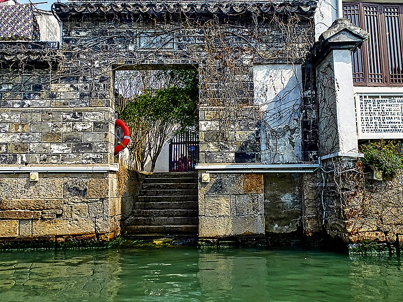
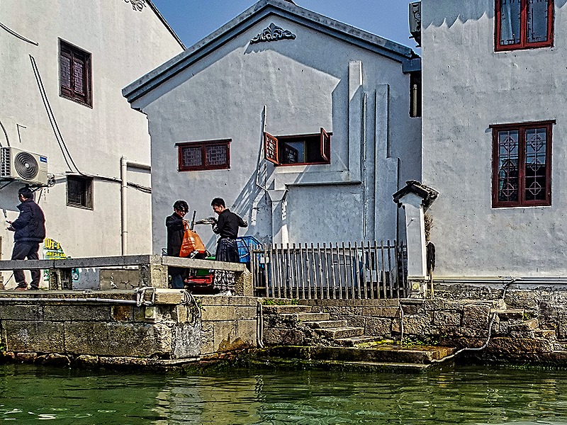
Many of the houses along the canal had porches or landings through which they interacted with the canal. Some had steps down to the water, some had laundry hanging by the water’s edge and some had other things stored on their decks.


")

 a tavern")


Most of the canal side buildings were houses of a similar plain, whitewashed design. But there were a few that were more elaborate (one looked like it could be a temple), and we also passed what looked like a family watching us from a park with steps down to the water.
")


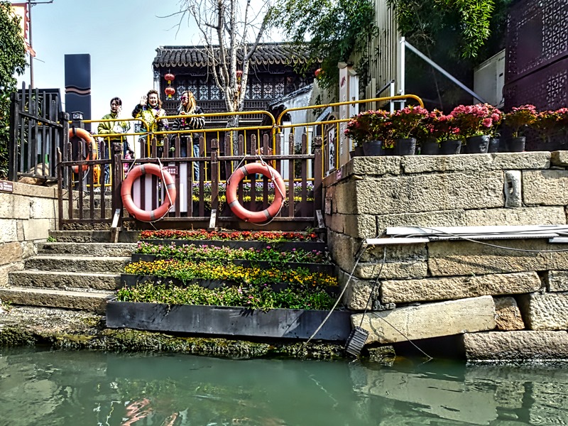
As we returned to the dock the canal opened into a much wider space. We went under a large stone bridge and passed a smaller wood and stone bridge leading to another branching canal. Walking back to the bus we had a nice view down another narrower canal lined with houses on both sides.


We had a Chinese lunch at a very nice hotel; the round tables had turntables in the middle for passing the platters. It is no surprise that here in the far east the streets are crowded with motorcycles and motor scooters. But it was a chilly day and the riders wore a kind of blanket with sleeves ending in oven mitts to keep warm while riding in the cold breeze. We had not seen anything like that before. When they left their scooters they just left these blanket things sitting there where anyone could make off with them. I guess that sort of thing is not done here.


After lunch we visited the Silk Embroidery Research Institute. Suzhou has been a center of production of silk embroidery for well over 2,000 years. Suzhou (or Su) Embroidery is one of four main types of silk embroidery in China, centering on subjects from nature, such as animals, birds and plants, although these days it is not limited to those subjects. Silk embroiderers in Suzhou use up to 40 different kinds of needles and 1,000 kinds of thread, dyed in a variety of colors. A single raw silk thread can be divided into up to 16 separate embroidery threads. One unusual Suzhou specialty is two-sided embroidery, which has a different picture on each side. Perhaps a white cat on front and a black cat on the back, or even a cat on the front and a dog on the back. Since both sides are visible, the ends of the silk strands are not knotted, but woven into the pattern in a way that makes them invisible to a viewer.
This embroidery is quite an art. We have read that even a very small silk embroidery takes about three months to complete, a medium size one takes a year and a large one can take three years or more. Many of these artists only produce about 15 works during their entire careers. No wonder they are expensive.
We spent some time in the work room watching the individual embroidery artists at work. We were told that to do this job you must have excellent eyesight but we wondered whether they still have that after doing this every day for a decade or two. The work was being done mostly by light coming from a large bank of windows and most of the embroiderers were working from a picture.


.")
After leaving the work room we were taken to a show room where a large variety of embroideries were for sale in many shapes and sizes and mountings, including some two sided ones. It was all quite dazzling but outside our budget, sadly, and many were too big to carry home on a cruise ship anyway. Unfortunately, photography was not permitted in the showroom.
Leaving the Embroidery Institute we boarded the bus for the long ride back to the ship, on which we sailed away at 5:00 (the early departure is why this excursion left the ship so early in the morning). We had a welcome sea day to rest up before our next stop in China.
Shanghai, China (Day 1) 2024
We arrived in Shanghai, our first stop in China, on the morning of March 7. Shanghai is a humongous city (25 million people, 3d largest in the world) located where the Yangtze River empties into the East China Sea. It has a long and colorful history dating back some 6,000 years. Starting out as a fishing village it became an important center for international trade in the mid-19th century, after the first Opium War, when it was one of five ports forced to open to European trade and European “concession” settlements. By the 1930’s it was a leading commercial and financial hub of Asia. Very cosmopolitan, Shanghai was a refuge for White Russians fleeing the revolution in the 1920’s and for Jews fleeing the Nazis in the 1930’s. During that period the city gained a reputation for danger and international intrigue. Indeed, since the 19th century, “shanghaied” was a term for drugging and kidnapping, stemming from the practice of filling out ship crews with abducted sailors. Shanghai was occupied by the Japanese during the second Sino-Japanese war that was a precursor of World War II, with great suffering. In 1949 it became part of the new Communist People’s Republic of China and its economy was rebuilt.
Originally we were scheduled to begin the Chinese leg of our voyage in Beijing. But obtaining a Chinese visa was somewhat challenging and it turned out that visitors who begin their visits to China in Shanghai can spend a few days there and in other coastal cities without having to get a visa. So HAL changed the itinerary a few months before we left Florida so we would start in Shanghai and end in Beijing (Tianjin). The caveat was that folks without a visa could only leave the ship on a ship sponsored tour, or one conducted by a government approved tour provider. Some folks went ahead and got a visa to visit places further inland, but we had never been to China before and wanted to spend our time in the port areas anyway. So we were happy for this change. Although some of our excursions here were conducted by our travel agency, those were treated as ship sponsored tours as well. Which was good because today we were scheduled for two of them.
We left the port early in the morning. Passing through customs was fairly slow and some people were redirected for additional scrutiny, although it seemed everybody we saw made it through eventually. For the most part Chinese customs was pretty bureaucratic and slow in all the cities we visited. It is possible for some cruise ships to sail up the river and dock downtown, but our ship was too large for that (it sure would be nice if HAL would prioritize using smaller ships for these longer journeys). So there was about an hour bus ride from our dock by the ocean to downtown Shanghai. Bus riding isn’t our favorite pastime, but there is something to be said for seeing the city streets as you drive along.
Our first stop was at the Jade Buddha Temple, opened originally in 1882 and rebuilt in the current location in 1928 after the original was destroyed during the revolution that overthrew the monarchy. As the name suggests, it was built to house two large jade Buddha statues, one reclining and one seated, that were brought here from Burma by a monk. This is an active monastery with dozens of monks on the premises, although we didn’t encounter any. The entrance is through a distinctive long yellow wall with red lanterns above it.

After entering we walked into a courtyard with buildings on several sides. An incense burner was at work in the middle and the eaves of the buildings were hung with red lanterns. The carefully sculptured trees in this area, trimmed to look like green clouds, were hung with red prayer tags. On the far side was the Great Hall, the main building of the complex.


If you look closely at the first picture in the group above, you will see a sculptured relief medallion on each side of the row of doors. They are very colorful. You should also notice the sculptural details on the ends of the rooftop.


This is one of the largest temples in China, with three main halls containing some 72 chambers. We did not have time to see most of that and the guidance we received was minimal and hurried. Thinking back, we are not even sure we saw the two large jade buddha statues that were the reason the temple was built, and even if we did see one or both of them photography was prohibited.
We did, however, walk through some of the notable chambers in the Great Hall. We walked through a room with three giant gold plated seated buddhas. On either side of this hall is a row of golden guardian deities, and we saw at least one row of these (we think). And there was a collection of dozens of small statues with a big one making up a single display, called “Guanyin, Sudhana and his 53 teachers.”

, Sudhana (to Guanyin's left) with his 53 teachers")


We mentioned that we have no pictures of the main sitting and reclining jade buddhas, but we did see a couple of smaller reclining buddhas in a different room (not sure which one). They were encased in glass in red and gold displays. On the left below are a photo and a closeup of the white reclining buddha (ceramic we think) and on the right is a photo and a closeup of the colored reclining buddha (jade, maybe?).


Another unidentified room contained a large plaque with a deity sculpted in relief, all shiny gold, and a room with rows of tables where people were writing, presumably prayers.


So we left the temple through the courtyard at which we began and headed for the bus (which took a while to arrive). Walking through the courtyard we passed a metal dragon urn, we saw some brightly colored sculptures on a roof and we enjoyed the patterns of the graceful upturned eaves of the roofs of the buildings.


We drove to our next place to visit, the Yuyuan Gardens. On the way we saw a variety of buildings from the window and we made a brief stop to walk over to a spot with a distant view of the very tall buildings lining the opposite shore of the Huangpu River that runs through the center of the city. We thought we would have a chance to walk along the river esplanade but we stopped well short of that. The skyline of the Pudong section across the river has some of the world’s tallest buildings and has become, in the last 20 or 30 years, a recognizable emblem of Shanghai. Notable in the pictures below are the 2,000+ foot high Shanghai Tower and the 1500+ foot high Oriental Pearl Broadcasting Tower.
 and commercial (below) block")


Yuyuan Gardens sits in the center of the old town, which was surrounded by large defensive walls that were built built in 1554 to protect from Japanese pirates (and torn down in 1912 to accommodate city expansion). The Yuyuan Garden was first built in 1559, just four years after the city walls. Pan Yunduan built the gardens to comfort his parents in their old age. But he was transferred away to be governor of Sichuan province, which delayed completion of the gardens until 1577. Over the centuries the gardens passed through several owners and were expanded, damaged and restored. In 1842 the British used it as a base during the first Opium War and during the Taiping Rebellion many of the buildings were damaged when the Small Swords Society used it as a headquarters. The gardens were damaged again in 1942 during the Japanese occupation of the city. The gardens were repaired in the 1950’s and opened to the public in 1961.
The gardens encompass five acres in six areas divided by Dragon Walls, which have undulating tops with dark tiles looking like a dragon’s tail and sculpted dragon heads at the ends. Very cool. There are passages through the walls between the separate areas, at least one of which is a moon gate.


The pavilions are mostly red in traditional Chinese style with roofs curving up on the end. Many of them sit next to landscaped ponds and are connected by curving covered bridges.


As you can see in some of the pictures above, landscaping rocks are an important feature of these gardens. Many were imported from distant lake areas and were used to build carefully designed “rockeries.” The most famous rock, considered the jewel of the gardens, is the “Exquisite Jade Rock,” around 13 feet tall and full of holes created by nature. It is said that the smoke from a burning taper placed under the rock will exit through all the holes in the rock.


And of course this is a garden, so it had a lot of very colorful flowers, although there would probably be many more later in the Spring or Summer. White ducks were swimming in the ponds.


Our time was too short to see all of the gardens (at least in the opinion of our guide, who seemed pretty rushed all day). We left through a gate with stone lions on each side and proceeded to the Yuyuan Bazaar. We had been told we would have free time in the old town, which sounded good, but it turned out that the place we had free time was a huge shopping mall right next to the gardens. To be sure, it was in the old town and it had some very impressive buildings with traditional Chinese architecture. We don’t know whether these are old buildings repurposed for shopping (possible, since this was in the old city area) or new buildings designed to look like old ones; either way they were interesting to see. But still, a shopping mall was not what we were hoping for. We must have spent at least an hour there; we looked through some interesting stores but the prices were high and we didn’t see anything that called our names. We understand that these buildings are dramatically lighted at night, but we weren’t here then.


 walking down a crowded street lined with shops on both sides")


The long drive back to the port left us just enough time to eat dinner in the LIdo buffet and get ready to board another bus for our evening excursion, a boat ride on the Huangpu River lined with lighted buildings, near where we had spent the afternoon. This river is some 70 miles long and flows into the Yangtze just before it enters the ocean. It has been a commercial backbone of the city for centuries, reputedly assisted by some engineering during the 16th century that enabled water from a lake to flow into the river near its source. This is hardly the Amazon, but it is a sizeable river: in Shanghai the river varies between 1,000 and 2,500 feet in width and averages 30 feet deep. On its west bank is Puxi (the old city) and on its east bank is Pudong.

We arrived at the terminal on the west bank at about sundown and the nearby buildings were already lighted.


We spent a good bit of time winding through the long line for admittance to the dock. It was actually a fairly long walk, including some stairways. By the time we reached the dock the sun was down and we walked down the dock to board the boat. On a tip we went upstairs and right to the back of the boat, where we had the best view of both sides of the river during the entire cruise, which lasted close to an hour.

Along the riverfront on the west (old city) side is a mile long row mostly of 100+ year old buildings called the Bund (sounds German, but actually from a Hindi word for embankment). There is a wide concrete promenade between the buildings and the river. This was the financial center of Shanghai in the 1920’s & 30’s when Shanghai was a financial center of Asia. The architecture here is stolid European style, reflecting the power of the American and European concessions that were located behind it. In the 1950’s many of the banking institutions here moved to Hong Kong. This area was restored about 15 years ago.
So here are some pictures (handheld from a moving boat at night, so many are not entirely clear). We will try to identify each building as best we can.
— First is a panorama of the Bund shoreline.
–The Second shows the old Hongkong & Shanghai Banking Corp (HSBC) building (built in 1923) and the Customs House (1927) (the clock and tower were built in England and copied from Big Ben).
–The third picture includes (from left) the China Bank of Communications Bldg (built in 1948) now housing the Shanghai Council of Trade Unions; the Russo-Chinese Bank Bldg, now the Shanghai Gold Exchange; the Bank of Taiwan Bldg, now the China Merchants Bank; the North China Daily News Bldg, now AIA insurance; and the Chartered Bank Bldg, now home to several businesses.


–The large building in the first picture below is the Bund Center, with its easy to see lotus flower crown brightly lit, a little way back from the riverfront. It was built in 2002 and is 659 ft tall. The building on the lower right is the Telegraph Building, in middle is the China Merchants Bank and at the lower left is the Nissin Navigation Co. Bldg (more info on these below).
–The second picture below shows it again, with a larger building in front sporting a red pyramidal roof which we haven’t been able to identify.


–The first picture below includes (from left) the North China Daily News Bldg; the Chartered Bank Bldg; the Palace Hotel, built in 1906, which was one of the best hotels in Shanghai until 1949, when it merged with the next building to form the Peace Hotel. That building, originally called Sassoon House, with its distinctive green pyramidal roof, was built by tycoon Victor Sassoon in 1929 and had a famous jazz band in its cafe (which can be seen again today). The tall rectangular building on the right is the Bank of China Bldg, built in 1937 by H.H. Kung, a rival of Sassoon’s. Its height was cut short because of Sassoon’s insistence that no other building on the Bund could be taller than his. Rivals indeed.
–The second picture below is of the Shanghai People’s Heroes Memorial Tower, built in 1993 and located in Huangpu Park. To its right you can just barely see the Waibaidu Bridge, lit red like the Memorial, crossing Suzhou Creek. Built in 1907, it was the first steel bridge in China.
–The third picture below shows (from left): the Shanghai Club (we think), built in 1910; The Nissen Bldg, built in 1925 by a Japanese shipping company; the China Merchants Bank Bldg, home to the first Chinese owned bank in China; and The Great Northern Telegraph Bldg, which in 1882 had the first telephone switch in town. In the distance on the right with the white spires is the Shimao International Plaza, which is more than 1,000 feet tall and opened in 2006.


Hard to see in the dark, but there were some parks near the river, one with what looked like a brightly lighted dragon, and some other excursion boats on the river.


")
On the east bank of the Huangpu the waterfront of the Pudong New District is called Lujiazui. It occupies a peninsula where the river bends. The area was mostly farmland, warehouses, factories and commercial wharves until 1990 when China began developing it into a financial and commercial center. Today it far outshines the older and smaller buildings of the Bund across the river in both the size and modern design of the buildings along its skyline. Probably few will fail to recognize at least some of it. At night it is illuminated with brightly colored lights. While we don’t know the names of most of the Pudong buildings, we can tell you that the four tallest buildings in Shanghai, and among the tallest in the world, are there: The 1,400 foot Jin Mao Tower (1999), the 1,600 foot Shanghai World Financial Center (2007), the 2,000+ foot Shanghai Tower (2015), and the almost 1,500 foot Oriental Pearl (Broadcast) Tower (1995). They aren’t hard to spot in the pictures . . . The Shanghai Tower is obviously the tallest, the Jin Mao Tower is shaped like a very tall pagoda with a pointy roof, the World Finance Center has a large hole in the top, looking like a giant beer bottle opener, and the Oriental Pearl is made of struts and spheres. But we will name them in the picture captions (which you can see on a computer by hovering your mouse over the picture).


: Tallest builoding is the Shanghai Tower, with the Citi Bldg to its left, the Jin Mao Tower behind with pink top, and the Aurora Plaza (which we saw in the afternoon looking gold) with a giant video screen.")


So these river banks are bright and shiny kaleidoscopes of light and color, a pretty spectacular sight as we cruised up and down the river. But that’s not all: some of them continuously change their lighting pattern as the show goes on. Below is a good example of this, the 1.000+ foot White Magnolia Plaza, which opened in 2017. It is on the Puli side of the river, slightly up river from the Bund. Here are four pictures of it showing its changing light presentations (though always with a golden roof).


Well this was quite a lot for one day exploring Shanghai, particularly since it included 4 one hour long bus rides to and from the dock. But this is a city with quite a lot to see and we hardly scratched the surface. We drove back to the ship and went to bed, because our excursion for the second day in Shanghai leaves at 6:30 AM. Yikes!
Kanmon Strait & Fukuoka, Japan 2024
Kanmon Strait
On March 4 we sailed through Kanmon Strait. Kanmon Strait is a narrow water passage dividing the Japanese islands of Honshu (home of Tokyo and Kobe) and Kyushu (home of Fukuoka), two of Japan’s main islands. There are cruise ports in this strait but we didn’t stop at any of them. This was listed on our itinerary as “scenic cruising,” and while we were certainly cruising there, it was really not very scenic. But the route from Kobe to Fukuoka took us through here and the shore was visible on both sides of the ship, so there you are.
Two cities line the shores of Kanmon Strait. Kitakyushu, a city of about a million people, sits on the Kyushu side, and Shimonoseki, with a population around a quarter of a million, is on the Honshu side. Sailing into Kanmon from Kobe, Kitakyushu was to port (left) while Shimonoseki was to starboard. Our cabin was on the starboard side of the ship and we watched from our veranda as we sailed through the strait, so we only saw Shimonoseki and the Honshu shore, and that’s where all of our pictures are. We have read that western style lighthouses were erected at both ends of the strait in the 1860’s when Japan was opened to foreign trade. We don’t know whether it was one of the originals, but a lighthouse was the first thing we saw as we approached the Strait.


While these modern cities are less than 150 years old this area has a long history. In 1185 it was the scene of a decisive naval battle (Battle of Dan-no-ura) in the Genpei War in which the emperor, Antoku, was killed and the Minamoto clan established the first shogunate. In 1863-64 it was embroiled in the struggle between the supporters of the shogun, who had opened some Japanese ports to foreign trade, and those of the emperor, who had ordered all “barbarians” expelled from Japan. Several naval engagements between Japanese and Western ships were fought here and the town that grew into Shimonoseki was bombarded.
During the final months of World War II US bombers dropped some 5,000 mines into and around the strait to cut off Japanese transport between Honshu and Kyushu (and between the Sea of Japan and the Inland Sea). About 3500 of those mines have been recovered and destroyed since the end of the war but hundreds are still there, unlikely to explode because of decades of deterioration but still containing dangerous explosives. Just two months before we arrived here one of them was recovered and safely detonated. Finally, the city of Kokura, now part of Kitakyushu, was the original target for the second atomic bomb in 1945, but because of dense cloud cover (some natural and some created by workers burning tar and releasing steam) the mission was diverted to Nagasaki.
As we sailed along we saw small towns, or maybe suburbs, among green hills. Although our cruise director, Kimberly, narrated as we sailed through the Strait, we couldn’t really understand because we were sitting on our veranda and only heard her from muddy sounding deck speakers (must be the speakers, it sure couldn’t have been our ears, I am sure). So we can’t tell you anything about these neighborhoods.


At one time travel across the strait was limited to ferries. There still are ferries operating here but now most of the traffic is by tunnel. The first railway tunnel was built in 1942 and the first highway tunnel opened in 1958. Other tunnels followed. In 1973 the Kanmonkyo Bridge between the islands began carrying cars and trucks. We sailed under this bridge, which is a white suspension bridge with a central span of about 3500 feet.


Most notable as we passed the central area of Shimonoseki was what looked like construction or repair of a Torii gate near the shoreline. We looked closer and it appeared that there was a steep staircase up a hill covered by a long series of red Torii gates. Usually if you see a Torii gate there will be a Shinto shrine nearby. We couldn’t spot one, but we assume that is where this stairway led. We also passed an amusement park on the waterfront with a large ferris wheel. In the distance behind it was what we think is the Kaikyo Yume Tower, about 500 feet tall, which opened in 1996. And we passed a solar energy farm separating a housing neighborhood from the waterfront.


We sailed on past the city, passing a final peninsula (or island?) as the Strait opened into the Sea of Japan.

Fukuoka, Japan
We woke up on the morning of March 5 in Fukuoka, our last port in Japan. It was another gray and wet day, but we were booked on an excursion.
With a metropolitan population of about 2.5 million people, Fukuoka is the largest city on the island of Kyushu. Its strategic location on Hakata Bay, relatively close to mainland China, made it a center for international trade even in ancient times . . . and also a convenient target for invasion. Kublai Khan mounted two unsuccessful invasions in the 1270’s. After the first attempt in 1274 the local samurai built a wall along the waterfront some 12 miles long and 5 to 10 feet tall with a base about 10 feet thick. Five years later a Chinese delegation was beheaded after demanding Japanese submission and in 1281 Kublai Khan sent a large army in 4,000 ships to Fukuoka. The Japanese were not strong enough to resist this invasion. But the invading forces were stopped by a major typhoon that sank many of their ships. The Japanese called this the “Divine Wind” – Kamikaze in Japanese, a label applied to Japanese suicide pilots near the end of World War II. The modern city was formed in 1889 from the merger of the cities of Hakata (still the name of the bay) and Fukuoka.
Since all-aboard time was at 3:30 our excursion set out early, around 8:30. Our first stop was Dazaifu Tenmanga Shrine, 9 or 10 miles away. The shrine was a bit of a walk from where our bus parked, up a commercial street lined with shops and cafes. We walked past the Dazaifu train station, built in 1902 when the only vehicles traversing the tracks were still drawn by horses. One storefront was one of the best known of the countless Starbucks in Japan. It is decorated with kigumi woodwork, a traditional Japanese building technique in which the wood is connected by slots and no nails or other metal supports are used. We didn’t have a chance to enter this store, as it was not open, but the green Starbucks sign among the wood posts caught our eye.


Dazaifu Tenmangu is a Shinto shrine dedicated to Tenjin, the deified name given posthumously to Sugawara no Michizane, a monk who died in 903. He was a poet and scholar who rose to prominence at an early age but was exiled to Kyushu when he lost favor with the ruling clan. He spent the rest of his life studying and died at the age of 57. Michizane’s body was carried by oxcart for burial, but the ox stopped in the road and refused to go any further. So his followers buried him on that spot and erected a shrine over his grave in 905. The current shrine was built in 1591 on the spot where Michizane is buried and, although there are some 12,000 Tenjin shrines throughout Japan, this is considered the primary one.
The shrine’s grounds cover more than 3,000 acres and, as usual with Shinto shrines, you enter through a Torii gate with several more as you walk through the grounds. A number of stone lanterns also line the path.


The story of the stubborn ox has led to many offerings of ox sculptures, eleven of which are prominently displayed on the grounds. Called shingyu, many have shiny bronze heads because patting the ox is supposed to grant wisdom and these have been patted every day for centuries.


The path toward the main shrine area took us across a beautiful pond by way of a three part red bridge, the first and last of which are arched. These three sections are said to represent the past, the present, and the future. At the top of the first arched bridge you can see back to where you walked from; on the flat central bridge representing the present you can see neither what was behind nor what is ahead; on the third arched section you can see forward to the central shrine complex. In the pond are islands, fountains, birds and fish.


Back on the path we walked under another torii gate to get our first full view of the two story Romon gate to the inner shrine compound. Off to the right of the torii gate are several structures, including a colorful well and a bronze sculpture of a Kirin, a mythical beast with the head of a dragon and the body of a deer or a horse. Several pairs of Komainu sculptures, protective creatures that are part lion and part dog which were called Shisu in Okinawa, are on the grounds as well.


We entered the central courtyard through the Romon gate. On the opposite side is the Honden, the primary sanctuary that was built over Michizane’s grave in 1591. Unfortunately we were unable to see it because it is covered in construction cloth for a renovation project (the first in 120 years) that will not be finished for two more years. There was a poster with a picture of it nearby, and a temporary structure, with a garden roof, has been set up in front of it to accommodate prayers.
You will recall that Michizane was a venerated scholar and he is is now considered the primary deity of learning and wisdom. This shrine is a popular place to pray for academic success and is particularly crowded at exam time. A group of students came to pray in front of the Honden while we were there and hopefully passed their exams. In front of the Honden was a large rack of small hanging wooden cards. These are called Ema and can be purchased for less than a dollar apiece at a nearby kiosk. You write a wish or prayer on it and hang it on the wall to submit the prayer.


Plum trees were reputedly Michizane’s favorites and there are more than 6,000 of them, in some 200 different varieties, on the grounds of his shrine. The most famous is the Tobiume, the Flying Plum. The story goes that this tree was Michizane’s favorite when he lived in Kyoto and after his banishment to Kyushu this tree missed him so much that one night it flew to his grave. If so, it would be more than 1100 years old by now. It is said to be the first plum to bloom in Japan each year. There are so many trees here it is difficult to keep straight which is which, especially with the construction site making much of the area hard to recognize from pictures. The Flying Plum sits just to the right of the Hondo entrance in the poster picture above and we think we found it, jutting out just in front of the construction curtain in that area. If it is the first to bloom, at the beginning of February, its blossoms may already have gone by when we were there because there are none on the tree in this picture. Other trees in the courtyard were in bloom, however.


This shrine is also known for its ancient camphor trees. Two of them, situated near each other, are said to be “married.” And one big gnarled one is said to be 1500 years old. We don’t really know whether the large trees we photographed are those, but they might be. The rack of red gourds on the left in the first picture are for depositing paper prayers.
 in the back of the Honden on the side where the Flying Plum sits")


We left as we had come, out through the Romon gate (which is unusual because it has two roofs on the outside, but only one roof and a balcony on the inside), down the path under the torii gates and over the bridges, then back down the commercial street to where we left the bus.


Leaving the small town of Dazaifu we drove to our next stop . . . another shrine. Located in the heart of Fukuoka, the Kushida shrine is believed to date back to 757. But it was rebuilt in 1587 under the sponsorship of Toyotomi Hideyoshi, who also built the Osaki Castle we saw a few days ago. It is dedicated to three deities: Amaterasu (sun goddess), Susanoo (her brother and god of storms), and Okuninushi (Susanoo’s son and god of agriculture and medicine). This shrine is considered the protector of Fukuoka.
Entering through the Sakuramon gate just inside the torii gate near the street, we walked under a large red lantern hanging in the middle and a round chart of the Chinese zodiac, called Etoehoban. Every New Year’s eve they rotate the pointer in the middle to point to the new year’s zodiac animal, indicating which direction will be the lucky one that year. A pair of Komainu flank the sides of the entryway.


To the left of this gate is a huge Gingko tree that is said to be more than 1,000 years old. There is a yellow skirt around its trunk and displayed in front of it is a long stone said to be salvaged from one of Kublai Khan’s ships sunk by the Divine Wind in 1281, as discussed at the beginning of this episode. At the time of our visit the tree was still bare of leaves but we understand that during spring and summer it is very lush and green and in autumn it turns bright yellow.


Once we passed through the main gate we came to an inner gate that led into the courtyard of the main shrine (Honden?) at the end.


The courtyard is quite busy with flora and sculpture. There is a large statue of a horse and a small well for praying for eternal youth, guarded by sculptured cranes (which is said to produce salty water from a natural underground source). Some cherry or plum trees were in bloom when we visited. We passed a couple of young women in kimonos (probably rented) walking past an elaborate metal lantern.


There were two tunnels made of torii gates all in a row, which we think led to auxiliary shrines. One was wooden with most of the torii gates painted orange or red, and the other was stone. Nearby was a building displaying what appeared to be small religious artifacts, with Komainu guarding on both sides.


The shrine has a display of Chikara Ishi, large stones used for power lifting. This practice dates back more than 1200 years, and it has had religious, muscle training and competition uses over the years. Sumo wrestlers are known for lifting these heavy stones. We also saw a rack of sake barrels donated by various breweries, which we have seen at other shrines, because the Shinto religion considers sake to be the drink of the gods. And there was a Hakata-bei wall built in the 16th century. These earthen walls with salvaged rubble embedded in them were very popular at that time because of the widespread destruction from civil wars but only a few of them are left.


We walked through a side entrance to the courtyard that was hung with a large yellow lantern. On display outside were two floats from the Hakata Gion Yamakasa festival held every July for almost 800 years. Floats like these, which are built anew every summer, are raced through the streets carried (or dragged) by groups of men from seven neighborhoods in the Hakata district wearing loincloths. There are two kinds of floats, stationary ones and smaller mobile ones; we are not sure but think the ones on display here are two of the stationary ones set up around the racing streets. They are about 30 or 40 feet tall and are brightly colored, with figures of horses, samurai, buildings and dragons, which we have read are fashioned from papier mache. The mobile ones weigh about a ton. We also saw the golden Mikoshi portable shrine through a picture window in a building, with two scary dog(?) masks sitting in front of it. A portable shrine is for transporting a god when it leaves its shrine and in October, during the Hakata Okunchi festival, this one is hitched to an ox and paraded in procession around the streets of the Hakata district.


Leaving the shrine, we drove through the rainy streets of Fukuoka to our last stop, the Fukuoka Tower at the seashore. On the way we passed the Mizuho PayPay Dome, the home of the city’s professional baseball team, the Fukuoka Softbank Hawks. It was built in 1993, has 40,000 seats and until last year was the only stadium in Japan with a retractable roof.

Opened in 1989, the Fukuoka Tower is, at 768 feet, the tallest waterfront tower in Japan. Its circumference is triangle shaped and it is covered with 8,000 one way mirrors, reflecting the sky from outside but allowing a view of the outside for those inside. Our first view of the tower was through the raindrops on the bus window. We rode a fast elevator to the observation deck almost 404 feet above the street (the other 350 feet of height is a television broadcasting antenna). The elevator is the only thing inside the tower until you reach the observation decks.


It is quite a view from the observation deck. Following the beach toward our right we could see the Hakata port in the far distance and behind the yellowish building is the baseball stadium. The panorama to our left was broken by the Muromi river flowing through town, with a tiny corner of the public library at the far left of the picture (if we had known at the time that this was the library there would be a better picture of it). Looking down in front along the beach was a group wielding umbrellas (yep, still raining) and on an artificial island in front of the tower was the Marizon at Momochi Seaside Park, which includes upscale seaview restaurants and a bridal chapel.
")


")
So that’s the end of our visit to Fukuoka, from which we sailed away in mid-afternoon, and of Japan. But its not the end of our voyage, so there is plenty more to come.
Kobe, Japan (Day 2) – Osaka (2024)
As always seems to happen when we have an overnight stay, we woke up on the morning of March 3 still in Kobe harbor. Today we had scheduled an excursion to Osaka, a lengthy bus ride away, on which we left early in the morning. With a population of about 2.7 million, Osaka is the third largest city in Japan and is a major commercial and financial center for the country. It is home to important international electronics companies like Panasonic and Sharp. People have lived here for at least 2,000 years, one of the earliest settlements in Japan. Like other Japanese cities, Osaka was subject to extensive Allied bombing near the end of World War II but was successfully rebuilt after the war.
It would be difficult to plan a visit to Japan without including visits to temples and shrines. Our first visit today was to Shitenno-ji Temple, considered by many the oldest Buddhist temple in Japan. It was first built in 593 by Prince Shotoku, one of the first to promote the spread of Buddhism here. Its buildings have been destroyed many times, by both war and natural calamities, most recently by the bombing in World War II. The current reconstruction, based on archeological excavations as well as old records, was completed in 1963 and is considered to be as true as possible to its original appearance.
The temple’s core consists of a covered walkway around the main courtyard, with a gate on one side and a lecture hall (Kodo) on the other. In the courtyard are the Kondo (the main hall) and a five story pagoda. The predominant colors of the buildings are red and white. The buildings are aligned in a straight line – Chumon gate, pogoda, kondo, Kodo – an arrangement that came to be known as Shitennoji-style and was widely copied.


The five story pagoda is easily the most prominent building in the temple complex. Each floor reputedly contains a different set of religious artifacts. I say reputedly because, although entry was permitted if you removed your shoes, we did not climb the stairs here. Really not enough time. But Rick walked up the concrete stairs and took a photograph of the interior through the door.


We have read that there is a market at this temple every month on the second or third weekend. But we were there on March 3 and there definitely was a lively market inside the gates, with many people selling crafts, clothing and other things from temporary looking cloth roofed kiosks held up by poles. Our guide said this occurs every Sunday. So maybe this isn’t the official big time market scheduled once a month, but it certainly occurs on Sundays (at least the Sunday when we were there).


The Kondo is the main sanctuary sitting in the middle of the courtyard, but it was closed the day we were there so we didn’t see the inside. We also have pictures of two interesting buildings we can’t identify, one with a hexagon shape and a gold looking figure on the apex of the roof and another that is mostly red and white, with a surrounding porch sitting on short pillars.


Our next stop was Osaka Castle. On our way there we passed a couple in a park teaching their son how to wield a baseball bat (baseball is, of course, very big in Japan). We parked in a lot a good bit away from the castle and had a long walk, through woods and along moat walls, to get there.


Osaka Castle was originally built in the 1580’s and 90’s by Toyotomi Hideyoshi. The Toyotomi clan were the primary rivals to the Tokugawas for the office of shogun, the military leader and actual political ruler of Japan. If you have read or watched James Clavell’s historical novel Shogun, you will recall that much of the action takes place in Osaka Castle and Toyotami is an important character (under a fictional name). In 1600 Tokugawa Ieyasu became shogun. In 1614-15, after a siege, the castle fell to the Tokugawas and while Hideyoshi had already died, both his son and his widow committed suicide, ending the Toyotomi clan. The castle was burned to the ground.
In the 1620’s the Tokugawas rebuilt the castle, burying what was left of Toyotomi’s castle and building new stone walls (still standing) and a new tower on a different spot near where the old one stood. Most of the castle’s buildings were destroyed and rebuilt several times over the centuries, most recently by Allied bombing near the end of World War II. The current version, restoring the castle largely to its Tokugawa era appearance, but with more reliable modern materials, was completed in 1997.
On our way to the castle we passed a small Shinto shrine called Hokoku-jinja. It was built by the Meiji emperor in 1879 to honor the Toyotomi clan. We did not go into the shrine, but we did see the torii gate at its entry and a statue of Toyotomi Hideyoshi erected in 2007, which faces the castle. He does not look warm and cuddly.


Walking around the moat we saw a white watchtower above the stone wall on the opposite side. We didn’t notice it at the time, but through the bare trees behind the watchtower the green roofs of the castle tower were just visible in the distance.


This was a weekend and it was early afternoon when we reached the castle, so the area was quite crowded. The castle is white with green roofs and decorated in gold. It is five stories tall from the outside, but 8 stories on the inside. We had to wait in a long line for quite a while to gain admittance.


There is an elevator inside (as mentioned, this is a modern concrete replica, not the original wooden castle), and the easiest way to see the castle inside would be to take the elevator to the top and walk down the 8 flights of stairs. But the elevator is slow and so many people want (or need) to use it that the wait is substantial and we didn’t really have extra time to waste standing in line. So we walked up the 8 flights of stairs. The castle today is really a museum with exhibits on each floor. Here is an exhibit of ancient Japanese war helmets on one floor, one of which was marked as having belonged to Toyotomi Hideyoshi. For a fee you could don one of these helmets along with some armor to have your picture taken. Also on exhibit was a life size example of the golden dolphin and crouching tigers that adorn the outside of the castle. There were many more interesting exhibits, including large paintings, that were difficult to examine because of the crowds in front of them.


In the end we reached the top floor, which had viewing windows all around with fabulous views of the surrounding area and the gold dolphins adorning the the top of the roof just below. The entire area was screened in and you could see the screens from the ground outside. We looked down on the moat where visitors could ride in a boat (a moat boat?). In one direction was a cityscape of skyscrapers and in front of the castle we looked down on the grounds of the entry area. The view was worth the walk up the stairs.


We returned to the ground floor down the stairway (there are separate up and down stairwells, which undoubtedly helps the traffic flow). As we walked back to the bus we had a last view of the castle with its nicely landscaped grounds and also another view of the moat boat, this time sailing down the moat. We ate lunch at a nice hotel, happily a sit down meal rather than a buffet line, where the Japanese food was interesting, tasty and beautifully presented.


After lunch we were dropped off at the beginning of a district called Dotonbori (or Doutonbori) and told to meet back there in an hour or so. This neighborhood began in 1612 with the building of a canal on what was then the southern edge of Osaka. The canal was completed in 1615, after a delay caused by the Siege of Osaka. It was named after one of its designers, Nariyasu Doton, who had died fighting for the Toyotomis during the siege. The Tokugawas designated this as Osaka’s entertainment district and by 1662 it had 11 theaters and a mechanical puppet show, along with restaurants and cafes built to serve the entertainment crowds. However, over the centuries the district declined and during World War II all but one of the remaining theaters were destroyed by bombing. In the 1960’s the canal was renovated and in the early 2000’s the streets lining the canal were redeveloped.
Today this is a bustling area with large crowds patronizing cafes, restaurants and commercial stores, many located inside a large covered mall. We walked along the canal looking, but not stopping in, a large variety of stores and restaurants.


 lining its facade")
As you can see, the canal is lined with rows of commercial buildings of all types. Most notable are the colorful signs, many outsized, eye catching and even mechanical. For example the giant crab above the Kani Doraku restaurant moves all of its arms.


We came to a covered shopping mall, which we spent some time walking through. Lots of stores and restaurants in here too and it was really crowded.


Walking back down along the canal we saw more unusual commercial signs, some very large and surely quite expensive. We also walked past street decorations, one of which was a manhole cover with the Osaka castle and cherry blossoms on it.


Well, this was all quite interesting in an over-the-top sort of way. We have seen this neighborhood likened to the street scenes in the movie Blade Runner and there is certainly that kind of flavor to it (although we understand that those movie scenes were actually inspired by a district in Tokyo). It must be quite exciting at night when all the neon lights are on, but of course by night time we would be at sea. Still, pretty impressive that this area attracts such crowds even in the early afternoon, although it was a weekend.
We met our bus and drove back to the port. Our veranda was perfectly situated to watch the farewell festivities mounted by Kobe on the roof of the terminal right by the ship. We were serenaded by the Kobe Hardi Wind Ensemble (which we know because it was printed on the white tuba), although only about half the musicians were actually playing wind instruments. They were a “hardi” group indeed who were bundled up against the cold but were still there playing when we left the dock. At one point pink, white and green balloons were released into the air and there was a fellow nearby waving what looked like naval signal flags, whose meaning we do not know (but we would guess something like “farewell”). Families and children were there as well, many carrying balloons. As we pulled away from the dock they struck up “Anchors Aweigh.” Much fun and a great send off.


We sailed out of Kobe harbor as the sun was setting, getting a last look at the city skyline in the harbor area and passing two nice bridges before seeing a nice sunset as we reached the ocean. It had certainly been quite a full and rewarding couple of days.


