
Korcula, Croatia
On April 22 we arrived off Korcula, the last of our medieval walled cities on the Dalmatian coast. This was a tender port (ie. the ship is anchored and passengers go to and from the port by tender boat) and it was also a short day, with all aboard scheduled for 1:30. But we found this to be more than enough time for this small town, particularly since almost everything in the old city was closed for the off season (sadly, we were about 9 days too early for the start of the season). Korcula is another walled city on a small isthmus with orange terra cotta roofs & has been called a mini-Dubrovnik. This might have been a little more exciting if we had not been to the actual full sized Dubrovnik only 2 days earlier (and it might have been more interesting if the museums had been open and the Cathedral hadn’t been covered in scaffolding). Still, it was an interesting city to explore & we had a pleasant time (except for the cold weather).

Unlike many medieval cities, Korcula was built according to plan. It is shaped like a horseshoe crab pointing out from the land. The streets are laid out in a sort of herringbone pattern, with a main road running from the main gate toward the rounded point of the crab & rows of fairly straight side streets branching off at a bit of an angle in each direction. It is said that this plan was designed to protect from the harsh south winds but let in the pleasant north winds. Founded by the Greeks in the 4th Century BC, Korcula was later part of the Roman Empire and later was ruled by Venice for a number of centuries. It was part of Yugoslavia after World War I and again after World War II, and is now part of the independent Croatian state.
We entered Korcula by the 15th Century Land Gate, an impressive introduction with a grand stone staircase leading over what once was a moat-like canal to a large crenellated tower. This Revelin Tower has a relief of a Venetian lion of St. Mark flanked by the coats of arms of the Doge of Venice on the left and the rector of Korcula on the right.


 & rector's (r); the one below on the left is of the rector at the time the tower was renovated")


The inside of the gate was more elaborate than the outside & the tower was topped with a picture window (it was closed for offseason, so we couldn’t go up to see the view). To the left of the gate after entering is the 16th Century Rector’s palace, which had a nice loggia and a large stone plaque of the lion of St. Mark leaning against a wall. Nearby was an interesting shrine and on the right was the 14th Century Church of St. Michael. Apparently it was believed that a church dedicated to St. Michael inside the town gates would help ward off enemies. The stone overpass to the left of the church leads to the building of the Brotherhood of St. Michael.


We walked on to St. Mark’s Cathedral, the highest point in town. You can see it atop the city looking like a birthday candle on a cake in the first picture. Unfortunately, the cathedral was covered in scaffolding and canvas so we didn’t get to see what it looks like. We went in but no photography was allowed. Across the street is the Gabriellis Palace, which now houses the town museum (closed for offseason, of course).


The last real landmark in Korcula is the so-called Marco Polo’s house. Korcula claims the Marco Polo was born here in 1254, but there is no actual evidence that this is true and it is disputed by historians, who seem to think he was most likely born in Venice. As we have seen elsewhere, however, Korcula has a house claimed to be his birthplace (although it was apparently built a little too late for that) for tourists to pay to visit (but not in offseason). It is an imposing tower of a house with some lovely ruins attached, so it is worth seeing if you are in town whether Marco Polo ever lived there or not. Marco Polo does have a documented relation to Korcula, however. In 1298 he was captured by the Genoese in the Battle of Korcula, a sea battle in which he commanded one of the Venetian ships. While he was a prisoner of war in Genoa Marco Polo and another prisoner collaborated on the book about his travels to China that became something of a sensation (although few believed it at the time) and helped inspire Christopher Columbus to try to sail to China almost two centuries later.


")

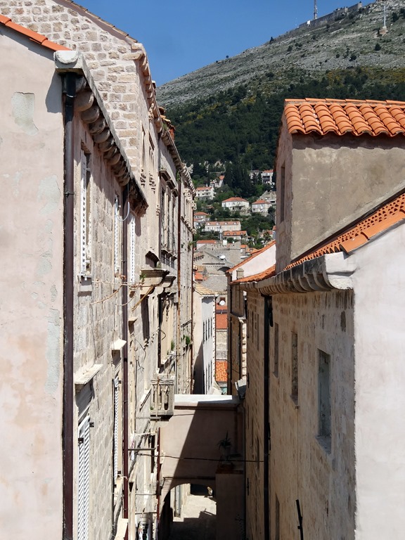
While its streets aren’t maze-like, they are picturesque as in the other Dalmatian cities: narrow and often with arches and stairs.


This is, or at least was, a walled city. The town walls were built at least by the 13th Century, but they were extended and the fortified towers built over the next few centuries by the Venetians (each tower has a plaque of the lion of St. Mark). In the late 19th Century, when the Ottoman threat had long passed and Korcula was no longer a strategic outpost, the Korculans took down the top half of the walls to use for new buildings. But the walls with their massive defensive towers still make a substantial impression.


Outside the walls the city is surrounded by mountains, which were largely covered by clouds the day we were there. There is also a nice strip of waterfront with palm trees (Korcula is actually further north than New York), boats & an interesting monument with reliefs from the era of Socialist Realism.


So that was all for this very short port day, & we returned to the ship. Our friend Jerry (who took the picture of us by the stairway) was returning at the same time and was carrying an expensive SLR camera he had been given by the proprietor of a café where another passenger had left it. An impressive bit of honesty by the proprietor — since no one knew who it belonged to & the ship was getting ready to leave no one would have returned to ask him for it. Jerry did eventually discover the identity of the camera’s owner by pure serendipity (she was standing at the front desk of the ship when Jerry went to turn it in). She was very lucky! Anyway, we sailed away from cloudy & chilly Korcula and the Dalmatian coast to our first stop in Italy, Venice.

Kotor, Montenegro
We pulled into Kotor early in the morning of April 21. We had been told to be sure to arise early for our sunrise sail-in through the beautiful bay of Kotor, but we were tired from Dubrovnik & decided we need our sleep. Luckily for us our entry into the bay was delayed because the port authorities unaccountably gave preference to another cruise ship (our captain was quite irritated). I say luckily for us because this enabled us to see most of the sail-in, which really was stunning. There were rugged mountains surrounding the water, which was uncommonly still and reflective in the morning sun, and picturesque villages lined the shore. Often called the southernmost fjord in Europe, this is not really a fjord but a river canyon that has been submerged by the sea.
 in the bay of Kotor")


")


In the bay, near the village of Perast, are two islands. The tiny Island of St. George (I am using the English translations, obviously) is surrounded by a dozen Cypress trees and houses a Dominican monastery that has been in operation since the 12th Century. More interesting is the nearby Our Lady of the Rock, which is man made. It seems that on July 22, 1452 some sailors found an icon depicting the Madonna & Child on a rock sticking up out of the water. Thereafter sailors added rocks after every successful voyage and old boats were also filled with rocks and sunk there. Eventually a church was built on the growing island (originally Orthodox, it was later converted to Catholic). To this day, every July 22 the locals fill their boats with rocks & row out to add them to the island.
 & Our Lady Of the Rock on the right")


 & Our Lady of the Rock (right)")
As we were eating breakfast in the Lido during the sail-in an unusual sight appeared on the port side. A small village spotlighted by the morning sun while the surrounding mountains were still in shadow was covered by its own special cloud. I don’t think I have ever seen anything like it before, particularly with the spooky reflection in the water.


Another interesting phenomenon was the abstract patterns that appeared in the clear still water when the reflections were disturbed by the wake of the ship passing by.


So after all that, we arrived at Kotor & docked just outside the city gate. Kotor is a very small town (about 12,000 people, only about 3,000 live inside the walls) but it has a very long history. The Illyrians had a town here in the 3rd Century BC and by the 1st Century AD it was the Roman town of Catarum (meaning “strangled” probably after the turnings in the bay). An important trading port during the middle ages (its bay was considered the best port between Greece and Venice), when the Ottomans threatened in the 15th Century Kotor asked Venice for help and — by now you should know what’s coming – Venice remained in control for the next 350 years. Napoleon controlled Kotor long enough to build one of the first theaters in the Balkans, and then it was awarded to the Austrian Empire (for which it was the main naval base during World War I) by the Congress of Vienna in 1815. After World War I it became part of Yugoslavia (and its name was changed from Cattaro to Kotor). During World War II it was incorporated into the Italian empire, then after the war it was again part of Yugoslavia. In the Balkan war after the breakup of Yugoslavia Montenegro stuck with Serbia in a rump Yugoslavia, but voted for independence in 2006. Like Dubrovnik, Kotor was devastated by the earthquake of 1667 and it suffered another one in 1979, from which it has only recently finished rebuilding (at least it looks like this is finished).
The old town is laid out in a triangle surrounded by imposing walls, some 3 miles long and up to 50 feet thick & 65 feet high, which extend up the mountain behind the city to St. Ivan’s (St. John’s) Fortress at the top. Along one side just outside the walls runs the Skuda River.


")


")
We entered the town through the 16th Century Main Gate (also known as the Sea Gate or Western Gate). There is a pleasant green promenade outside the gate today, but back in the day the water came right up to the gate & security checks were completed (and taxes collected) before a ship could disembark. Above the gate is the seal of Tito’s Yugoslavia and the date when his partisans liberated Kotor from the Nazi puppet regime. There is also a quotation from Tito (translated in the caption of the picture). Nearby is a relief plaque of the Venetian winged lion of St. Mark, which I imagine might have been over the gate during the period of Venetian control.


")
On the inside of the gate as you pass through is a Gothic relief of the Madonna & Child, with the town’s patron Saint Tryphon holding a model of the town on the left & St. Bernard, a descendant of the local Pima family, on the right. Passing through the gate leads to Arms Square, the town’s largest square. Directly across from the gate is the 17th century clock tower with the triangular pillory in front, where miscreants were chained with placards around their necks stating their crimes so that passing citizens could freely humiliate them. To the left is the Rector’s Palace (the Rector was essentially a Venetian governor) & the Napoleonic Theater, both of which are now part of an upscale hotel.

 & St. Bernard (r)")


We wandered through the town a bit on interesting streets of red and white stone blocks highly polished, probably by years of wear. Like many medieval towns Kotor has a maze of narrow streets (which hinder invaders), some with arches above. There are several squares with sidewalk cafes & pumps topping public wells.


The next landmark we came to was the Catholic St. Tryphon’s Cathedral. The story is that in 809 a Venetian ship carrying the relics of St. Tryphon took shelter at Kotor during a storm. Every time they tried to leave the weather worsened, so they concluded that St. Tryphon wanted to stay in Kotor. St. Tryphon became the town’s patron saint & his relics are today in this Cathedral. You will notice that the towers of the Cathedral are not identical, supposedly because they ran out of money before finishing the second tower after the cathedral was damaged by the 1667 earthquake. It was Sunday and religious services were being held, so we didn’t go inside.


St. Luke’s Square contains two Greek Orthodox churches, tiny 12th Century St. Luke’s & the 1909 St. Nicholas which towers over it and whose black domes can be seen prominently over the city. Notice the Greek crosses atop these churches, with two (or even three) horizontal bars. The gold for the crosses atop St. Nicholas was a gift from Russia. You can see the priest in the door of St. Luke’s. When I took the picture he came walking toward us & I thought at first I was going to be admonished for photographing his church (it wouldn’t have been the only time). But he turned out to be unusually friendly. He had noticed me taking the picture & he invited us into his church, showed us around & insisted on taking our picture. All of this with sign language, as he didn’t speak English. At one time during the Venetian period St. Luke’s served both Orthodox & Catholic worshippers with an altar for each. Notice the impressive gold cross over the altar & the icon wall that pretty much filled the tiny adjoining room.


")


We saw one more church of note (seems like a lot of churches for such a small town). The Church of St. Ozana (also called St. Marija) is in a small green square with called Wood Square next to the town wall. Ozama was a local 16th Century nun who inspired resistance to the Turks. Scenes of her life are depicted on the bronze doors of the church.


Behind the church was a steep & narrow street that leads to the entrance to the top of the town walls. As mentioned, many of Kotor’s streets are narrow, many are topped with arches between buildings and many are also steep enough to need steps. This one was all of those, and it had a double arch above it with a medallion of a Venetian winged lion, the date of its construction (1760) & an impressive looking inscription in Latin that turned out to be just a mundane street sign (translated in the picture caption).


So we paid our 3 Euros apiece and entered the wall. Since we had just done the wall circumvention of much larger Dubrovnik the day before we decided we would climb the walls a little way going up the hill for a nice view over the city. From this area of the wall we could see the Prinsendam beyond the red roofs & spotted several of the buildings we had visited. It was not unlike the view from the wall in Dubrovnik.


Well, once we started to climb we didn’t turn back until we reached the top. It was exhausting for a couple of old folks and we stopped to rest (& take pictures) often. At one point we were thinking of quitting when we ran into some fellow passengers on their way back down who told us we were near enough to the top that we couldn’t quit, so we didn’t. In the end we were glad we pressed on, as the views were spectacular. We saw a lot of wildflowers on our walk; they were not all in one place but I am going to group them together here. I don’t know many of their names, but maybe some of you will.


The first landmark we reached was the 17th Century Church of Our Lady of Health, almost half way up the mountain. It seems that after the earthquake of 1667 rats poured into the city bringing with them the plague (when it rains it pours!). This Church was built by the survivors to thank God (and to help ward off any recurrence). Thus, the name.


Here is a good place to tell you about the wall walk. As you have seen, the wall snakes up the hill to St. John’s Fortress at the top. It would be much too steep to walk (or build) straight up, so the wall was designed in a series of switchback that zigzag as they rise. There are some 1350 steps on the path from the town wall to St. John’s Fortress. The steps are built next to a wall that is an extension of the downhill side of the wall, and next to the steps is a steep path or ramp. Most of the time you can walk up the steps using the wall extension on the downhill side as a bannister. However, in a lot of places the protective wall is worn down or completely missing (I wonder how many visitors they lose in those sections each year). In those sections we walked on the ramp, which was difficult because it is very uneven and often covered with some loose gravel. So the wall walk was not only exhausting, but sometimes treacherous. I guess this added to the excitement, right? We were amazed to see some badly overweight and even somewhat disabled people up there heading for the top, which of course provided another reason we couldn’t give it up and go back. There were also some people doing this strenuous climb in flip-flops . . . go figure. Here are some indicative wall pictures from various levels.


")


We completed the climb all the way to the top. St. John’s Fortress was the command post for the whole defensive wall system. The earliest ruins here date to the 3rd Century BC but Emperor Justinian built a castle here in the 6th Century AD and it has been substantially modified since, and incorporated into the city walls that were built between the 9th and 19th Centuries (but mostly in the 16th & 17th). Today it is in ruins, but interesting to climb about, and there is a large red Montenegrin flag over the front wall. The views here are spectacular and well worth the effort of the climb (which was actually a lot more fun than my whining about it might make it seem).


So that is pretty much it for Kotor, and it was a lot more than we had expected. We walked back down the mountain & headed back to the ship for a very late lunch (or maybe we just had ice cream). Then, while the shadows lengthened as the sun began to drop behind the mountains we left beautiful Kotor and headed for Korcula, Croatia.

Dubrovnik, Croatia
This was the first of three consecutive medieval walled cities on the beautiful Dalmatian coast. We arrived in Dubrovnik on April 20 and docked at the cruise port about 2 miles away, so we took a shuttle bus to the town (a few people walked it, but Mary still wasn’t feeling up to this).

This city was originally an independent city-state called Ragusa. It was a successful merchant state and managed to retain its independence for many centuries through a combination of diplomacy, bribery, luck and even compromise (becoming an independent tributary of Venice and then the Ottoman Empire). Independence was an important value to the Ragusans, whose flag bore the inscription “Libertas” and who were the first state to formally recognize the United States after it declared its independence. However, in 1808 Ragusa made the mistake (similar to what we saw in Malta with the British) of inviting Napoleon in to save it from a lengthy siege by the Russians and Montenegrans. The French obliged, but stayed and incorporated Ragusa into the French Empire. The 1815 Congress of Vienna at the end of the Napoleonic wars made Ragusa a part of the Austrian Empire, then at the end of World War I it became part of the new country of Yugoslavia. It was at that time that the city was renamed Dubrovnik. Today, of course, it is part of the Republic of Croatia that emerged, after a particularly nasty war, from the breakup of Yugoslavia. I would be remiss if I didn’t mention that this war was settled in 1995 by the Dayton Accords, negotiated in my home town of Dayton, Ohio.
The Dubrovnik we see today is a combination of old and new, the result of disasters that destroyed much of the city. The first was the earthquake of 1667 that killed about 5,000 citizens and leveled most of the public buildings (but not the walls). The other was the Balkan war of the 1990’s mentioned above that resulted from the death of Marshall Tito and the consequent breakup of Yugoslavia. You can see from the picture above that Dubrovnik is situated at the foot of a mountain & it was subject to brutal shelling during the war from Serbian guns. The city has been impressively restored, using the same materials & methods as originally, but the damage is still clearly visible in the large majority of the iconic orange roofs of the city that are new and bright, easily distinguishable from the duller and browner original roofs that remain.


We entered through the PIle Gate (on the right in the picture at the top). Above the gate is a statue of St. Blaise, who has been the patron saint of Dubrovnik since the 10th Century when he was credited with saving the city from a Venetian attack. The gate is reached over a drawbridge that once spanned a moat. The stone bridge leading to the drawbridge was built in the 16th Century.


 & city walls (left)")

The number one thing to do in Dubrovnik is to walk around the city walls, so that is what we did first. There is a small fee in money & a large expense in energy, since the walk is about a mile & a quarter and much of it is very steep. It feels like it is all uphill, but of course that is impossible outside of an Escher print. The walls are up to 80 feet high and up to 25 feet thick and there are several fortresses and towers built into them. They were built from the 12th to the 17th Centuries and have never been breached by a hostile army. The wall walk began, predictably, with a climb up a long & steep stairway, then one must walk counterclockwise around the city. The first landmark is the Fort of St. Lawrence, which is set on a rocky outcrop outside the city beyond a tiny bay with beautiful clear blue water.

 & Fort of St. Lawrence")


We continued along the seaward portion of the wall, from which there were grand views of the bay.


On this part of the walk we passed an area of ruins from the 1667 earthquake with blue irises growing inside. We also walked above the back yards of some homes where people were living (not many people actually live within the old city any more). I would find it difficult to live where tourists look down into your yard all day every day. There was a shop on top of the wall selling embroidery and also cold drinks. And here (as everywhere) there were nice views of the city as well.


 yard below the wall")


")


Next we came to the old harbor, on the far left side of the first picture in this installment. It is too small for cruise ships, although some ships anchor nearby and tender their passengers to this port. It is bounded on one side by the Fort of St. John (at the far left in the first picture in this posting) and on the other by the Revelin Fortress.


 in background")


After the harbor, we turned the corner and climbed the steepest part of the wall (in the foreground in the first picture in this episode) toward the Minceta Tower, which is the highest point. The views from this part of the wall, looking down on the city roofs, were even better than before.


The Minceta Tower is the highest & most prominent structure in the Old Town.


We climbed to the very top & were rewarded with spectacular views of the city far below. I hope you are not tired of the orange roofs yet!


Leaving the tower, we walked back down to the Pile Gate where we had entered the wall & descended into the city. This is a good place to take a closer look at the tiles on the roofs, and also to see some flora & fauna we saw from the wall.
 the old tiles")


As you leave the stairway from the wall, just inside the Pile Gate is the little Church of St. Savior’, built after a 1520 earthquake & one of the few buildings to survive the 1667 earthquake. It is nestled next to the large Franciscan Monastery (now a museum) built in the 14th Century but mostly rebuilt after the 1667 earthquake, which has a nice cloister inside and a tower visible from most of the town. In the square in front of these buildings is the 15th Century Big Onofrio Fountain. Dubrovnik’s water came from the mountains on a 7 mile aqueduct that supplied this fountain, where townspeople drew their water, before continuing to other spots in the city. It once had a second story, lost in the 1667 earthquake and never restored.


Stretching all the way across town from the Pile Gate to the clock tower in front of the harbor is the Stradun, the broad main avenue of this city of narrow streets. Dubrovnik was originally divided into two parts: a slavic town on the mainland and the city of Ragusa, built by leftover Romans, on an island barely off shore. In the 11th century the area between the island and the shore was filled in and the city became one. The Stradun is where the water used to be; it was paved in the 15th Century. This lively avenue is full of expensive shops and outdoor cafes (and, of course, tourists).


As you have seen above, at the harbor end of the Stradun is the clock tower, originally built in 1444 but rebuilt in the 1920’s because it was leaning. There is a clock at roof level & a digital time display in the two windows below. The bells in the tower are rung by two bronze figures, known as Maro & Baro.

, now a restaurant")


In front of the clock tower is the Square of the Loggia, which is the political center of the city. To the left of the clock tower is the Sponza Palace, originally built in the 14th Century and sporting (of course) a loggia on the first floor. It was once the customs house, but is now the city archives. Across the square is the Church of St. Blaise and in front of it is the 15th Century Orlando’s Column, where the town crier gave news of government actions and where prisoners were pilloried. Orlando was a Frenchman also known as Roland, the subject of the medieval poem “Song of Roland.” The forearm of the statue was the standard of measurement in the city, called an “elbow.”


To the right of the clock tower is the city hall, then the Rector’s Palace, with another nice loggia. In the medieval city, the Rector was the head of government. Elected by the aristocracy, the rector’s term was limited to one month to ensure against an accumulation of power by any one person. The Small Fountain of Onofrio is next to the Guard House.


 over the door of the palace in the background")


Not too much further is the Cathedral. It was originally built in the 12th Century by, of all people, Richard the Lionheart of England in gratitude (to God, not Dubrovnik) for surviving a shipwreck on Lokrum Island, just off shore. Like so many old buildings in Dubrovnik, however, it was destroyed in the 1667 earthquake and the version seen today is an 18th Century reconstruction. It has a famous treasury containing several of St. Blaise’s body parts in addition to what is claimed to be a piece of the True Cross & even a piece of Jesus’s swaddling clothes (known locally as “Jesus’s nappies”). Unfortunately, you have to pay admission to see the Treasury, and we didn’t. I wonder what Jesus, who famously tried to throw the money lenders out of the Temple, would think about a church charging money to view his diapers (which is how they are labeled in English in the treasury). All of the almost 200 relics in the Treasury are in containers so you can’t really see them anyway.


Overlooking another square nearby is the massive Jesuit Church, which can be seen from far away overlooking the city. The staircase leading up to it is said to have been modeled on the Spanish Steps in Rome.


While waiting for Mary to peruse a couple of stores I happened upon this interesting building. It looks like a perfectly ordinary building, but on the side of it are posters showing it burning after being hit by a shell during the war. Its kind of chilling, but it also shows how well the city has been rebuilt to look as it did before the war.


After exploring the city we decided to take the cable car to the top of Mt. Srd behind the city. The old cable car was destroyed during the war & the new one they built just opened in 2010. The station is a little way uphill from the city wall, so to get there we walked out the Ploce Gate on the land side of the harbor and across the stone bridge spanning what was once the moat. The view from the top was well worth the effort.


At the top of the mountain is a fort built by Napoleon. During the Yugoslav war this fort held out against the Serbs with only a few dozen men inside, which was important because it commands what could have been a decisive position over the city. The fort still bears holes in its walls from shelling during the war. There are spectacular views up and down the coast from this spot., and behind it are the imposing mountain range that separate Croatia from Bosnia.


Coming down from the mountain, the last thing we wanted to see before returning to the ship for some ice cream was the Sephardic synagogue. While there was a Jewish community here before, large numbers of Jews began passing through Dubrovnik on their way to Turkey after the Spanish expulsion in 1492 and a number of them settled here. A walled ghetto, locked at night from the outside, was established just inside the Ploce Gate in the middle 16th Century. Dubrovnik’s synagogue is the second oldest continuously functioning one in Europe (Prague’s is the oldest), although there are now only about a dozen Jewish families left (of 24,000 Jews in Croatia only about 4,000 survived the Nazis). Anyway, the synagogue is a small building that proved difficult to find among the narrow & steep (with stairs) streets of this part of Dubrovnik. Really, you wouldn’t know you were there until seeing the sign on the door. Inside is a museum & a shop selling interesting Judaica.


Just a few random things before the end. First, this is as good a spot as any to mention that one of Croatia’s claims to fame (or infamy) is the invention of the necktie. The French word “cravat” is actually a corruption of “Croat.” They became fashionable in France when a group of Croatian mercenaries who were hired by the French king in the 17th Century sported them as part of their uniform. Second, I wanted to include a picture of one of the streets, which are really quite attractively made of fitted limestone (I think) blocks, with a trench built in for draining rainwater. Third, there was a group of young men who caused a bit of a stir marching down the Stradun carrying a Croatian flag and singing what sounded like a patriotic song. I don’t know if they were a nationalist group or just a bunch of guys unwinding after work. Then there was this little yellow bird I spotted on the top deck of the ship during the sea day between Athens and Dubrovnik. We were having a get together up there, and the whole time this bird kept walking back & forth across the deck. He must have unknowingly sailed with us from Athens, and he looked like he was thinking “Oh my God, what have I done?!” I hope he made it to Dubrovnik & was able to start a new life.


So, as we set sail for Kotor, I will leave you with . . . towel animals! You may have seen these designs before; we did have a number of repeats (I imagine they don’t have 64 different towel animal designs). I hope to have the next installment up in less time than it took for this one, but I have discovered that there are so many distractions at home (washing dishes, doing laundry, gardening, seeing friends, driving to Minneapolis) that it seems to take a lot longer to finish them than it did on the ship. I will get it done eventually, though.


Athens, Greece
[Editor’s Note: First, as I post this we are back in the USA (in St. Petersburg, Florida) & only 2 days from home. I think there are still another 13 ports yet to post, so it will still take a few weeks to finish this trip blog, but stay tuned, it will be finished! Second, it has come to my attention that some people following this blog are still not aware that if you move your mouse cursor over a picture, without clicking a button on the mouse, a caption will pop up next to the cursor. Sometimes these captions just identify what is in the picture but sometimes there is more than that, so if you are not viewing the captions you are missing some stuff. That, along with other instructions on using this blog, is available by pressing the “about” button at the top of the page. And now, back to our story . . .]
_____________________________________
After a 24 hour sail we arrived in the port of Piraeus in the late afternoon of April 17 for another 24 hour stay. We had made ambitious plans for this port, intending to take the subway to the New Acropolis Museum that evening & see some things near there, then take the subway to the Acropolis early in the morning to beat the crowds & visit the other ruins in the neighborhood before returning for a 3:30 all-aboard deadline. But Mary had gotten a nasty cold so we decided to spend the evening in Piraeus & signed on for a Holland America Acropolis tour for April 18 (which has the benefit that the ship won’t leave before you return, thus reducing the anxiety level when there is an early departure & you are not going to be near the port). This all turned out OK, since we got to see what we most wanted & didn’t miss the ship. In 1867 Mark Twain’s plans for Athens were thwarted as well when the ship was quarantined by Greek officials (this seemed to happen to them a lot). Twain & some friends sneaked ashore at night, however, & walked to the Acropolis & back before sunrise, raiding vineyards on the way (Athens was only a small town then, however, so the police presence wasn’t as threatening as it would be today).
The weather, which had been so nasty in Istanbul, was beautiful as we sailed into Piraeus. Piraeus is a city itself, but it is only about four miles from the Acropolis & has been the port for the city of Athens since ancient times (although the modern cruise port, one of the busiest in Europe, is much bigger than the ancient port and in a different location). When they were about to start the Peloponnesian war with Sparta, Athens built walls around the entire route from Athens to Piraeus to ensure access to their navy, which was their main source of military power (it didn’t work; the Spartans won the war & Athens was never the same again).


So in the few hours we had on the 17th we decided to walk around Piraeus. It has a very good antiquities museum, so we headed for that. It turned out to be difficult to find, partly because the Greeks street signs were difficult to decipher & partly because the map given us by Holland America wasn’t accurate. But finally, after walking through several local neighborhoods, we came to the museum of antiquities. And the sign on the door said it had closed an hour before we docked! This was news to our travel guide, who told us she thought it would be open until about 8. Anyway, we snapped a few pictures through the fence & headed back. At the port we saw a very attractive Greek Orthodox church but not much else (we never did find the shopping district we had been told was there) so we headed back to the ship.


On the ship that night was a show by a Greek folk dancing group. They were pretty good & it was enjoyable.


The next morning we got up early to board the tour bus. After a (too) leisurely drive through Piraeus we went to the Acropolis, where we stood at the bottom of the hill, watching other groups go by, while our guide talked about olive trees and other interesting things that had nothing to do with the Acropolis, which is what we were anxiously waiting to see. She talked very slowly & repeated everything several times, repeatedly asking for more questions, as time passed and other groups went ahead of us. As you can tell by now, I found this very irritating, particularly since we were there at a time (10:00) when I had read that the crowds would start growing. I am as interested as the next person in the history of olive trees, but why couldn’t she give us that exposition while we were on the bus instead of at the foot of the Acropolis?


Then we climbed up the hill to the spot where our guide went to buy tickets. But this was a free day on the Acropolis (so the tour company’s profits were that much more) & that meant there were more folks than usual for this time of year, including a number of school groups. Tickets can be purchased ahead, so why didn’t our tour company do that? Anyway, there were some nice views from this spot, which overlooks a Roman era theater called the Odeon of Herodes Atticus, where they sometimes still have concerts. (Actually, an odeon was generally smaller than a theater, for musical performances rather than plays; it derives from the Greek word for “song,” the same root that gives us the English word “ode.”)


Finally we climbed up to the Acropolis (its quite a climb from the ground, by the way). The Greek word acropolis means “high city,” and many ancient Greek cities have a citadel in the center with this name. The early Athenians built temples & the king’s palace on this high hill, where you could see an approaching army from a long way off. But the Persians sacked Athens in 480 BC & burned the Acropolis. Yet the Greeks won the war with the Persians thanks to the victory of the Athenian navy in the battle of Salamis & by mid-century Athens was the dominant power in the region, with great wealth from yearly tribute (oops, I mean dues) paid by its subject states (I mean, of course, its “allies” in the Athenian League). So the Athenian leader Pericles began a huge public building project to turn the still empty Acropolis into the most glorious citadel in Greece. As a result, the Acropolis we know today was entirely built within about 40 years as a coherent project, rather than an accumulation of separate buildings over time as you find in most ancient sites. Interestingly, the first stage of this project was to clear all the rubble on the Acropolis from the earlier destroyed buildings, which they buried in a big pit, which protected it (including statuary) from the ravages of the environment over the centuries until it was rediscovered and placed in the New Acropolis Museum, where we observed this early statuary later in the day.
The entrance to the Acropolis is a grand building called the Propylaea. There was a grand marble staircase leading up the last part of the hill to an impressive building at the top, all marble & columns. The ruins of this building are still there today, and they are still impressive above as you walk up (although the grand staircase is gone and you now walk up a winding path).


")


On the right as you walk up is the Temple of Athena Nike. Nike means victory (which is why the sports shoes have this name) & this temple contained a statue of Athena handing victory to the Athenians in the Persian war. The statue originally had wings (a winged victory), but the Athenians broke off the wings during the Peloponnesian War to ensure that Athena would stay and protect their city (as already noted, she didn’t . . . would you protect people who broke off your wings? go figure). This building was recently rebuilt after having been dismantled for cleaning and restoration of all its parts. Notice the parts that are a bright white, contrasting with the beige tint of the remainder of the building. The Greeks are restoring the buildings on the Acropolis to something like their original appearance using marble from the same quarry that the ancient Athenians used to fill in the gaps where the original stones are gone. This is very useful for the visitor since, as at Masada, it enables you to see clearly what is new and what is original. Unfortunately, we were told that it will not take very many years before the new marble develops the same beige sheen as the original marble, and then it will take a diagram to tell the new from the old.


On the left as you walk up are the Pinacoteca (“painting gallery”), which contained art works and the Monument of Agrippa. Today the monument is just an empty 25 foot high pedestal but it has held several bronze statues over the centuries: originally of a 4 horse chariot of the Olympic winner in 178 BC, then later one of Marc Antony & Cleopatra, then of Augustus Caesar’s son-in-law the Roman General Agrippa. Imagine what all this must have looked like to an ancient visitor to Athens walking up this steep stairway to this monumental edifice.
But it was very different from what you see today, even apart from the fact that the buildings are now ruins. We are used to seeing Greek temples as gleaming white marble edifices, a look we think of as “classical.” But the ancient Greeks weren’t interested in that, and they painted their beautiful buildings, friezes and statues in bright . . . one might say lurid . . . colors. The Acropolis was painted mostly in bright blue & red. Later in the day in the New Acropolis Museum we saw some of the ancient statues that still had some of their paint, along with replicas showing how the painted statue would have looked when new. And believe me, if you saw something like that in someone’s house today you would think it was in exceedingly poor taste. Yet, with the paint gone it looks like a beautifully sculpted marble classic. Anyway, I still need to show you the buildings to the left of the Propylaea.
 & the Monument of Agrippa on the left")

")

Having reached the top we walked through the Propylaea and on toward the Parthenon. On our left was the Erechtheion and in front of it the three carved flat stones that mark the spot where a 30 foot tall bronze statue of Athena, dressed in military garb, once stood. It is said that the tip of Athena’s spear could be seen 30 miles away.


The Parthenon is huge & of course it is the #1 attraction of all ancient Greek ruins. It is 228 feet long and 101 feet wide, with 8 gigantic columns (34 feet tall and 6 feet in diameter) on each end, 17 on each side and 19 smaller ones on the inside. And it contains virtually no straight lines or right angles: the floor bulges slightly in the center, the pillars bulge and lean slightly toward the center. All of this was to make it look perfectly straight and square, because the Greeks knew that an optical illusion makes straight lines in buildings appear to sag and straight pillars appear concave. It is a pretty amazing piece of engineering and the optical illusion certainly works. The stones in the Parthenon are precisely cut and fit together to a tolerance of only 1/1,000 of an inch. Inside was a 40 foot statue of Athena covered in ivory and a ton of pure gold half an inch thick; it was carried off to Constantinople in the 5th Century and then vanished. In addition to its religious significance, the Parthenon contained the treasury of the Athenian League. In the 5th Century the Parthenon was converted into a Christian church (pagan images were removed or renamed, Christian frescoes added and an apse built on one end). About 1000 years later the Turks converted it into a mosque (a minaret was added). The Turks also used it to store explosives & during a war with Venice in 1687 the Venetians got lucky & hit it with a mortar shell, exploding the center of the building.. In the 19th Century the Greeks, after securing their independence, removed the minaret & converted the Acropolis into the archeological zone it is today.


Across from the Parthenon is the Erechthion (or Erechtheum). It had two interior spaces, one devoted to Athena & one to Poseidon, who supposedly had competed on that spot for naming rights to the city (Athena won by giving Athens the olive tree, still a mainstay of the Greek economy with more than 100 million of them in the country). The porch of the Caryatids, with its columns sculpted into women, is the most famous part of this building. The Caryatids on this porch today are replicas (really good ones); we saw 4 of the originals in the Acropolis Museum later in the day, one was sold to the British Museum by the infamous Lord Elgin & one is in France. It is smaller than the Parthenon but is quite beautiful & was at least as prestigious in its day.


")


The view from the Acropolis is spectacular, to say the least, & there are a lot of well known landmarks you can easily pick out. Here are Lykavittos Hill, the tallest spot in Athens, with the Chapel of St. George at the top. The marble quarries used by both ancient and modern Greeks are in the mountains behind it. Here also is Mars Hill (“Areopagus” or hill of Ares, the Greek name for the god the Romans called Mars), where Paul preached to the Athenians (with little success). Paul really got around.


Here is the Pnyx, a hill not far from the Acropolis that was the site where the citizens of Athens gathered to debate and vote in the first democracy. And the well preserved Temple of Hephaistos that sits next to the Agora, the primary marketplace of ancient Athens.


Here is the remarkably well preserved 1st Century BC Tower of the Winds, on the edge of the Roman Forum, an octagonal marble tower with reliefs on each side of what are believed to be the Greek symbols for the winds. It served as a weather vane, sundial and water clock, all in one. And on the right are four pillars, which may be what is left of the 2d Century AD Library of Hadrian, really a cultural center that included a library. I’m pretty sure the roof air conditioner in front of the pillars is of more recent vintage.


On the other side of the Acropolis one can see Hadrian’s Arch & the Temple of Olympian Zeus. Hadrian’s Arch was built as the dividing line between old Athens & a new housing project sponsored by the Emperor called Hadrianopolis. On the side of the arch facing the Acropolis is inscribed “This is Athens, ancient city of Theseus.” On the other side is inscribed “This is the city of Hadrian, and not of Theseus.” The Temple of Olympian Zeus beyond the arch was the largest temple in Ancient Greece, 360 feet by 145 feet with 104 columns 56 feet tall (15 are still standing). It was begun in the 6th Century BC, but lay uncompleted until Hadrian had it completed in 132 AD. It had a colossal statue of Zeus inside . . . and an equally large one of Hadrian. That Hadrian really got around (he’s also the guy who built Hadrian’s Wall between England & Scotland). We got a somewhat closer look at these from street level after lunch, so I will include those views here.
")


Before we leave the Acropolis, here are a few random pictures. There is a large & storied Greek flag at the end opposite the Propylaea on a platform; the day we were there it was extremely windy in that area, to the extent that I had to take off my hat to avoid having it blown away. And there is a remarkable amount of rubble (ie. apparently unidentified pieces of marble and of old columns) all over the place; many of these have been cleaned & identified and are waiting to be used in the renovation of the Acropolis.


So then we left the Acropolis, after much too short a stay, descending through the Propylaea and down the steep stairway. Mary was a little irritated because we were just about the last ones at the meeting place & I wouldn’t stop taking pictures.


Next we went to the New Acropolis Museum at the foot of the Acropolis. It is a marvelous glass dominated three level structure which houses most of the artifacts that have been removed from the Acropolis for protection from the elements. The Acropolis has often been looted for marble to use in other buildings (the Beule gate in front of the Propylaea, for example, was built with marble scavanged from the top of the hill), but the most famous looting was by the English Lord Elgin, who took most of the marble friezes from the Parthenon & one of the Caryatids from the Erechtheum, among other things, and sold them to the British Museum where they reside today, known as the Elgin Marbles. The British had long justified refusing to return this stuff on the grounds that they were better preserved in Britain because the pollution in Athens was deteriorating everything on the Acropolis. This justification was, in fact, true enough; we were told that most of the deterioration of the artifacts on the Acropolis has occurred over the last 50 years from pollution, and that before that it had looked well preserved. The Greeks hoped that the new museum, with its state-of-the-art environmental protections would convince the British Museum to return these artifacts, but now the English say that returning these artifacts would set a precedent that would empty all the museums in Europe (even if true, the response ought to be: so what, other things that have been stolen should be returned too).


When digging the foundation for the Museum they came across the remains of an Athenian neighborhood occupied from about 200 BC to 600 AD. That is now an active archeological site which can be viewed through the glass sidewalk over which visitors enter the building. Actually, most of the interior of the museum has glass floors as well.


Unfortunately, photography is not permitted on the first two floors of the museum, so I can’t show you all the ancient statues and other artifacts we saw from before the Parthenon period right through to Hellenic & Roman times. It is a fascinating journey through time, including history and the development of art. Even the four original Caryatids in the museum cannot be photographed. However, one of the people in our group noticed that you could see some of the Caryatids through the glass floor of the top floor, where photography is allowed. Best of all, several of the Caryatids are temporarily cut off from view while they are being cleaned using lasers, and the cleaning process could also be seen through the glass floor. So Mary stood over this spot in the floor to cast a shadow which enabled me to take some surprisingly good pictures. Since the museum closed all this off from public view, I am not sure they are aware it can be seen (& photographed) through the floor from above; it was certainly a surprise to our guide.
, seen through the glass floor of the museum (which contains the pattern of diffuse dots)")

The top floor is devoted to the Parthenon. On one side is a massive window with a great panoramic view of the Parthenon and the Acropolis.


Inside the third floor, which is precisely aligned with the layout of the Parthenon, is a lifesize mockup with the entire frieze from the Parthenon mounted on it. The frieze was 525 feet long, went all the way around the wall inside the columns & depicted the annual Panathainic procession up to the Acropolis to pay homage to Athena for the birth of the city. Actually, its not the entire frieze, since Lord Elgin took all the best parts to England & there are a few items in other parts of Europe, but it contains all the original stones available from the Parthenon along with plaster casts of the parts in the British Museum & others. There is blank plaster where parts have completely disappeared. You can clearly distinguish the casts, which are pure white, with the original stones, which have a tan cast to them. It is hoped that one day the original stones will be obtained to replace the casts and the frieze will be completed as much as possible. Here are some photos, mostly of original pieces. As you look, remember that these were all painted in vivid. more than life-like colors.


")
")


The Parthenon also had rather famous deep reliefs in the triangular pediments on each of the shorter sides of the building. The museum has a plaster model of the original appearance of these pediments. It also has the remaining original pieces of them (not in very good condition) integrated with casts of the parts carried away by Lord Elgin (which are in much better condition). Then one last look at the Parthenon before leaving the museum.
 & Nike about to crown her with an olive wreath")
; note how the sculptures slope up to the center of the triangular pediment")

 is just rising, pulled by his 4 horses; note that 2 horse heads are original, the rest is presumably in the British Museum")


After leaving the museum we walked to a restaurant near the Acropolis for lunch. It was a nice walk on a pretty day & the restaurant was quite colorful, full of murals, and served delicious Greeks food (the Greek yoghurt for dessert in particular). Then we walked down the hill & through a neighborhood to meet the bus. Near the meeting place, at the foot of the Acropolis & near Hadrian’s Arch is a marble bust of Melina Mercouri. You might wonder why a marble bust to a film actress known for playing racy women (Topkapi, Never On Sunday), but after her film career Melina Mercouri was a leader in the movement to oust the military dictatorship & she served for many years as Minister of Culture in the resulting democratic Greek government, so she is something of a political hero in Greece.


 along the path")


The bus took us to the Olympic Stadium, the only all marble stadium in the world (we were told), originally built by the ancient Athenians for their games and renovated in 1896 for the first modern Olympics.


Back in the bus, we drove past an archeological site dug from a public street (I think this might be the one where a new subway stop disclosed some ancient ruins), then we drove to the Parliament building, where we got out of the bus to see the changing of the guards in front of the tomb of the unknown soldier. There was already a crowd there & we weren’t given much time (I think the bus was parked illegally), but here are a few pictures. I have read that those pom-poms on their shoes date back to the ancient Athenians, & their skirts have 400 pleats, one for every year of Ottoman rule (these uniforms originated in the Greek war for Independence in the 1820’s).


Back in the bus we drove past, among other things, the house of Heinrich Schliemann, who discovered Troy & lived here afterward with a Greek wife he met through a contest to find a woman as interested in archeology as he was. We also saw the National Library (yay!) & Athens University, which our guide said is the best example of neoclassical architecture in Athens.


Finally, after a very full partial day indeed, we headed back to the ship for a 3:30 All Aboard deadline, and at 4:00 we sailed away under sunny skies in a deep blue sea, toward Dubrovnik.

Istanbul, Turkey (Day 2)
Early in the morning on April 16 we drove to the old town of Istanbul. First on the agenda was a brief visit to the Hippodrome, a large open area where the Romans & Byzantines used to have chariot races and other public spectacles. The stadium that used to be here is said to have held 100,000 people. The Emperor had a box that was connected to his palace, which stood where the Blue Mosque is now. Today it is essentially a large park. In it you can still see the Egyptian Obelisk, built in 1500 BC which Constantine brought from its original location in Luxor to decorate his city. What is there now is only about a third of its original height. Behind it is the Column of Constantine, which was actually built here in the 5th Century and was originally covered in copper. Between them in a hole in the ground (invisible in the picture) is the Serpentine Column, created in Delphi in the 5th Century BC to celebrate a Greek victory over the Persians. It originally had three serpents’ heads & necks extending from the top but they are gone, according to one story they were knocked off by a drunken Polish nobleman in the 18th Century.


A short walk brought us to the Sultan Ahmet Mosque (also called the Blue Mosque because of the 21,000+ blue Izmir tiles that decorate its inside walls). It is on the site of the palace of the Byzantine emperors, & the marble stands from the Hippodrome were recycled into its walls. Built early in the 17th Century at the behest of the teenage Sultan Ahmet I, it was something of a scandal when built because it has 6 minarets, more than any other mosque, including the primary mosque in Mecca. As our guide explained, typical of young boys Ahmet wanted to have the biggest & best mosque anywhere, but no one would come to the new mosque because it was considered blasphemous to outdo the mosque in Mecca. So more more minarets were added to the mosque in Mecca, which made the Blue Mosque became an acceptable house of worship.

To enter the mosque you have to remove your shoes & women have to wear a head covering (someone asked if a baseball hat would do, but it wouldn’t). Mary bought a scarf on the ship & it turned out that this was the only place she had to use it. You carry your shoes around the mosque in a bag; our guide observed that if you leave your shoes at the entrance they might not be there when you return. But before all that we were admitted to the courtyard, which is the same size as the prayer hall in the mosque. Along the outside of the wall are spigots where Muslims cleanse themselves before entering the mosque. Each of the minarets surrounding the courtyard & the mosque has three balconies. Minarets have two purposes. Most people know that the call to prayer is sounded from high up on a minaret (today through loudspeakers) so that the faithful throughout the city will hear it. But the door on the balconies also face toward Mecca so that those praying outside the mosque will be able to tell which way to point their prayer rugs.


Inside the walls are covered with mostly blue tiles & the inside of the domes are painted with arabesque patterns that look like they could be tile (I actually throught they were until I found out different). There are 250 windows to let in light from outside & a number of huge circular chandeliers are relatively low above your head. altogether a stunning effect, and we were sorry we had so little time to enjoy it.


Next we walked over to the Topkapi Palace, which is a vast complex of buildings that was the home of the Sultan and the seat of government built by the Ottomans. Originally built as an administrative complex by Mehmet the Conqueror in the 15th Century, it was expanded to include the Sultan’s residence a century later by Suleiman I. It is built over the ruins of the ancient Greek city of Byzantium, and it served as the residence of the Sultans until the mid 19th Century. We passed through the Imperial Gate into the first courtyard, largely occupied by an open & green park. We passed the Hagia Irene, a Byzantine church built during the reign of Justinian in the 6th Century, which hosted the Second Ecumenical Council in 381 AD. We also saw the Imperial Mint (which is now a museum). As mentioned earlier, Topkapi Palace was closed to the public this day, so the usual crowds were not there & we were able to walk right up and look at everything without waiting for others to move along. You will also see fewer crowds in these pictures.


After a rest stop at the gift shop we went through the Gate of Salutation, built in the 16th Century, into the second courtyard. Among the decorations over the gate was Suleiman I’s “tugra,” a stylized calligraphic monogram including the sultan’s name, title & patronymic. A wooden block with this tugra would be used to sign official documents.


We walked to a building called the Divan, which was the meeting place of the council of viziers (ministers) who administered the government. Our word “divan” derives from the sofas inside this building on which the council sat. It is also by the entrance to the Harem, where we went next. Above the Divan is the Tower of Justice which can be seen from all over the palace grounds.


The Harem is a huge complex of buildings & courtyards that housed the Sultan, his mother, his wives, his concubines & the eunuchs, who were the only men outside the Sultan’s immediate family (other than doctors) allowed to enter the Harem (which actually means “forbidden”). This area is chock full of elaborate tilework & marble columns. One can either listen carefully to the guide’s explanations or try to take pictures of as much as you can (the guided tours move along at a brisk pace) but not both. Accordingly (as with a lot in Istanbul) I am less than certain about identifying what is in some of these pictures, but I will do my best & hope I get it right. After all, it has been about 3 weeks now since we were in Istanbul, & it is shocking how quickly this stuff fades from memory, particularly when those weeks are full of other interesting places to visit. Anyway, this stuff is beautiful even when I’m not sure what it is.
The first area we came to was the Courtyard of the Black Eunuchs. The eunuchs in the Harem were castrated slaves imported from North Africa. I don’t know anything else about this area, but take a look.


We walked through the courtyard of the concubines (there were several hundred of them, most of them more housekeepers than sexual slaves). Then we visited the quarters of the Valide Sultana. the mother of the Sultan, who was the real power in the Harem (& influential in the empire as well).


We went through what appears to be the Sultan’s bathroom.


Then we saw the Sultan’s bedroom, lush with golden posted beds, tile walls, stained glass windows & domed ceiling.


We went outside into an area that contained a pool, I think for the concubines (& wives, maybe) to bathe. No picture of the pool (which didn’t seem like much), but here are the buildings bordering it. Notice the pattern of six pointed stars in the grillwork of the window in the third picture. I have no idea if this is intended to be a star of David, but there is a thriving Jewish community in Istanbul with 16 active synagogues. When the Sephardic Jews were expelled from Spain in the 15th century Turkey was the one country in Europe that welcomed them. I don’t remember the exact quote, but the Sultan at that time remarked that it seemed foolish to him for the Spanish monarchs to present him with such a gift.


Leaving the Harem we walked into the third courtyard of the Palace, past the Library of Ahmet III, built in 1719, which had a lovely water fountain in front (library fans: enjoy this, it’s the only library we found in Istanbul).

")
Next we visited the Treasury, which is chock full of fantastic jewelry & other items encrusted with precious stones & gold. Those of you who have seen the movie Topkapi (with Peter Ustinov & Melina Mercuri, more of whom in the next installment) will recall that the thieves who are the protagonists steal the Topkapi Dagger by entering a window in a high wall in the treasury & lowering down on a rope, then taking the dagger from a mannequin in a glass case in the center of a large gallery. Well, the Topkapi Dagger is here all right, but like all the other objects on display it is in a vault built into the wall of a room with a relatively low ceiling with no windows & nothing in the center of the room. The dagger was actually made by the Turks as a gift to the Shah of Iran, but the Shah died before it was delivered so the Sultan kept it. Another notable item in that room is the Spoonmaker Diamond, one of the largest in the world at 86 carats. As our guide observed, anyone wearing this ring would need a retinue to hold up her hand. The name comes from a story that it was found in the ground by a poor man in the 17th Century who bartered it to a spoonmaker for a package of wooden spoons. I would show you pictures of all this, but photography is not allowed inside the Treasury. Here are some pictures on the outside of the treasury, and one of a very good replica of the dagger I found in the gift shop.


")

Across the courtyard from the Treasury is the Hall of Holy Relics, which contains some (really) unbelievable things. Again no pictures, but among the relics were an arm bone of John the Baptist, the sword of David, Moses’s staff, Joseph’s turban & Abraham’s cookpot. More believable are keys to the Kabaa in Mecca, several locks of hair from Muhammad’s beard along with his sword, sandals & footprint. There is a golden chest said to contain his mantle in a room you cannot enter but can look into. In that room imams have been reciting verses from the Koran 24 hours a day since the 16th Century! Most of these relics were obtained when the Ottoman Sultan Selim the Grim conquered Egypt, Mecca & Medina. Here are some pictures of the outside of the Hall of Holy Relics.


A few other things of note in this area include the throne room (a building we walked past but did not enter) & the royal kitchens. I think the huge chimneys on top of the kitchen must be the roof structures where the thieves in the movie Topkapi went before lowering their rope into the Treasury next door. You can see these chimneys even from the water of the Golden Horn. We were told that there is a spectacular collection of 10,000 antique Chinese porcelain inside. Walking back from the Hall of Holy Relics to our meeting place in front of the Treasury I happened to notice some flowers behind a side path & thus we had a chance to see the beautiful Ahmet III tulip garden in the fourth courtyard. This was our only glimpse of the fourth courtyard because our tour did not go there.


So ended our visit to the Topkapi Palace. On the way out we passed the Tower of Justice once more & we boarded the bus in front of the Fountain of Ahmet III. I was not able to get a very good picture as I boarded the bus, but it was built in the early 18th Century & is inscribed with a lot of poetry (which English speakers cannot read, of course).


Before having lunch we visited the Grand Bazaar or Kapali Carsi (covered market). First built in the 15th Century on the site of a Byzantine marketplace (it was expanded a lot over the following centuries), this was the first shopping mall ever built. Similar to the Spice Bazaar, but much bigger, the grand Bazaar has some 4,000 shops set out in a maze of streets all under a roof. The shops are loosely grouped in different areas by what they sell. For example, the street that starts at the main entrance has several hundred jewelry stores (it used to be the hatmaker’s district), which always makes us wonder how they can all stay in business, selling similar products to the same customers right next to each other. As you can see below, this is a very colorful & bustling place, with shopkeepers constantly approaching you as you pass by to ask you into their shops. This behavior seems strange to people living in the West, since you would go into a shop that interested you with or without someone inviting you in. But one shopkeeper we met in Marmara, who had lived in Canada for a number of years, told us that when he looked in the window of a Canadian store & no one came out to invite him inside he felt like they didn’t like him or weren’t interested in his business. So, perceptions differ according to your social upbringing I guess.


We left the Grand Bazaar after about 45 minutes without seeing most of it (way too big for that length of time) & went for lunch in a very nice Turkish restaurant. Then we went to the Hagia (aye-yah) Sofia.


Hagia Sofia started life as a church, the grandest in Constantinople (& really in the world for many years). It was built in the 6th Century by the Emperor Justinian I after a previous church had been destroyed during riots. It was converted to a mosque on the day the Ottomans captured Constantinople in 1453 & all of its Christian frescoes and mosaics were plastered over (which is one reason why they are in such good shape today). In 1934 the building was converted into a museum.
First we entered a large entrance hallway called the interior Narthex, where the guide spent way too much time talking about the church, while I wandered around impatiently taking pictures. One large mosaic, of which I took a blurry picture (sorry) is called the Donation Mosaic. Dating from the 11th Century it depicts Mary with Jesus on her lap while Constantine on the right presents her with a model of his city & Justinian on the left presents her with a model of his church (at that time with no minarets but with a cross on top). In addition to other, simpler religious mosaics, there is an impressive painted ceiling and wall decorations of marble panels. Notice that these are butterfly panels like we saw in Ephesus, split and opened to left & right like a sandwich or a butterfly’s wings to make a symmetrical pattern from the natural marble grain.


; notice the marble panels below with double butterfly panels (three strips in each section)")


We entered the main vestibule through the Imperial Gate, which was reserved solely for the Emperor. Here is a picture of the mosaic above it called “The Mosaic of Christ with Emperor Leo VI.” It seems that after Leo VI’s first three wives died without an heir he married his mistress, Zoe Carbonospina (“Black Eyes”), who was the mother of his son. He was excommunicated by the Patriarch and barred from Christmas services in 906 AD. Here he seems to be seeking forgiveness by prostrating himself before Jesus; Mary and the Archangel Gabriel are the figures in the circles on either side. This was whitewashed over by the Ottomans & only rediscovered in 1933.


The vast interior of this building is quite overwhelming. The inside is undergoing restoration & the entire left side was covered by scaffolding, but it was amazing nonetheless. Notre Dame cathedral would fit inside this dome, which is 185 feet height and 105 feet in diameter.


The apse has stained glass windows and a large mosaic of Mary with the infant Jesus in the semi-dome above it. On the right side is a minber, a staircase leading up to a pulpit where the imam speaks (actually he stands on the stairs, leaving the top for Muhammad). And in the back, just off center to the right, is a large door that is the mihrab, indicating the precise direction of Mecca, flanked by two giant candles. You will also notice the 24 foot wide medallions mounted on each column. There are eight in all, added in the 19th Century, bearing the names of Allah (on the right of the apse), Muhammad (on the left of the apse) & other revered early Muslim fathers. They are made of wood wrapped in leather.


One more thing to note on the ground floor is the group of eight pillars, two in each corner, that were looted from the Temple of Artemis that we looked at in Ephesus. There were actually many more pillars in that temple, & I don’t know who got the rest (although some parts of the temple were incorporated into the nearby Basilica of St. John, also now in ruins).


So then we went upstairs for a different view from above. Still spectacular.

")


So that was it. We returned to the ship where, because we had added a number of passengers in Istanbul, we had a lifeboat drill, so that everyone will know where their lifeboat is in case of emergency. This isn’t much fun when it is cold out. I could show some pictures from the sailaway, but the weather hadn’t changed so they don’t look much different from when we sailed in, & this episode has gotten too long anyway. So, we will see you next time in Athens.
")


