
Kahului, Maui, Hawaii 2026
January 13 found us docked in Kahului, mostly because (we think) it is a deep water port. We understand that before 2023 most cruise ships visiting this island docked in Lahaina, which was the capital of the Kingdom of Hawaii for 35 years and was reputed to be quite beautiful with much history to see. But in 2023 most of Lahaina burned to the ground and is still not ready to receive substantial numbers of visitors. Hence another port had to be found and Kahului was it. We understood that there was not a lot to see in this small city (although we did see local folks swimming and even surfing on a beach almost next to the ship). We had not been able to visit Volcanoes National Park near Hilo on our last visit to Hawaii, so we decided to take an excursion to the top of Haleakalā, a dormant volcano in Maui.
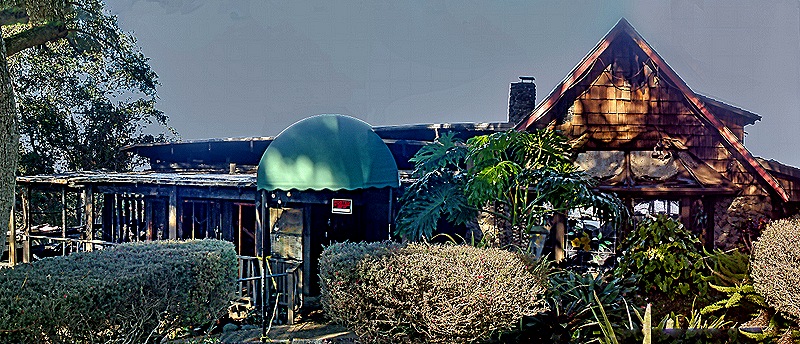
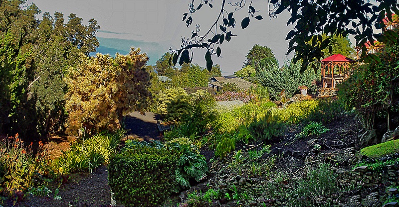
We drove across Maui in a bus driven by our engaging and talkative guide Wendell, a native Hawaiian. We passed farms, open terrain and the airport on our way; we have been on many longer drives during excursions, but this one was not short. As we drove up the mountain we made two stops, in part to give us a chance to acclimatize gradually to the higher elevations. Our first stop was at the Kula Lodge, near the town of Kula. Kula actually isn’t a town but a “census designated place,” because Hawaii has no incorporated towns or cities, just counties. Kula was the birthplace and childhood home of Dr. Sun Yat Sen, who led the revolution that overturned the Chinese Empire. Kula had a rather nasty fire in 2023 at the same time as the Lahaina fire, which destroyed more than 24 houses in this small town but left this Lodge untouched. However in August of 2025, about 5 months before our visit, their restaurant was destroyed by a fire. So when we visited they were selling food from a food truck behind their artisan market. There were some nice flowers here, notably poinsettias blooming on tall bushes. There was also a beautiful view down the mountain from the back of the market building.


Our next stop on the way up was the Ranger station for Haleakala National Park. It was full of maps, posters and other exhibits about the park, it had a great view across from the back and a lot of unusual plants that, we understand, only grow on this island. Notable among them is the Haleakala Silversword which at one time covered the volcano’s top to the extent that it looked like a snow cap. This plant only grows here and only from 7.000 to 10,000 feet (there is another variety growing on the big island). It naturally lives between 15 and 90 years and blooms once just before its death, sending up a tall stalk with many flowers. It has been listed as endangered since the 1990’s as a result of damage from visitors and grazing animals earlier in the 20th century. While they are protected today from human and animal damage, climate change is apparently taking a toll.


From here our path to the top was along many fairly sharp switchbacks with views of the vast expanse below. The mountain top above the clouds in the distance may be Mauna Kahalawai, Maui’s other volcano: older, shorter and more eroded than Haleakala.

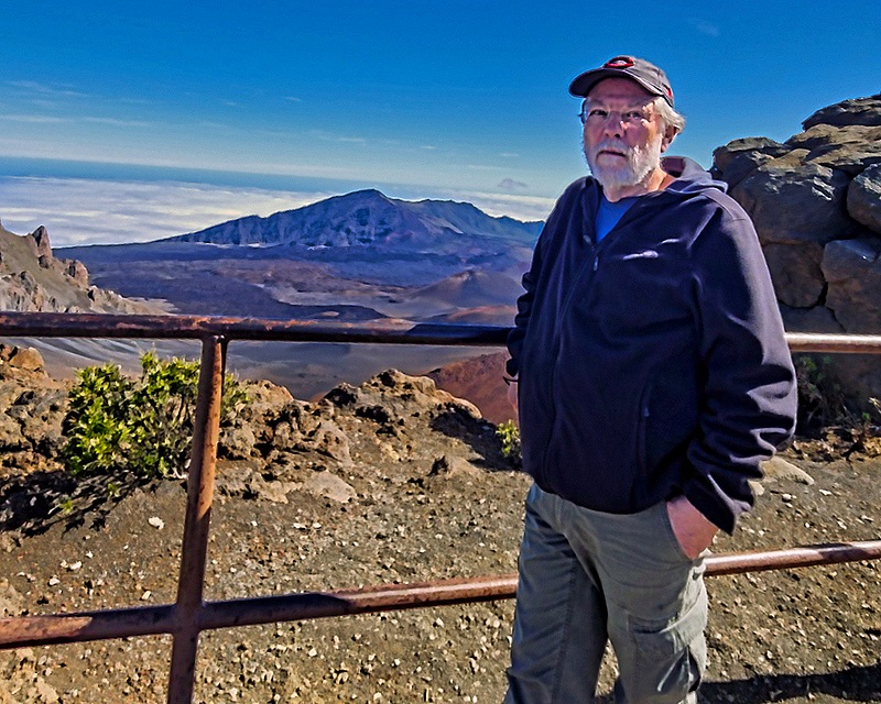
Haleakalā is more than 10,000 feet tall and its slopes make up more than three fourths of the island of Maui. The volcan’s name means “house of the sun” and the Hawaiians believed that its peak was the home of the grandmother of Maui, a demigod after whom the island is named. It has erupted 10 times over the last 1,000 years, the last eruption being estimated to have occurred during the 16th century. The volcano is dormant, not extinct, so another eruption in the future is possible. We parked in a small lot adjacent to a visitor center with its explanatory exhibits. Then we walked out to the observation area, happily protected by a metal fence. It was quite a view.


This huge crater is more than 11 miles across, more than 3 miles wide, and more than 2,500 feet deep. As we understand it, this is not the usual crater formed by volcanic activity but a depression mostly formed by the confluence of two rift zones (areas where the ground is pulled apart, presumably by tremors) along with erosion. There are, however, some smaller volcanic cones inside the crater.
To the right of the observation point is a very rocky higher summit with a stairway path leading around to the top. The summit was only about a fifth of a mile but it was a very steep path with very large steps (especially for folks with shorter legs). Mary stayed near the observation point and listened to a Ranger talk about the materials making up the caldera while Rick climbed the stairway. I (Rick) intended to climb until I was tired and then come back, but I kept passing families with children descending from the top and it seemed like it couldn’t be too far to the top. So I kept going and did reach the summit, which had its own viewing point.


As you can see from the pictures above, the view from the summit was pretty similar to the one from the lower observation point, except for the better angle. Perched on a neighboring hill that could be seen clearly from the steps while descending the summit was the Haleakalā Observatory. This location lies above the atmosphere’s inversion layer, giving particularly clear views of the sky. A number of astronomical projects share this space, including one that has discovered more than 4,700 space objects from asteroids to stars, and one operated by NASA that tracks the artificial objects orbiting the Earth. It is not open to the public.


By the time I got back down to the visitor center it was time to leave. We drove back down the way we came, with nice views of the seacoast and the settlements at the bottom of the mountain. We spent the rest of the afternoon on the ship and in the evening we said goodbye to Hawaii and sailed away for five days at sea.


Kona, Hawaii 2026
We spent January 12 in Kona. We had seen most of the landmarks in this small town on our first visit here in 2024, which you can see here:
https://baderjournal.com/2024/04/02/kona-hawaii-2024/
So this time we signed up for an excursion that would take us along the coast to the south. This was a tender port so we had to be ready to leave by 7:30, which necessitated a hurried early breakfast. We boarded our tour bus near the tender port where we met our driver & guide, Gabriel, who was very knowledgeable about the history and ecology of the area and shared a lot of that with us.
We didn’t stop or really see much of it, but at a point pretty far down the coast Gabriel told us we were passing Kealakekua Bay where Captain Cook was killed (and possibly eaten) during his third voyage on February 14, 1779. This was Cook’s second visit in a few weeks; the first had been very friendly but the second deteriorated rapidly (possibly because his return disabused the Hawaiians of their impression that he was one of their gods). Cook’s visit might have been the first by a European and he named the archipelago the Sandwich Islands after Lord Sandwich, who was one of the sponsors of his voyage. Here are a couple of distant photos of that bay (we think) as we drove past on the road.


Our first stop was at the Royal Kona Coffee Center. Kona coffee is well known as a premium brew and it is very expensive. Widely marketed in Hawaii, it is only grown in this area, mostly at farms on the slopes of volcanoes. The Coffee Center had an area where various brands of Kona coffee could be tasted free of charge. We tried some and it was good, but really it tasted like . . . coffee. We didn’t buy any. In addition to coffee, the Coffee center sold a variety of souvenir items and was a nice place to visit. It was situated on a high hill with a beautiful view overlooking a lush woods toward the sea.


We walked down a long path on the hillside behind the Coffee Center to visit a lava tube. Lava tubes can be formed in several ways, but are basically long tunnels (one in Hawaii extends for some 40 miles) through which lava can flow for much greater distances than it can over land. The one we visited was not very long but quite interesting to walk through. It was lighted inside by electric ground lights, having a pretty dramatic effect on the lava patterns of the walls and ceiling. We had planned to visit one of these during our visit to Hilo in 2024 but it didn’t work out, so we were happy to have a second chance here.


We saw many beautiful flowers in this part of Hawaii.


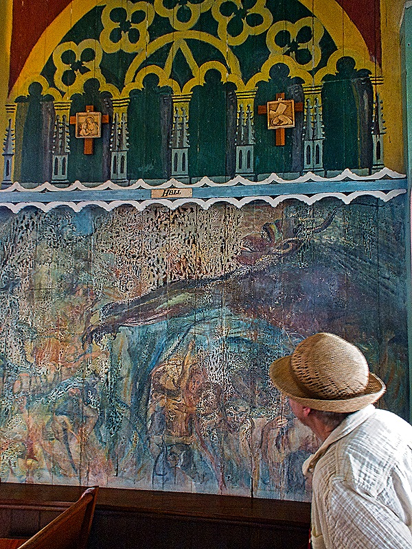
Next we visited St Benedict’s Catholic church in Honaunau. It was constructed beginning in 1899 under the direction of Father John Velghe, a Belgian missionary who led the church until he returned to Belgium in 1904. It is called “The Painted Church” because Father Velghe, with no artistic training, personally painted the entire inside of the church, using house paint on wood, between 1902 and 1904. The side walls have paintings of bible scenes, which served as teaching aids for a congregation that was largely illiterate. The wall behind the altar is painted to look like the inside of a European gothic cathedral. The support pillars are painted to resemble red marble with white paper spiraling up them containing religious sayings in the Hawaiian language, with palm fronds appearing to grow from them on the ceiling above. There are other “painted churches” in Hawaii, but this was the original. (Included below are three paintings depicting Cain & Abel studying Eve’s countenance, the temptation of Jesus (with the devil being cast out), and Mary (not the biblical one) looking at a depiction of Hell.)


Through a window of the church we could see the cemetery; the view out the front door was of the ocean.


Outside were extensive and colorful gardens, highlighted by what looked like a couple of small fir trees decorated with Christmas ornaments.


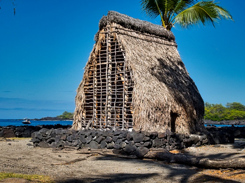
We continued on to Puʻuhonua o Hōnaunau National Historical Park. This was a “Place of Refuge” until the early 19th century, where individuals who had violated a sacred “kapu” (also known as taboo) could seek ritual cleansing and rehabilitation that would remove the applicable punishment of death. But to do so they would have to make it to the Hale o Keawe heiau (temple) here before being killed by pursuers seeking to enforce the kapu. This is a remote spot and reaching it while on the run was quite a challenge. The heiau was built in the 17th century.
But this was more than a Place of Refuge. There was a fishing village and artisan community. Kona’s last kings lived here on the other side of a wall from the heiau and their remains were buried here, as were other important nobles called ali’i. In 1829 the royal remains were moved to a hidden vault in the cliffs overlooking nearby Kealakekua Bay and the heiau was destroyed.
The national park was established in 1955 and in 1960 the heiau was rebuilt on its original site, based presumably upon archeological discoveries and 19th century drawings. Beside the rebuilt heiau are a number of fierce looking wooden carvings representing Hawaiian deities. The lava rock wall that separated the heiau from the royal residence is still there and still imposing (though it has probably been restored to some extent).


Standing on the rock sea wall in front of the heiau were a couple of carved guardians and there was another further down looking out over the water. Walking on the rocks by the water was kapu!


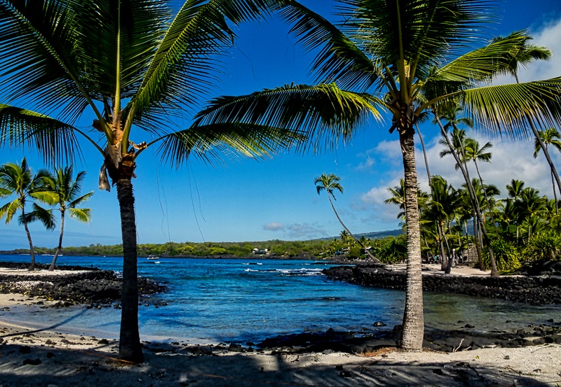
There were a few more reconstructed buildings on the site and also what once were fishing holes surrounded by sand. Across the water was a lava shelf for snorkeling (which is mostly forbidden inside the Park). As we returned to the bus we passed a very picturesque inlet, with which we will end our visit to the Park.


When we left the bus on the tender dock in Kona there was still plenty of time before all aboard. We met up with our friends Donna and Karen and went looking for the Quilt Museum that we had missed last time we were here, located by a quilt shop we had visited. When we got there the quilt shop and museum were gone. Some quick internet research enabled us to find the shop a few blocks away. They had lost their lease and had to move, but they had no space for the museum so we missed that again. It sure went fast, just two years since we were here. Maybe it will reappear before the next time we visit Kona, if that happens (you never know). The four of us had lunch at Quinn’s Almost By The Sea, where we ate last time we were here, and Karen’s brother Roger joined us for another good meal. We tendered back to the ship to rest up for a mountain trip tomorrow.
Honolulu, Hawaii (Day 2) 2026
For January 11, our second day in Honolulu, we scheduled a private tour to Pearl Harbor. Pearl Harbor is a difficult place to visit on your own because it involves three different sites, tickets that usually must be arranged in advance, and there’s a lot to see in one day. This might be the way to go if you will be here for several days, but we had only one day so if anything didn’t work out as planned there would be no opportunity for a do-over. The tour we took was not cheap but it was really very good and enabled us to avoid all the logistical uncertainties.
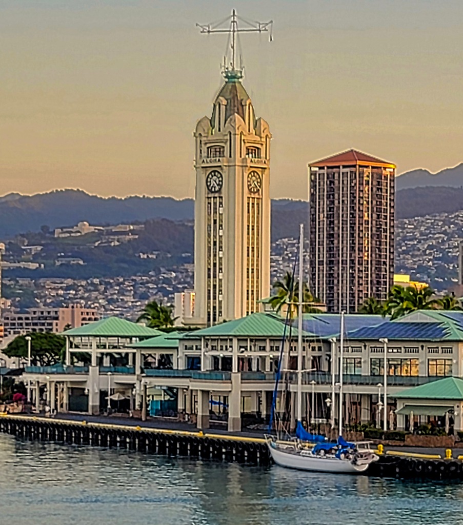
We met our van in front of a park next to the cruise terminal. At the front of the park was a sculpture of a hula dancer with real flower leis hanging from her arms. At the back of the park was the Aloha Tower, 184 feet (10 stories) tall with another 40 feet of flagstaff. Built in 1926 it was the tallest building in Hawaii for 40 years. The top section has large clock faces on each side.


Our guide, Billy Crowe, was driving the van, which already had two other couples who were not from the cruise. Our first stop was the airport, where we picked up another couple who had just flown in for the day to do this tour (we dropped them back at the airport later on our way back to the pier). Billy was a retired park ranger who had spent many years at this park, so he was very knowledgeable and we learned quite a lot from him. We continued to Ford Island in the center of Pearl Harbor.
The national park includes a memorial to the victims who were killed here on the first day of the war and a few hundred yards away the ship on which the Japanese surrender documents were signed less than five years later to end the war. We visited them backwards from the war chronology, starting with the USS Missouri. As we walked to the entrance to the ship we passed a memorial to the men who died during the Japanese attack on the USS Oklahoma. The Oklahoma was a battleship commissioned in 1916 that had served during World War I. During the attack on December 7 the Oklahoma was docked along with a number of other battleships in an area called “Battleship Row.” It was hit by multiple torpedoes and capsized, trapping most of the crew inside. A few survived by jumping into oil covered water or climbing along a rope connecting it to another battleship, but 429 sailors and marines were killed. It was one of the few Pearl Harbor ships damaged so badly it couldn’t be salvaged. The memorial was erected on December 7, 2007.
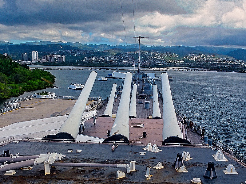
 We walked on to the USS Missouri, passing on the way a statue of Admiral Chester Nimitz, who was Commander in Chief of the US Pacific Fleet. There is a large street in downtown Honolulu named for him. A whole row of American flags lined the walkway to the ship and in front of the ship were displayed the flags of all the US states in order of admission (we think).


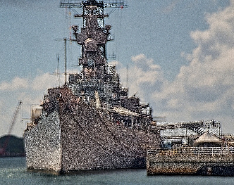
The USS Missouri is here representing the end of World War II because the Japanese documents of surrender were signed on the quarterdeck of this ship on the morning of August 31, 1945. The 23 minute signing ceremony was broadcast on radio throughout the world. The ship was anchored in Tokyo Bay near where Admiral Perry had anchored in 1853 on his mission to open Japan to international trade, and the flag flown by Admiral Perry at that time was displayed on the Missouri on the day of the signing. There is a round bronze plaque on the deck at the location where the signing desk stood.


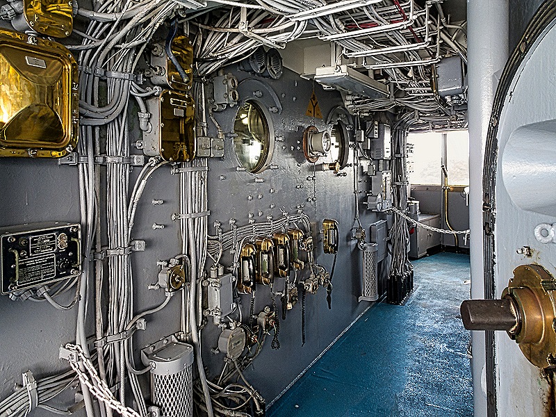
The USS Missouri was the last battleship commissioned by the United States, launched in January, 1944. Having served in World War II, Korea and the Gulf War. the ship was decommissioned and moved to Pearl Harbor in the 1990’s and was opened to the public as a museum in 1999. It was updated several times over its lifetime and had previously been decommissioned between 1955 and 1984. We had enough time there to explore the ship, but Billy was unable to guide us here (or in the other venues) because private guides are not permitted to lead tours in Pearl Harbor. There were park rangers in some places to explain the facilities, however, and they were rather good. One interesting story, for example, was about a kamikaze that crashed on the side of the ship in April of 1945, which caused little damage to the ship but destroyed the plane. The pilot’s body was recovered and the next day the ship held a formal burial at sea, with the body wrapped in a Japanese flag sewn overnight by several of the crew.


Leaving the Missouri we reboarded the van and drove to the large visitors’ center that provides access to the two other vessels we were to visit. It is operated by the National Park Service in cooperation with the Navy and more than a million people visit every year. Again Billy could not accompany us, but he gave us detailed instructions about how to negotiate the facility and make it to the boat that would take us to the USS Arizona Memorial. There was a fairly short film to watch about the December 7 attack and then we had to find the boat dock (not as easy as we had hoped). You need to have a ticket reserved in advance since only a few are held back for those in the stand by line who arrived without one. In addition to the movie theater the visitor center complex has souvenir stores and some exhibits, but we didn’t have time for that. We boarded the boat and headed for the Memorial. The Memorial is a simply designed long white building situated over the central portion of the USS Arizona sitting on the bottom under about 40 feet of water. It is very striking, particularly on a day with dark clouds as when we visited. Our boat moored at one end of the memorial where there was a metal walkway leading us to the entrance.


The USS Arizona was a battleship commissioned in 1916. It was part of the Pacific fleet before the war when President Roosevelt ordered it to relocate to Pearl Harbor as a deterrent to the Japanese. The Arizona was scheduled to leave Hawaii in November of 1941 for an overhaul, but a collision with the USS Oklahoma on October 22 damaged its bow which led to its putting in to Pearl Harbor for repairs instead. The surprise attack by Japanese planes from several aircraft carriers began at 8:00 AM on December 7 and about10 minutes later the Arizona was sinking toward the bottom. It was struck by four armor piercing bombs, the last of which penetrated the forward deck and about seven seconds later the forward munition magazines exploded, destroying much of the interior of the forward part of the ship and bringing down the conning tower and the forward turrets. The fires burned for 2 days as the ship sat on the bottom with only its top parts above the water. 1,177 of the 1,512 crew on board were killed, about half of all the American lives lost during the attack.
The memorial opened in May, 1962. It is 185 feet long, 36 feet wide and 21 feet tall. According to the architect Alfred Preis (who had been a detainee when the war started because of his Austrian birth), the sagging center and strong tall ends were intended to express “initial defeat and ultimate victory. . . .” The atmosphere here is very quiet as visitors contemplate what it represents, each with their own views and memories. The main room has seven windows along each wall and an opening in the floor where you can look down at the ship and, for those who want to, drop flowers in the water. From the windows on one side you can see the USS Missouri and several parts of the Arizona that remain above water, including the barbette (or base) for one of the triple gun turrets, the base of the ship’s funnel (we think), and several mooring bitts along one edge of the ship. The item we think is the base of the funnel has a metal ladder attached to the inside of its wall. The amount you can see clearly depends on the tide.

 for gun turret (far) and probably the funnel with interior ladder (closer)")


At the end farthest from the entrance to the Memorial is a smaller and darker room called the shrine. Its largest wall is covered in marble bearing the names of all the men killed on the Arizona on December 7. There is a small slab of marble on the left with the names of some 30 crew who survived the sinking. All this is behind velvet ropes and sunlight enters from the side through windows giving a restrained, almost church-like glow. The marble exhibits have been replaced twice (so far) because of deterioration of the marble. Survivors of the Arizona sinking have been entitled to have their remains deposited inside the ship by divers if they want to rejoin their long ago shipmates. Our guide Billy was one of those divers when he was working here. The last survivor, 102 year old Lou Conter, died in April, 2024, just a year and a half before our visit here.

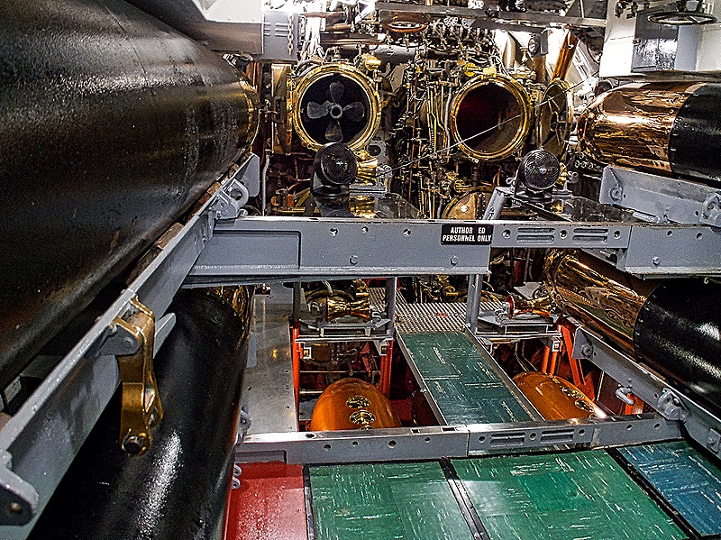
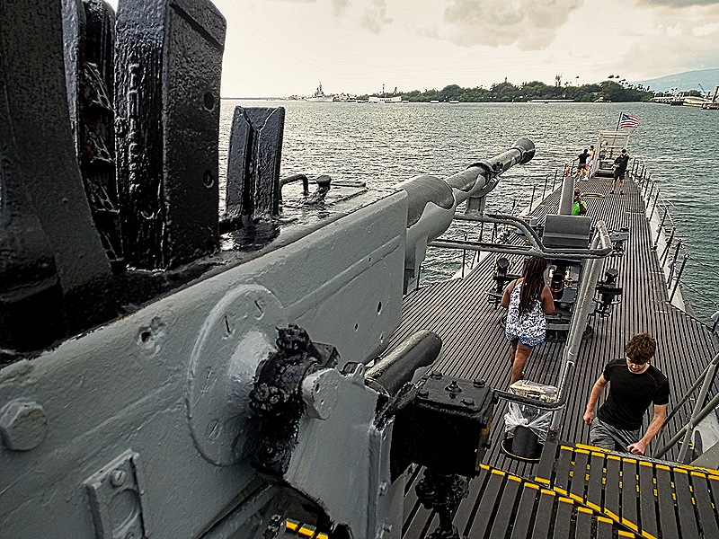
We returned to the visitor center complex and had a quick lunch at a food court near our last destination, the Bowfin submarine. The Bowfin was launched on December 7, 1942, the first anniversary of the Pearl Harbor surprise attack. It conducted nine patrols over the next two years, successfully sinking or maiming a number of Japanese ships, and also served during the Korean war. It was first opened to the public in April, 1981, and a submarine museum was opened nearby in 1988. We boarded the submarine on a ramp attached to its bow then went down and walked through its length, from the forward torpedo room through sleeping facilities (3 layers of bunks) and operations areas, all very crowded. We came up on deck at the aft near the US flag and walked forward past some sort of cannon and an anti-aircraft gun mounted in front of the tower.


 & tower")

We walked back to the van and left Pearl Harbor. We stopped again at the airport to drop off the couple who had flown in for the tour, then back to the cruise terminal. We had a nice dinner and then to bed, since we had another excursion the next morning on a different island.
Honolulu, Hawaii 2026 Day 1
After five days at sea we awoke as Zaandam pulled into the dock in Honolulu on the morning of January 10. Our dock was very close to the iconic Aloha Tower, built as a lighthouse in 1926, that has been welcoming visitors to Honolulu ever since.


We first visited here on a one day stop in 2024, which isn’t nearly long enough to fully explore this city. The blog episode for that visit, which includes background information we won’t repeat here, is at this link: https://baderjournal.com/2024/04/15/honolulu-hawaii-2024/. This time around we had a more leisurely two days here.
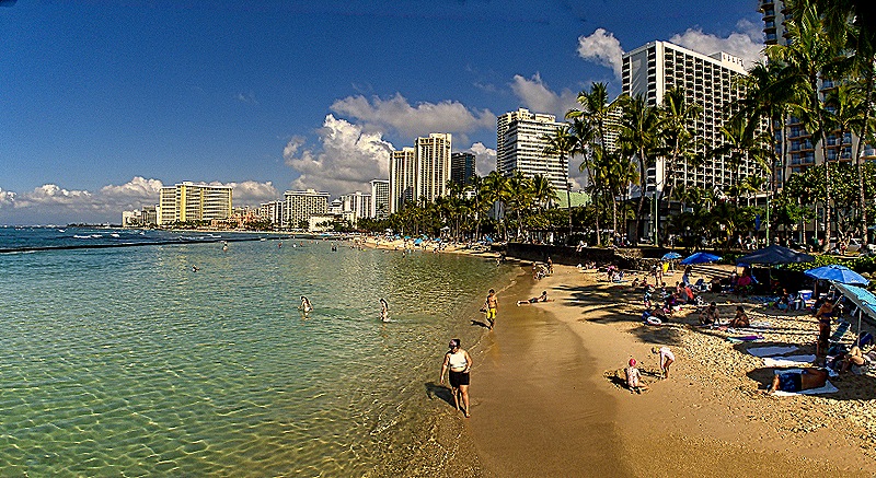
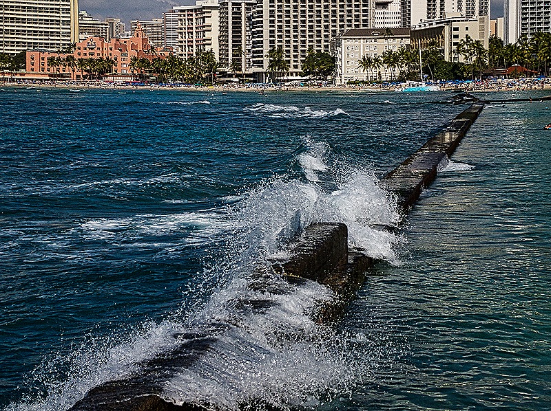
We decided to spend our first day in the Waikiki area. We found a nearby bus stop and rode down Ala Moana Blvd to Waikiki. We walked along the streets lined with restaurants, stores and tall hotels, then turned right and headed toward the beach. The beach is long and not too wide in front of the long line of resort hotels. It looked peaceful and uncrowded on this morning in January. There were several sea walls, some protecting the swimming area from the ocean with waves breaking on the wall instead of the beach and some dividing different sections of the beach. We walked out on one wall toward the ocean to get a better view.


Waikiki means “place of spouting waters,” so named because it originally was a marshy area of wetlands fed by streams from the mountains. It had been inhabited for centuries by farmers and fishermen when it briefly became the first capital of the Kingdom of Hawaii In 1795 and 1796. After the capital moved to Kona this continued as a vacation retreat for Hawaiian royalty but for a long time it was accessible only from the sea as there were no roads. In the 1890’s the monarchy was overthrown, mainly by American business men (some the descendants of missionaries) looking to improve their commercial prospects and it was in that same period that a few hotels first appeared in the area. Construction of a canal in the 1920’s led to elimination of the wetlands. The dynamic growth of air travel after World War II greatly increased the tourist trade so that by the middle 1950’s Waikiki was inundated with the huge and luxurious beach hotels that dominate its skyline to this day.
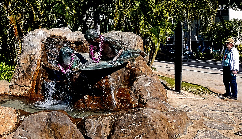
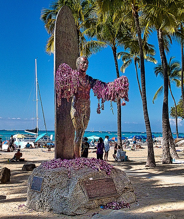
The beach area has several interesting sculptures. One that we passed is called “Makua and Kila.” Erected in 2001 and inspired by a short story, it shows a boy on a surfboard with a seal swimming along side. Another is a statue of Duke Kahanamoku, a Hawaiian celebrity considered the father of modern surfing. Born in 1890, Duke (his given name rather than a nickname) grew up in the Waikiki area. He won five Olympic medals in swimming between 1912 and 1924 and was well known as a world ambassador for surfing, which he was instrumental in popularizing in California and Australia. He appeared in small roles in a number of Hollywood movies and was the elected sheriff of Honolulu from 1935 to 1961. His statue on the beach dates to 1990; nine feet tall it shows him standing in front of his surfboard with arms outstretched. Flower leis are often seen on his arms, as they were when we were there.


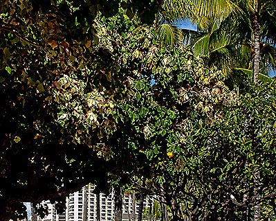
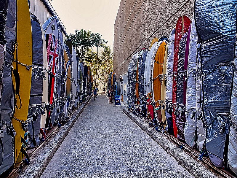
We stopped in a pavilion where a group of locals were performing music and, this being Hawaii, even in January we saw many beautiful flowers on trees, bushes and flower stalks (imagine what this would be like in May). We mentioned above that modern surfing really got its start here and we saw a number of surfers on our walk. It appears that certain stretches of the beach are set aside for surfers. There were racks of colorful surfboards on the beach and on what seem to be alleys leading into town.


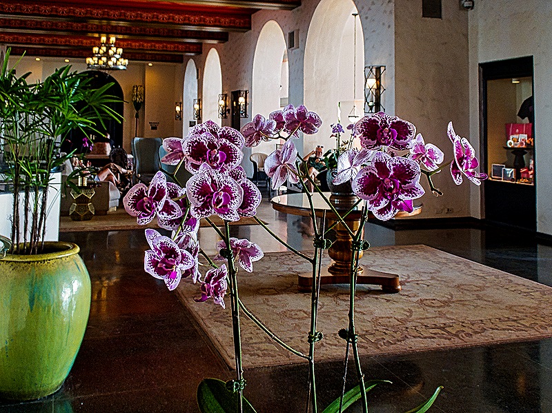
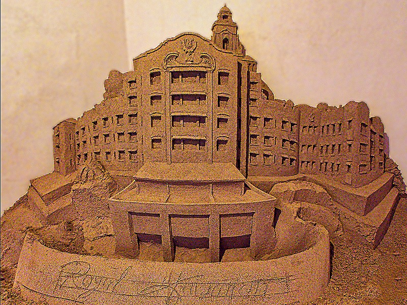
The most distinctive hotel on the beach is one of the shortest, the hot pink Royal Hawaiian Hotel. When opened in 1927 it was one of only 2 or 3 in this area and must have had a commanding view of the ocean, the beach and Diamond Head, the large volcano crater at the end of Waikiki. We could still see Diamond Head, of course, from the beach in front of this hotel. It is an expensive luxury hotel, beautiful inside with lots of flowers and plants and specialty shops and (at least when we visited) an impressive sand sculpture of the hotel in the lobby.


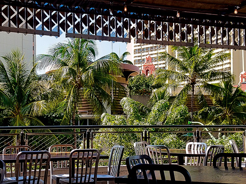
 We had hoped to find a lunch spot in the hotel, but we didn’t see one. So we walked back inland to a large commercial street nearby where we stopped for pizza and a beer at the Maui Brewing Company, a pleasant open air veranda above a stairway to the second floor. It had a nice breeze, was not crowded and had a view over the street in the direction of the beach. The pizzas and beer were unusual and quite tasty. Mary left with one of their tee shirts.
")


We walked down a few blocks to the zoo, where the bus turns around to go back toward the port. We asked the bus driver waiting there whether his route would take us past the Honolulu Art Museum we wanted to visit. He said he would pass nearby, but pointed out another bus across the street that would take us right to the museum. We took that bus right to the front door of the museum and the driver called out the stop when we got there. Two unusually helpful bus drivers, in our experience. Founded in 1922, the museum has a large and eclectic collection, ranging from European masters to the nation’s biggest collection of Asian and Pan-Pacific art, and everything in between. Of course, only a portion of that is on view at any one time and this draws your attention to individual artworks rather than roomfuls of works by each artist. It is housed in a lovely set of small buildings with courtyards, flowering plants and a cafe. We enjoyed our time here, but it did not seem to be on the same level with world class museums like the Louvre or the National Gallery in Washington, and we thought the $25 per person admission was excessive for what was presented. We also found it irritating that only people visiting from outside Hawaii had to pay this much, since Hawaiian residents were given a large discount.


We decided to walk back to the ship from here. After a long walk we stopped at the Hawaii State Library, a pillared building in the downtown area that opened in 1913. With a collection of more than half a million items this is the flagship branch of the Hawaii State Public Library System, the only statewide library system in the US. The library was undergoing renovations and appeared to be closed when we approached so we were happy to find that walking around the building to the front revealed open doors that allowed us to visit the rather striking interior. We saw several colorful birds near the library as well.

 g
g


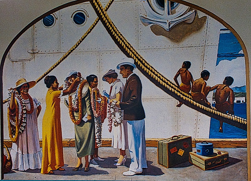
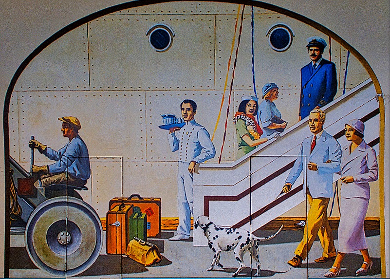
When we reached the port we walked through the Pier 11 passenger terminal to reach the ship. The terminal is a large room resembling an airplane hangar with security checks at the entrance. Two of the walls are covered in murals depicting Hawaiian scenes mostly at the pier that look like they were painted in the 1920’s or 30’s (we have been unable to find any information on when they were actually painted). In our opinion they are interesting enough to warrant a visit even if you aren’t boarding a ship there. And so ends day 1 in Honolulu.


")
Voyage to Australia & New Zealand 2026
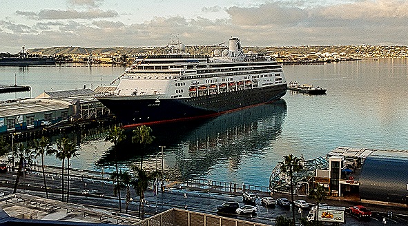
On January 4 we boarded the Holland America ship Zaandam in San Diego for a three month voyage to Australia, New Zealand and many Pacific islands (including Hawaii). Our previous sailings from the West Coast had been limited to Alaska cruises in 2017 and 2025 and for both of those we drove across country to board the ships. This time we flew across the continent and the airline experience was very different (and more challenging) than our last domestic flight several decades ago.
We arrived in San Diego on January 3 after a largely uneventful flight. Our hotel was right across the street from the dock and close enough to the airport that we could see it from our balcony across the bay. By morning the Zaandam was moored at the dock. We watched while the crew uncovered the logo for the Grand Australia and New Zealand Voyage on the front of the ship under the bridge. We had breakfast at the hotel with our old friend Cecile who lives in San Diego, then walked over and embarked on the ship around noon.


Our itinerary on this voyage included Hawaii, an almost complete circumnavigation of Australia, a number of ports in New Zealand and a whole lot of islands with a return to San Diego in early April. Here is a map of the full itinerary followed by a listing of all the scheduled ports (with only a few minor inaccuracies).

|
DATE
|
DAY
|
PORT
|
ARRIVE
|
DEPART
|
|
Jan 4
|
Sunday
|
San Diego, California
|
Embark
|
4:00 PM
|
|
Jan 10
|
Saturday
|
Honolulu, Oahu, Hawaii*
|
7:00 AM
|
—
|
|
Jan 11
|
Sunday
|
Honolulu, Oahu, Hawaii
|
—
|
9:00 PM
|
|
Jan 12
|
Monday
|
Kona, Hawaii
|
8:00 AM
|
6:00 PM
|
|
Jan 13
|
Tuesday
|
Kahului, Maui, Hawaii
|
8:00 AM
|
6:00 PM
|
|
Jan 19
|
Monday
|
Pago Pago, Tutuila, American Samoa
|
8:00 AM
|
5:00 PM
|
|
Jan 20
|
Tuesday
|
Crossing International Dateline
|
—
|
—
|
|
Jan 21
|
Wednesday
|
Apia, Upolo, Samoa
|
8:00 AM
|
5:00 PM
|
|
Jan 23
|
Friday
|
Savusavu, Vanua Levi, Fiji
|
8:00 AM
|
5:00 PM
|
|
Jan 24
|
Saturday
|
Suva, Viti Levu, Fiji Islands
|
8:00 AM
|
6:00 PM
|
|
Jan 25
|
Sunday
|
Lautoka, Viti Levu, Fiji
|
8:00 AM
|
5:00 PM
|
|
Jan 27
|
Tuesday
|
Easo, Lifou, New Caledonia
|
8:00 AM
|
5:00 PM
|
|
Jan 28
|
Wednesday
|
Noumea, New Caledonia
|
8:00 AM
|
5:00 PM
|
|
Jan 30
|
Friday
|
Port Vila, Vanuatu
|
8:00 AM
|
5:00 PM
|
|
Feb 1
|
Sunday
|
Honiara, Guadalcanal, Solomon Island
|
8:00 AM
|
5:00 PM
|
|
Feb 3
|
Tuesday
|
Rabaul, Papua New Guinea
|
8:00 AM
|
5:00 PM
|
|
Feb 5
|
Thursday
|
Alotau, Papua New Guinea
|
8:00 AM
|
5:00 PM
|
|
Feb 6
|
Friday
|
Kiriwina Island, Papua New Guinea
|
8:00 AM
|
5:00 PM
|
|
Feb 8
|
Saturday
|
Cairns, Australia*
|
8:00 AM
|
5:00 PM
|
|
Feb 9
|
Monday
|
Cairns, Australia
|
8:00 AM
|
5:00 PM
|
|
Feb 10
|
Tuesday
|
Scenic Cruising – The Great Barrier Reef Experience
|
—
|
—
|
|
Feb 11
|
Wednesday
|
Scenic Cruising – The Great Barrier Reef Experience
|
—
|
—
|
|
Feb 12
|
Thursday
|
Scenic Cruising Torres Strait
|
—
|
—
|
|
Feb 14
|
Saturday
|
Darwin, Australia
|
8:00 AM
|
5:00 PM
|
|
Feb 16
|
Monday
|
Broome, Australia
|
8:00 AM
|
5:00 PM
|
|
Feb 18
|
Wednesday
|
Exmouth, Australia
|
8:00 AM
|
5:00 PM
|
|
Feb 20
|
Friday
|
Fremantle (Perth), Australia*
|
8:00 AM
|
—
|
|
Feb 21
|
Saturday
|
Fremantle (Perth), Australia
|
—
|
5:00 PM
|
|
Feb 23
|
Monday
|
Albany, Australia
|
8:00 AM
|
5:00 PM
|
|
Feb 26
|
Thursday
|
Adelaide, Australia
|
8:00 AM
|
11:00 PM
|
|
Feb 27
|
Friday
|
Penneshaw, Kangaroo Island, Australia
|
8:00 AM
|
6:00 PM
|
|
Mar 1
|
Sunday
|
Melbourne, Australia
|
8:00 AM
|
5:00 PM
|
|
Mar 3
|
Tuesday
|
Hobart, Tasmania, Australia
|
8:00 AM
|
—
|
|
Mar 4
|
Wednesday
|
Port Arthur, Tasmania, Australia
|
9:00 AM
|
4:00 AM
|
|
Mar 6
|
Friday
|
Sydney, Australia*
|
8:00 AM
|
—
|
|
Mar 7
|
Saturday
|
Sydney, Australia
|
—
|
5:00 PM
|
|
Mar 10
|
Tuesday
|
Milford Sound, New Zealand
|
7:00 AM
|
8:00 AM
|
|
Cruising Fiordland National Park
|
—
|
—
|
||
|
Mar 11
|
Wednesday
|
Port Chalmers (Dunedin), New Zealand
|
7:00 AM
|
6:00 PM
|
|
Mar 12
|
Thursday
|
Timaru, New Zealand
|
7:00 AM
|
3:00 PM
|
|
Mar 13
|
Friday
|
Wellington, New Zealand
|
8:00 AM
|
5:00 PM
|
|
Mar 15
|
Sunday
|
Tauranga (Rotorua), New Zealand
|
7:00 AM
|
7:00 PM
|
|
Mar 16
|
Monday
|
Auckland, New Zealand*
|
8:00 AM
|
—
|
|
Mar 17
|
Tuesday
|
Auckland, New Zealand
|
—
|
5:00 PM
|
|
Mar 18
|
Wednesday
|
Waitangi (Bay of Islands), New Zealand
|
8:00 AM
|
5:00 PM
|
|
Mar 21
|
Saturday
|
Nuku’alofa, Tonga
|
8:00 AM
|
5:00 PM
|
|
Mar 22
|
Sunday
|
Crossing International Dateline
|
—
|
—
|
|
Mar 24
|
Tuesday
|
Papeete, Tahiti, French Polynesia*
|
8:00 AM
|
—
|
|
Mar 25
|
Wednesday
|
Papeete, Tahiti, French Polynesia
|
—
|
4:00 AM
|
|
Bahia d’Opunoha, Moorea, French Polynesia
|
9:00 AM
|
10:00 PM
|
||
|
Mar 26
|
Thursday
|
Raiatea, Society Islands, French Polynesia
|
8:00 AM
|
11:00 PM
|
|
Mar 27
|
Friday
|
Bora Bora, French Polynesia
|
8:00 AM
|
11:00 PM
|
|
Mar 29
|
Sunday
|
Fakarava, Tuamotu, French Polynesia
|
8:00 AM
|
5:00 PM
|
|
Mar 31
|
Tuesday
|
Taiohae, Nuku Hiva, French Polynesia
|
8:00 AM
|
5:00 PM
|
|
Apr 7
|
Tuesday
|
San Diego, California
|
7:00 AM
|
Disembark
|
|
*overnight stay
|
We spent the day unpacking and settling in. We discovered at dinner that we had been assigned (without requesting it) to table 65 in the Main Dining Room, the same table we had occupied on our first two world cruises on the old Amsterdam, an almost identical sister ship of Zaandam. And in another welcome coincidence two other people assigned to our table, Roger and Karen, had shared our dinner table on the Alaska Solstice cruise the previous summer. When night fell the brightly lit San Diego waterfront looked like it was dressed up for Christmas as we sailed away.for five days at sea before reaching our first port.


