Quepos, Costa Rica (2024)
Quepos is a small town of about 20,000 on the Pacific Coast of Costa Rica. We woke up to a beautiful sunrise on the morning of January 26, anchored near the town’s shore.


The town is named after the area’s original inhabitants, the Quepo people, who were subjugated by Spanish conquistadors who settled here in 1563. Today it is a center for sport fishing, especially sailfish, marlin and tuna, and it hosts fishing competitions. There is a yacht harbor with a 200 boat capacity that opened about 10 years ago. The harbor was mostly filled with sport fishing boats. We tendered ashore to the yacht harbor.


There didn’t seem to be too much to see or do in this town (apart from fishing), so we signed up for an excursion to a rain forest reserve about an hour’s drive up the coast. In the 1930’s banana plantations sustained the economy here but they were wiped out in the 1950’s by banana blight. African palms were planted in their stead and today the area produces substantial amounts of palm oil. On our way to the reserve we passed a number of palm plantations with their trees planted in neat rows, not the usual way palms appear. We also passed some rural villages and buildings scattered throughout the area, although we have no idea how typical they are.


We departed the bus and walked to boats on the Tarcoles River from which we would look for animals and birds that live here in abundance. Unfortunately it is impossible to ignore the large volume of trash spread out on the shore and in trees and bushes, which is rather demoralizing. Sometimes we took a picture of something brightly colored and upon closer look at the picture discovered that it was a piece of trash rather than a bird. We were told that littering is illegal here but that was obviously not being enforced. The walk to the boats, however, took us past many nice flowers among the trees and bushes.


One of the largest and most ubiquitous animals in this area is the American Crocodile. This river has the largest concentration of crocodiles in Central America. We saw several of them, mostly relaxing by the river’s edge. These crocodiles are sort of white, not the traditional green.


One crocodile was holding its mouth open, something they do sometimes not to scare anybody but to avoid overheating. We saw one couple, with a female by the river bank and the larger male mostly submerged nearby. Then there was a small, probably very young, crocodile jumping for food that someone in another boat was holding out. Not only is this dangerous for your hand, but we were told there is a law against it, although not effectively enforced.


Other animals we spotted (with help from the guide) were a Basilisk, known locally as a Jesus Christ Lizard because it can walk on water, and a White Faced Capuchin Monkey, an endangered species. Both were hard to pick out in our pictures, the lizard because it blended so well with the rock on which it sat and the monkey because it was small and hidden in shadow behind large leaves that made it almost invisible in the bright sunlight. Actually we didn’t see them at the time, but the guide did so we took pictures in the direction he indicated then searched for them in the pictures later.

![]()
There were quite a few species of birds, shown here in no particular order. We know the names of some, but will have to guess about others. First, a Yellow Crowned Night Heron and an Osprey.


A Roseate Spoonbill was hunting food in shallow water. A Green Kingfisher was perched on a dead tree branch. There was an Anhinga, called a snake bird for its disproportionately long neck and short legs. And graceful looking Little Blue Herons were there as well.


 . We saw a Bare Throated Tiger Heron sitting on a log, then spreading its wings like it was sunbathing. And we think we saw another hidden in the bushes. There were Great Egrets and Black Vultures (looking a little like English judges with gray rather than black wigs). And there may have been a Black Necked Stilt as well.


![]()


We saw Little Egrets and what we think is a White Ibis. There were a lot of what we think are cattle egrets perching in downed tree branches. How do you tell a Great Egret from a Little Egret? The Great has a yellow bill and black legs while the Little has the opposite (black bill and yellow legs).


")


After the river cruise we proceeded back to the main building and boarded a cable car (which they call a gondola) for a ride high in the treetops of the rain forest. Each gondola held 8 people but they distributed us to make sure the gondola was balanced. Rick was seated in the single seat in the back and Mary was in front of him, with the seat to her right empty. The gondolas were transported very high in the air on cables held up by very long metal poles.


This was advertised as a chance to see wildlife & birds who live or work in the treetops but we didn’t see any at all, apart from a few insects that thought we looked tasty. But being this high over the top of the rain forest gives you an entirely different perspective. Trees and plants display interesting patterns when seen from above that you would never see from the ground and are often quite beautiful. After all, the leaves on trees and plants are intended to extend toward the sun, which is the direction where we were situated.


From inside the gondola we had distant views over the trees below and views of trails and streams that looked very far down.


At the end of the cable run where we were turned around to head back was a small double waterfall coming down a cliff face. There was also a ladder against a tall wall which might be used for rescue if the equipment fails or to perform maintenance on the system.


Finally, we saw bromeliads (air plants) growing on bare tree branches and a number of flowers and colorful leaves high in the trees. There was also what looked like a very large nut, sort of like a coconut but we think it was something else.


After leaving the gondola we had a very good buffet lunch in the main building of the facility, visited the gift shop (picture for Cecile, who likes gift shops), and spotted an iguana in front of the building on the edge of the driveway. He would stand on the edge watching the people action, then leap down if someone came toward him and hide in a pipe next to the driveway. It looked like he might be living in there.


We motored back to the port along the same road we had travelled in the morning. Shortly before reaching the port Rick saw a pair of beautiful Scarlet Macaws fly past the bus window, but it happened so fast there was no time to take a photo. Near the gate to the port was a sculpture of what looked like a sailfish sans back fin. Then we tendered back to the ship past a Windstar four mast cruise ship anchored between our ship and the harbor. So ended our Quepos adventure.


Panama Canal (2024)
We entered the Panama Canal very early in the morning on January 24 (before we were even up). The canal would take us to the Pacific Ocean by the express route, saving weeks by avoiding going around South America as ships had to do before the canal opened about 110 years ago. The Panama Canal is a wonder of technology and is always exciting to cross even for travelers who have been here many more times than we have. But this would be our 5th time through the canal, so much of the newness has worn off by now (witness our sleeping until after we entered the first locks). You can see more pictures and read a good deal more about the canal in our prior blog posts from here:
https://baderjournal.com/2019/01/22/panama-canal-2019/
https://baderjournal.com/2018/05/06/panama-canal-3/
https://baderjournal.com/2016/02/04/panama-canal/
https://baderjournal.com/2012/01/11/panama-canal-2-2/
After we woke up we walked out onto our veranda to see what there was to see. Not much, it turned out. We could look toward the aft and see part of the new Atlantic Bridge (opened in 2019) spanning the entrance to the locks, whicht was not very far behind us. And there was a tug boat near us that was pushing the ship into position to enter the narrower channel to the first lock.


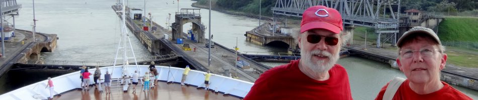
We hurriedly dressed and headed out to the bow area, where we could see where the ship was going. The initial set of locks on the Caribbean side are called Gatun and we were headed into the first level. The bow area is usually off limits to passengers but for the Canal crossing they keep it open. There was a tent set up there with a table for dispensing coffee and Panama Rolls (delicious sweet rolls with a kind of peachy filling) to those who came early, but all was gone by the time we arrived. The tent still served a purpose, however, as protection from the brutal sun. We were able to see the logo for the world cruise painted on the front of an upper deck, which was not previously visible from anywhere on the ship.


We also got our first look here at the “mules,” small vehicles running on railroad tracks along both sides of the locks. They attach to the ships with cables and are responsible for ensuring that the ship stays centered within its channel and does not touch the sides where there is very little leeway. They throw the cable to the ship for the crew to attach. We passed a target that the canal crew use to practice this throw.


We headed to the aft pool on deck 9, hoping there would still be Panama Rolls available there. They were out too, but looking back from the ship we saw the bridge over the canal entrance still visible and a Carnival ship entering the first lock behind us. Next to us was the Gatun control building. The doors of the locks are, we understand, the originals installed about 110 years ago. When a ship enters a lock the doors behind it close and water flows into the lock through pipes. As the water builds the ship floats up, until it reaches the same height as the next lock. At that point the doors in front of the ship open and it can sail into the next lock. The doors are massive and heavy. When closed people can walk across them.


We went down to the restaurant on deck 2 for breakfast. We were seated by a window and took some pictures but the windows were fogged and wet so they aren’t very good. A mule on top of the wall next to the ship was attached to the stern of the ship with cables and we watched the lock door open flush into a niche in the wall of the lock. We asked, with little remaining hope, whether they had any of the delicious Panama Rolls in the restaurant, but were told that they had not been given any. To our surprise and delight, our waiter returned about 10 minutes later with two of them on a plate. We have no idea who in the restaurant went to the trouble to find out where any were left (probably the Crow’s Nest) and then run up there to get them for us, but we were grateful. This is not atypical for HAL crew members.


We were back up on the aft pool deck as we came out of the third lock. The middle portion of the canal, between the Gatun and Pedro Miguel locks, is mostly a man made lake rather than what one pictures as a canal. Gatun Lake was made by damming off a river, and this lake now provides most of the water used to operate the locks and also supplies drinking water to some nearby communities. This has become a problem this year because of a historic drought in the region, leading to a reduction in ship traffic to save water. We saw one of the river dams from the ship as we sailed into the lake.
We also passed a turntable at the very end of the locks that is used by the mules to change direction. And you might have heard that about 8 years ago a second set of locks was opened in Panama to permit the much larger modern container and tanker ships that are too wide and long for the original locks to pass through. These new larger locks were on our left as we entered the lake and we saw the Ruby Princess cruise ship emerging from those locks into the lake.


The passage through the lake is fairly long and uneventful so we turned to other things. There were some islands and we noticed a series of buoys marking the safest path through the lake. As always, we had pilots on board to help direct the ship safely during the entire passage. In the past the canal authorities had required that one of their people narrate the canal passage through the ship’s speaker system but this time Kimberly, the cruise & travel director, was allowed to do it. This is a demanding job because it lasts so long and there is so much information to impart and Kimberly handled it well. Her background in television probably stood her in good stead here.


At the other end of the lake we came to the Culebra Cut, an almost 9 mile channel cut through the rock of the continental divide to connect the lake to the Pacific Ocean. Some 6,000 men worked there at any one time, working with dynamite and dodging landslides that could wipe out many weeks of work in an instant. Many lives were lost in this effort. It looks somewhat like a strip mine, which I guess it really is, with receding layers of cliff like walls. It leads to the Centennial Bridge, opened in 2004 and now part of the Pan American Highway that goes from Alaska to Ushuaia, Argentina.


As we began to approach the Pacific side we came to the Pedro Miguel locks, which would lower our ship one level in a reversal of the process used at Gatun to raise it. Ahead of us in the right channel was a ship that at first sounded like a hippie shipping line, but we think now it is probably a ship that transports refrigerated containers.


")


You will recall that earlier we talked about the new canal for larger ships that opened in June, 2016. We showed a large Princess ship sailing from the Caribbean locks into Gatun Lake. As we approached Pedro Miguel the two canals branched apart again, with the new larger channel going off to our right at a slightly higher level. We didn’t see any ships in that channel, perhaps because of the reduction in traffic caused by the draught, but we did see a dredging ship there. Dredging goes on constantly in the lake and the channels to keep them clear from buildup caused by erosion and falling rocks. There was a bridge and and a building in the distance on the new canal but they were too far away to distinguish much.


Not too far beyond the Pedro Miguel lock is Miraflores, the last set of two locks that would lower us to the level of the Pacific. There is an observation building on the left side that always has a large crowd of people waving and taking pictures in greeting. The first glimpse of Panama City’s gleaming white towers appeared here as well.


So now we were in the Pacific and, after stopping to refuel on Balboa Island at the end of the canal (a process that didn’t go very well), we headed up the west coast toward Costa Rica. As an aside, after the canal every port we would visit for the next two months would be new to us. Woo hoo!
Willemstad, Curacao (2024)
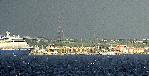
After one sea day we arrived in Willemstad early in the morning of January 22. Occupied by Arawak people when the Spanish first arrived in 1499, Curacao was taken over by the Dutch in 1643. It became one of the most important slave depots in the Caribbean (until slavery was abolished in 1863) and developed a shipping industry as well. It gained autonomy within the Dutch commonwealth in 1954 and independence in 2008. Today its biggest industry is tourism.
Willemstad is divided into two parts by St Anna Bay, a narrow but deep inlet from the ocean. On one side is Punda (Point), the old Dutch settlement that is a UNESCO World Heritage site, and on the other is Otrobanda (Other Side). We were docked in the cruise ship port in Otrobanda. We think this was our fifth visit to Curacao (but only three previous visits are in the blog):
https://baderjournal.com/2014/05/01/southern-caribbean-part-2-oranjestad-aruba-willemstad-curacao/
https://baderjournal.com/2019/12/30/
Curacao is a particularly enjoyable place to visit, both colorful and interesting. On this day there was quite a bit of wind as we walked from the ship toward Punda with surf pounding the rocks along the waterfront near the ship, something we had not seen before.

Our primary objective on this visit was to see the inside of the old synagogue of Curacao. We had seen the outside before but had never had the opportunity to go inside. This time we succeeded.
From the ship we walked to the Queen Emma Bridge, a swinging bridge across the St Anna Bay to Punda. The short walk from there to the synagogue took us past an art installation of flowers on a wall and a store that seemed to be selling a foot fungus (we didn’t shop there). Also an installation near the bridge called “Punda Love Hearts,” three large heart shapes in a row covered by locks, apparently attached there for good luck by couples. The island was named Curacao in 1499 for the Portuguese word for “heart,” so perhaps that had some influence on this installation too.


The Mikve Israel-Emanuel Synagogue is said to be the oldest continuously operating synagogue in the Western Hemisphere. It was opened in 1732 to serve a Sephardic community that had originally arrived in the middle of the 17th century to escape the Inquisition. Most came from Amsterdam, having previously fled there from Spain and Portugal, but we think that some came from Recife after the Portuguese reclaimed that part of Brazil from the Dutch and re-imposed the Inquisition there. This building is also known locally as the Snoa, a local variation of Esnoga, the Sephardic word for synagogue. This synagogue is said to have been modeled on the Esnoga in Amsterdam and we could certainly see the resemblance, full of polished mahogany, brass and silver. You can see our visit to the Amsterdam Esnoga here:
https://baderjournal.com/2014/08/26/amsterdam-netherlands-day-2/


Notable items inside the synagogue were an old wall clock with Hebrew numbers and a beautiful pipe organ in the balcony, where a choir also sits during services. As we understand it, Sephardic congregations like this did not require women to sit in the balcony as Orthodox Ashkenazy congregations did. The floor of the synagogue was covered in sand, which is supposed to symbolize the Israelites’ 40 years in the desert after Moses led them out of Egypt, but was also a precaution during the Inquisition to muffle footsteps in order to protect the privacy of the service.


On the other side of the courtyard from the synagogue was a museum recounting the history of the Jews of Curacao and of the synagogue. Sadly, photography was forbidden in the museum. But outside the museum entrance was part of the remains of a Mikvah, a ritual bath, that was probably installed in the mid 17th century and was in use until about 1870. The street outside was actually named for the bath. The top part of it was rediscovered during renovations in 1969, but this was just the portion where water flowed into the Mikvah and it probably had steps down to a lower level where bathing actually occurred.
Also in this area of the courtyard were some gravestones (which may have been reproductions). If the one shown below makes you think “Live long and prosper,” there is a good reason for that. It depicts two hands as a Rabbi would have held them to impart a blessing. Leonard Nimoy said that his inspiration for the split fingered Vulcan hand gesture was his Rabbi’s use of this hand position when Nimoy was growing up.

 gravestone")
Last we have a view of the courtyard from the museum entrance, a view of the synagogue from the courtyard, and the outer street side entrance to the synagogue as we left.


After leaving the synagogue complex we walked along a canal nearby toward our favorite lunch restaurant, which had been closed during the pandemic but we hoped someone would have opened it again. Along the side of this canal is the floating market, a long row of fish and produce stands with boats moored behind it. These boats belong to Venezuelans who sail the 40 miles to Curacao each day to sell their wares then return to Venezuela before night. The first time we were here the boats lined the canal all the way to the end of the market, but since the pandemic and the troubles in Venezuela not as many come. There seemed to be more on this visit than there had been in the last few years but perhaps not.


This canal has several Dutch style drawbridges, similar to some we have seen in Amsterdam. When we arrived at our restaurant it was still closed up and locked, but at least the “for sale” sign we saw last time we were here was gone so maybe someone is getting ready to reopen it. We hope so because it is a fun place to eat, set right out over the water in a small lake at the end of the canal. On our way back toward the bay to find another restaurant for lunch we walked by a long row of trees with interesting trunks (possibly live oaks?).


 future restaurant")

We ended up eating Chickenburgers (much tastier than it sounds) at The Iguana, an outdoor restaurant on the edge of the bay in Punda where we had lunch last time we were here. It has an unrivaled view of the bay and the Queen Emma swinging bridge. Docked across the canal was the Ambience, a cruise ship operated by the Ambassador line. It has a capacity of 1400 passengers and started life as the Regal Princess in 1991. We were told it is also on a world cruise, but we are not sure that is true.

We were glad to be under cover in the restaurant because it started raining while we were eating. We moved to a table further from the edge and finished our meal. Meanwhile the Queen Emma bridge slowly opened to permit some ships to pass and came to rest along the opposite side of the bay. The little yellow building on the end of the bridge is the pilot’s house, where the engines that move the bridge are controlled. We had quite a nice view of this process and weren’t inconvenienced by it as were those who wanted to cross to Otrobanda. When the bridge is open the only way to get across is in a ferry boat, which many did.


After our late lunch we returned to the ship the same way we had come in the morning, finding a Celebrity ship docked behind us. When Zuiderdam sailed away around 6:00 Curacao bid us farewell with a nice rainbow.


St George’s, Grenada (2024)
We reached Grenada (the “a” is long, as in lemonade) on January 30. When Christopher Columbus first sighted this island in 1498 it was inhabited by Carib people, who had taken the island from the Arawaks living there before. The French conquered the Caribs in 1652, virtually wiping out their population, and the island thereafter passed back and forth between the French and English. Grenada remained British, however, from 1784 until it obtained independence in 1974. The month after our visit Grenada would commemorate the 50th anniversary of its independence and signs and decorations were already in evidence for that occasion. Many Americans know about Grenada primarily because of the US military intervention in 1983, a few days after a coup that the Reagan administration thought might result in a government allied with Cuba. Our guide told us that most Grenadians are grateful for the US action, but his tone suggested to us that he was not one of them.
 docked in St George's")
We docked at St George’s, the capital of Grenada, which was founded in the early 18th century. Today it is home to more than 110,000 people. On our previous visit here, in 2014, we walked around the town, eating lunch in the Carenage (the horseshoe shaped harbor) and climbing up to Ft George, among other things. You can read about that and see pictures here:
At that time the extensive damage from Hurricane Ivan in 2004 was still evident. For example there were several prominent buildings without roofs and looking like old ruins. Today many of those have been restored and the whole town looks like it is pretty much back to normal. Notably, St Andrews Presbyterian Church (which we seem to have mislabeled as Anglican in 2014) appears to have been rebuilt entirely around its old bell tower so that it now apparently faces the opposite direction.
 in 2014")

So having explored the town on our last visit we decided to join an excursion that would show us around the island this time. For our first stop we drove up a steep road to the top of a large hill overlooking the city to visit Fort Frederick, one of four forts built here by the French (and later completed by the English) in the late 18th century. While the French thought these forts could be instrumental in defending the island from the British, the British recaptured it only a few years later. As you can see in the first picture above Fort Frederick has a commanding view of the coast, but its guns were installed “backwards” as they say here, facing land to the east from which it was thought an invasion would come. A sign at the fort notes that it is one of the few forts in the world “which has never fired a shot in anger.” The main reason to visit here today is the wonderful vista overlooking the city and the surrounding area.

")
Among other things we could look down on Ft George, which we had visited last time but was closed for restoration on this visit and covered with construction tarps. Of course we had a view of the Carenage and of the ship at its dock and the church (see above). Right below the fort is a prison.


Next we had a long drive to visit an orphanage, the Queen Elizabeth Home For Children. Grenada is a very mountainous island and this drive took us through the lush green mountains to the village where the orphanage was situated. We all left the buses and walked to a covered outdoor pavilion where the children (probably 4 to 8 years of age) sang a few songs. We were told not to photograph the children and not to walk on the grass (though some did both). We wondered why this was a stop on the excursion since nothing much happened, but the grounds were nice and had pretty flowers and plants.


Grand Etang Crater Lake sits in a volcanic crater created between 15 and 25 thousand years ago. It is pretty but not very large as lakes go. As Nyron, the shore excursion director said, if you live in the US or Europe you might have a very different idea of the word “Grand.” The lake is located in a forest reserve established in 1906 that includes numerous hiking trails. What we liked best about the lake was the tall grass growing in its shallow areas (although the deepest part of the lake is only about 20 feet deep). The hills around the lake are the walls of the volcano’s caldera.


")


Among the wildlife living near the lake are Mona monkeys. We didn’t see them, but our friend Robert did and shared his pictures with us. There were also some nice flowers in the reserve.
")
")


Driving through the mountains and countryside we passed houses in villages and by themselves. Some were interesting, some not so much. Lots of external staircases and 2d floor verandas.


We had a tour of the rum distillery at River Antoine Estate, which was established in the late 18th century. Our guide was very proud of the fact that this is the only distillery still producing rum in the traditional manner, without machinery (except for bottling) or chemicals. This distillery is also powered by the oldest continuously working water wheel in the Western Hemisphere. We saw the processing from sugarcane to fermentation in a vat room to distilling in three connected enclosed vats (one of which said it was made in Kentucky).


 & Bill (right) on walkway overlooking vat room")


After the tour we were given rum to sample. They had two varieties: 75 proof and 69 proof (if we remember correctly). We were told they began producing the 69 proof after the 911 terrorist attack when alcohol more than 70 proof was designated as a potential terrorist explosive. They told us we would be able to taste the difference, but Rick tried both and could not tell the difference (both samples burned too much to actually taste).

We had a buffet lunch at a restaurant on the estate. The food was good but it was much too crowded since there was a HAL tour eating there at the same time. The restaurant building was open to the surrounding countryside and there was a field of sugarcane nearby whose fate will undoubtedly be found in the distillery. The highlight of the meal was a dessert of nutmeg ice cream, which we had on our prior visit to Grenada but have never seen anywhere else.


Grenada is called “The Spice Island” because of its output of spices for export. The prime spice produced here is nutmeg, which was brought here from Asia in the 1840’s. The nutmeg fruit produces both nutmeg and mace. Today Grenada produces about 20% of the world’s nutmeg and some 30% of the population here receives income from this industry. We visited the Nutmeg Museum on our way back to the ship, but there really wasn’t much of interest there, a disappointment to us.
Driving back toward the port we stopped to look at some mango trees (we think) and ripening bananas. We drove past an old plantation house and also the beach where the U.S. marines first came ashore during the intervention in 1983 (but we were going too fast to take a picture). In the distance behind a jut of land we could see our ship docked next to the much larger P&O Britannia, whose passenger capacity is almost twice that of the Zuiderdam. The P&O ship was docked starboard of our ship and, since our cabin is also starboard, we had a wonderful island view from our balcony all day long (see below).
")


As we sailed away from Grenada in late afternoon we could see the national sports stadium (built by the Chinese) and a nice view of the island. One more stop in the Caribbean to come.


Sailing the Amazon on the Zuiderdam (2024)
After a brief interruption to lament the loss of the Mediterranean portion of our itinerary (see previous post) we now return you to our regular programming
_________________________________________________________________________________________________-_____
After leaving Santorem on January 16 we spent January 17 sailing down the Amazon to the ocean. We dropped off our pilots at Macapa early in the morning (before we were up), crossed the Amazon bar late in the day, then spent two more sea days to reach our next port. So this seemed like a good place to sum up our Amazon river experience and also show a little about what is on board the Zuiderdam.
I am not going to bore everybody with a lot of statistics. It is enough to know that the Amazon is easily the biggest river in the world, transporting more water to the ocean than the next 3 largest rivers combined. It is about 200 miles wide at its mouth and, as we may have mentioned before, there is an island in the river near its mouth that is bigger than Switzerland. The Amazon is a very muddy river and a lot of flotsam can be seen floating by, much of the mud and flotsam having travelled from the Andes some 3 or 4 thousand miles up river. The river is wide enough that you often can’t see the shore, sometimes on either side, so it looks almost like being in the ocean.

What gives it away that this is a river is the muddy color, very brown on this visit. The color of the ocean was a significant change once we left the river behind.

The river’s shore is mostly lined with deep green rainforest that looks almost impenetrable, extending for miles and miles as you sail along. But here and there you can also see small houses and out buildings, each one of which has a river boat tethered nearby because that is the only way for them to go anywhere. When travelling on a riverboat for more than a day the locals sleep onboard in hammocks strung on the deck.


Since this entire area is a giant rainforest it is no surprise that there are clouds much of the time. We have seen many spectacular cloud formations rising high into the sky from the fairly flat landscape around the Amazon.


One thing the Amazon has in abundance is insects, some of them quite large. On our first trip here in 2012 there were a number of them sitting on the walls of the ship that were several inches long and very nasty looking. On this trip all we have to show is a moth sitting on a window, but a pretty big one. Several times early in the trip we thought we were seeing meetings of the waters, but we discovered that when the lines between muddy and not muddy are irregular this may actually be caused by shadows thrown on the Amazon waters by the clouds. It looks interesting anyway.


In sum, sailing the Amazon is quite an experience with many aspects you probably wouldn’t experience on any other river. We want to note that, while we have made much of the low water in the river on this trip, we were pretty lucky about that because a month or so earlier the water was so low that several ships cancelled their river cruises. We are told that navigation was pretty tricky this time, and the Captain seemed very glad to have the river pilots to help find the deeper channels and avoid the sand bars, but the low water never interfered substantially with our itinerary although we did anchor further away than previously at several ports. Our other visits here were both a month or two later in the year so the water at this time of year may have been lower anyway (the Amazon rises and falls some 40 feet between rainy and dry seasons even in normal years). So congratulations to Captain Van der Hoeven for bringing us through without a hitch.

We also want to give a brief idea here of some aspects of life aboard the Zuiderdam. The ship has many venues where an amazing variety of activities are usually going on throughout the day and evening. The Crow’s Nest on deck 10 at the top of the ship extends the full width of the ship and has panoramic windows showing where we are headed, with comfy chairs all along the viewing area. There is a coffee bar, a game room and the shore excursions desk is here. Parties often occur here as well.

Zuiderdam also has a small library. It is nice HAL is moving back toward having ship libraries, although they used to be much nicer places to sit and read. Maybe libraries like that will return eventually.


Deck 9 gets a lot of visits because of the Lido Buffet, where we usually get lunch. Just outside the buffet is the main swimming pool, with a sliding roof and a polar bear mother and child at one end (the baby is almost 25 years old but hasn’t grown an inch). There are lounge chairs and tables around the pool area where we usually sit to eat our lunch.

In addition to the shows by guest artists and the Zuiderdam Singers And Dancers on the Main Stage, there are several musical venues around the ship active in the afternoon and evening. Billboard Onboard is a pair of pianist/singers often called “dueling pianos” but really complementary ones. Rolling Stone Lounge has (as you might expect) a loud and entertaining rock band with two singers. We frequent two other venues. First is the Ocean Bar which features a jazz trio of piano, bass and guitar called Third Avenue West. The guitarist and bassist in particular are really good jazz musicians and they play a laid back type of jazz appropriate to their instrumentation. Some familiar ditties but also some pretty challenging jazz compositions.
 Before dinner we often attend a recital in the Explorers’ Lounge by a classical trio consisting of piano, violin and cello. Their skill is more what one would expect at a concert venue than on a cruise ship. All are graduates of leading conservatories and so far they have presented a different program every day. Among the highlights were three of Bach’s solo cello suites and a program of music recently uncovered by the pianist as part of his doctoral studies that was composed by a prisoner in Dachau concentration camp during World War II. They have drawn sizeable audiences when we have been there. What a great way to build up to a delicious dinner in the Main Dining Room (and the food really has been delicious so far on this trip).

When a ship visits a new port for the first time there is usually a welcome ceremony and the ship is presented with a commemorative plaque (or something similar). That actually happened a few days ago as I write this. Many of Zuiderdam’s interesting plaques from these ceremonies are hung in a curving stairwell between decks 2 & 3.

Past HAL ships on which we have sailed had notable art collections,including very old pieces and many from faraway countries exhibited throughout the ship. This one instead has a rather quirky art collection, including some old Dutch prints, some paintings of old HAL ships, but also more contemporary things. Outside the Rolling Stone Lounge are some interesting paintings of old Rhythm and Blues musicians, including what we think is a portrait of BB King on stage. Near the elevators on several floors are sculptures that appear to represent Renaissance entertainers. We should note that there are midships elevators on each side of the ship made of glass, so you can watch outside as the world and the decks and the tenders go by while you ascend or descend. They are fun.
")


Not far from the plaque stairwell pictured earlier is a series of six interesting art constructions. The artist, Volker Kuhn, calls them Viewboxes. Each box is about 10” x 14” and contains a bit of rather whimsical sculpture. The lighting inside each box slowly changes color from white to red to blue. We found them interesting, but I am not sure the flat pictures here do justice to these three dimensional creations. I hope I have the correct title for each work (from left top to right bottom): Music In The Air; Heavenly Joy; Way To The Stars; Off We Go.


On deck 2 are a number of glass sculptures that we found attractive and interesting.

")
During these sea days at the end of the Amazon we had a Formal Night. There used to be more of these on Grand Voyages, but now there are about two per month. Diners at all the restaurants on board, except the LIdo buffet, are required to dress up in semi-formal attire for these evenings. Some men wear tuxedos but most wear a suit (although Rick has always worn a sport jacket and tie with no problem) and women dress in cocktail party clothes. There are other nights called “Dressy Nights,” and really it is unclear what the difference is. On most formal nights there is a show on the Main Stage by the Zuiderdam Singers and Dancers, and sometimes they leave us pillow gifts, found on the bed when you return to your room. It used to be that towel animals were left on the bed almost every evening but now that only happens on formal and dressy nights. On this formal night the dining room crew made nice red and black birds as table centerpieces out of napkins and wine glasses.

")

")
So that’s all we have for this short intermission from the relentless parade of port stops. Next episode will be another port as we headed toward the Panama Canal.

