
Around The World In 115 Days
On January 5 we will set sail on the Amsterdam, Holland America’s co-flagship. It is a medium sized ship with a capacity of 1300+ (although we expect a lot fewer than that on this voyage). The title above, obviously cribbed from Jules Verne’s book, is original in the sense that I (Rick) made it up. Since I made it up, however, I have seen it used by several other people who independently made it up (indicating its pretty obvious & not very clever). I considered dropping it, but what the heck . . . it’s my blog & I did think of it on my own. So, there it is.
There should be quite a lot of interesting stuff on this voyage. We will be going through both the Panama & the Suez canals. We will visit lots of churches, mosques & temples. We will see elephants & camels & kangaroos. We will see islands, mountains, deserts & The Great Barrier Reef. So if our ship is not scuttled by an El Nino induced cyclone, and we are not done in by pirates or terrorists along the way, we expect to be back home in May with a new appreciation of parts of the world we have never seen before & some interesting stories to tell. Of course, many of those stories & all of our best photos will be available to all on this blog. So welcome aboard.

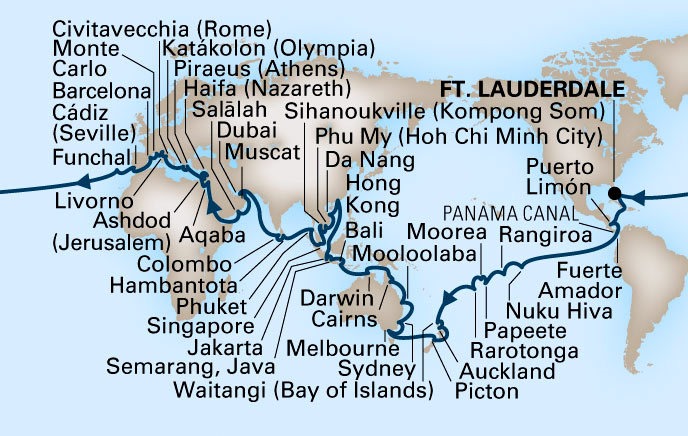
Above is a map of our itinerary, & below is an easier to follow listing of the ports & sea days (note that if you hover your mouse cursor over a picture a caption will pop up). Of course, this is the planned itinerary; experience tells us that there will be changes along the way due to such things as weather or local political unrest. But not too many, we hope!
Day |
Date |
Port |
Arrive |
Depart |
0 |
05 Jan 2016 |
Fort Lauderdale, Florida |
11:00 PM |
|
1 |
06 Jan 2016 |
At Sea |
||
2 |
07 Jan 2016 |
At Sea |
||
3 |
08 Jan 2016 |
At Sea |
||
4 |
09 Jan 2016 |
Puerto Limon, Costa Rica |
07:00 AM |
04:00 PM |
5 |
10 Jan 2016 |
Enter Panama Canal at Cristobal |
05:00 AM |
05:00 AM |
5 |
10 Jan 2016 |
Cruising Panama Canal |
||
5 |
10 Jan 2016 |
Exit Panama Canal at Balboa |
07:00 PM |
07:00 PM |
5 |
10 Jan 2016 |
Fuerte Amador, Panama |
08:00 PM |
|
6 |
11 Jan 2016 |
Fuerte Amador, Panama |
04:00 PM |
|
7 |
12 Jan 2016 |
At Sea |
||
8 |
13 Jan 2016 |
At Sea |
||
9 |
14 Jan 2016 |
At Sea |
||
10 |
15 Jan 2016 |
At Sea |
||
11 |
16 Jan 2016 |
At Sea |
||
12 |
17 Jan 2016 |
At Sea |
||
13 |
18 Jan 2016 |
At Sea |
||
14 |
19 Jan 2016 |
At Sea |
||
15 |
20 Jan 2016 |
Taiohae, Nuku Hiva, French Polynesia |
11:00 AM |
06:00 PM |
16 |
21 Jan 2016 |
At Sea |
||
17 |
22 Jan 2016 |
Avatoru, Rangiroa, French Polynesia |
08:00 AM |
05:00 PM |
18 |
23 Jan 2016 |
Papeete, Tahiti, French Polynesia |
08:00 AM |
|
19 |
24 Jan 2016 |
Papeete, Tahiti, French Polynesia |
05:00 AM |
|
19 |
24 Jan 2016 |
Moorea, French Polynesia |
08:00 AM |
05:00 PM |
20 |
25 Jan 2016 |
At Sea |
||
21 |
26 Jan 2016 |
Rarotonga, Cook Islands |
08:00 AM |
05:00 PM |
22 |
27 Jan 2016 |
At Sea |
||
23 |
28 Jan 2016 |
Cross International Dateline |
||
24 |
30 Jan 2016 |
At Sea |
||
25 |
31 Jan 2016 |
At Sea |
||
26 |
01 Feb 2016 |
Waitangi (Bay of Islands), New Zealand |
08:00 AM |
05:00 PM |
27 |
02 Feb 2016 |
Auckland, New Zealand |
08:00 AM |
05:00 PM |
28 |
03 Feb 2016 |
At Sea |
||
29 |
04 Feb 2016 |
Picton, New Zealand |
08:00 AM |
05:00 PM |
30 |
05 Feb 2016 |
At Sea |
||
31 |
06 Feb 2016 |
At Sea |
||
32 |
07 Feb 2016 |
At Sea |
||
33 |
08 Feb 2016 |
Melbourne, Australia |
08:00 AM |
05:00 PM |
34 |
09 Feb 2016 |
At Sea |
||
35 |
10 Feb 2016 |
Sydney, Australia |
08:00 AM |
|
36 |
11 Feb 2016 |
Sydney, Australia |
06:00 PM |
|
37 |
12 Feb 2016 |
At Sea |
||
38 |
13 Feb 2016 |
Mooloolaba, Queensland, Australia |
08:00 AM |
05:00 PM |
39 |
14 Feb 2016 |
At Sea |
||
40 |
15 Feb 2016 |
At Sea |
||
41 |
16 Feb 2016 |
Cairns, Australia |
08:00 AM |
05:00 PM |
42 |
17 Feb 2016 |
Great Barrier Reef |
||
42 |
17 Feb 2016 |
The Ribbon Reef Region |
||
42 |
17 Feb 2016 |
Sherrard Island Anchorage, Queensland, Australia |
06:00 PM |
|
43 |
18 Feb 2016 |
Sherrard Island Anchorage, Queensland, Australia |
04:00 AM |
|
43 |
18 Feb 2016 |
Great Barrier Reef |
||
43 |
18 Feb 2016 |
The Far North Region |
||
43 |
18 Feb 2016 |
The Torres Strait |
||
44 |
19 Feb 2016 |
At Sea |
||
45 |
20 Feb 2016 |
Darwin, Australia |
10:00 AM |
07:00 PM |
46 |
21 Feb 2016 |
At Sea |
||
47 |
22 Feb 2016 |
At Sea |
||
48 |
23 Feb 2016 |
Benoa, Bali, Indonesia |
08:00 AM |
06:00 PM |
49 |
24 Feb 2016 |
At Sea |
||
50 |
25 Feb 2016 |
Semarang, Java, Indonesia |
06:00 AM |
04:00 PM |
51 |
26 Feb 2016 |
Tanjung Priok, Jakarta, Indonesia |
08:00 AM |
06:00 PM |
52 |
27 Feb 2016 |
Crossing the Equator |
||
53 |
28 Feb 2016 |
At Sea |
||
54 |
29 Feb 2016 |
At Sea |
||
55 |
01 Mar 2016 |
At Sea |
||
56 |
02 Mar 2016 |
Hong Kong, China |
10:00 AM |
|
57 |
03 Mar 2016 |
Hong Kong, China |
||
58 |
04 Mar 2016 |
Hong Kong, China |
09:00 PM |
|
59 |
05 Mar 2016 |
At Sea |
||
60 |
06 Mar 2016 |
Da Nang (Hue), Vietnam |
08:00 AM |
|
61 |
07 Mar 2016 |
Da Nang (Hue), Vietnam |
05:00 PM |
|
62 |
08 Mar 2016 |
At Sea |
||
63 |
09 Mar 2016 |
Phu My (Ho Chi Minh City), Vietnam |
06:00 AM |
06:00 PM |
64 |
10 Mar 2016 |
At Sea |
||
65 |
11 Mar 2016 |
Sihanoukville, Cambodia |
06:00 AM |
07:00 PM |
66 |
12 Mar 2016 |
At Sea |
||
67 |
13 Mar 2016 |
Singapore |
06:00 PM |
|
68 |
14 Mar 2016 |
Singapore |
||
69 |
15 Mar 2016 |
Singapore |
10:00 PM |
|
70 |
16 Mar 2016 |
At Sea |
||
71 |
17 Mar 2016 |
Phuket, Thailand |
08:00 AM |
06:00 PM |
72 |
18 Mar 2016 |
At Sea |
||
73 |
19 Mar 2016 |
At Sea |
||
74 |
20 Mar 2016 |
Hambantota, Sri Lanka |
08:00 AM |
07:00 PM |
75 |
21 Mar 2016 |
Colombo, Sri Lanka |
07:00 AM |
|
76 |
22 Mar 2016 |
Colombo, Sri Lanka |
05:00 PM |
|
77 |
23 Mar 2016 |
At Sea |
||
78 |
24 Mar 2016 |
At Sea |
||
79 |
25 Mar 2016 |
At Sea |
||
80 |
26 Mar 2016 |
At Sea |
||
81 |
27 Mar 2016 |
Dubai, United Arab Emirates |
08:00 AM |
|
82 |
28 Mar 2016 |
Dubai, United Arab Emirates |
11:00 PM |
|
83 |
29 Mar 2016 |
At Sea |
||
84 |
30 Mar 2016 |
Muscat, Oman |
08:00 AM |
06:00 PM |
85 |
31 Mar 2016 |
At Sea |
||
86 |
01 Apr 2016 |
Salalah, Oman |
08:00 AM |
06:00 PM |
87 |
02 Apr 2016 |
At Sea |
||
88 |
03 Apr 2016 |
At Sea |
||
89 |
04 Apr 2016 |
At Sea |
||
90 |
05 Apr 2016 |
At Sea |
||
91 |
06 Apr 2016 |
Aqaba (Petra), Jordan |
08:00 AM |
11:00 PM |
92 |
07 Apr 2016 |
At Sea |
||
93 |
08 Apr 2016 |
Enter Suez Canal at Suez |
06:00 AM |
06:00 AM |
93 |
08 Apr 2016 |
Transit the Suez Canal |
||
93 |
08 Apr 2016 |
Exit Suez Canal at Port Said |
06:00 PM |
06:00 PM |
94 |
09 Apr 2016 |
Haifa, Israel |
08:00 AM |
11:59 PM |
95 |
10 Apr 2016 |
Ashdod (Jerusalem), Israel |
07:00 AM |
06:00 PM |
96 |
11 Apr 2016 |
At Sea |
||
97 |
12 Apr 2016 |
Piraeus (Athens), Greece |
09:00 AM |
06:00 PM |
98 |
13 Apr 2016 |
Katakolon (Olympia), Greece |
10:00 AM |
06:00 PM |
99 |
14 Apr 2016 |
At Sea |
||
100 |
15 Apr 2016 |
Civitavecchia (Rome), Italy |
07:00 AM |
08:00 PM |
101 |
16 Apr 2016 |
Livorno (Florence), Italy |
07:00 AM |
07:00 PM |
102 |
17 Apr 2016 |
Monte Carlo, Monaco |
07:00 AM |
04:00 PM |
103 |
18 Apr 2016 |
Barcelona, Spain |
09:00 AM |
08:00 PM |
104 |
19 Apr 2016 |
At Sea |
||
105 |
20 Apr 2016 |
Cadiz, Spain |
07:00 AM |
05:00 PM |
106 |
21 Apr 2016 |
At Sea |
||
107 |
22 Apr 2016 |
Funchal (Madeira), Portugal |
07:00 AM |
05:00 PM |
108 |
23 Apr 2016 |
At Sea |
||
109 |
24 Apr 2016 |
At Sea |
||
110 |
25 Apr 2016 |
At Sea |
||
111 |
26 Apr 2016 |
At Sea |
||
112 |
27 Apr 2016 |
At Sea |
||
113 |
28 Apr 2016 |
At Sea |
||
114 |
29 Apr 2016 |
At Sea |
||
115 |
30 Apr 2016 |
Fort Lauderdale, Florida |
07:00 AM |
No one will be shocked to learn that we will not be the first to circumnavigate the globe. Actually, the expedition of Ferdinand Magellan was the first to complete such a journey, from 1519-1522. Magellan didn’t make it because he was killed in a foolish skirmish with the locals in the Philippines; only one ship from his fleet with 18 survivors made it back. We saw a monument to Juan Sebastian Elcano, the leader of those survivors, in Seville a couple of years ago.


Other circumnavigators over the centuries of whom you might have heard include:
* The first by an Englishman, Sir Francis Drake, in 1577-1580 (discovering the Drake Passage in South America)
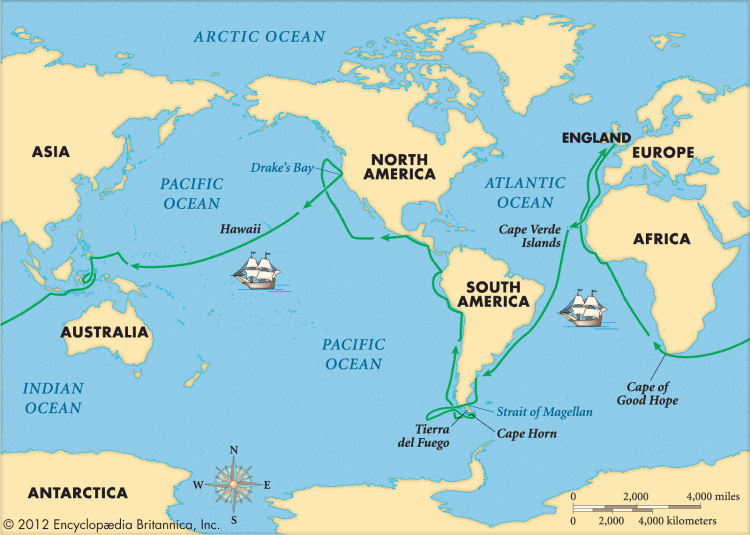

* The first French circumnavigation by Louis de Bougainville (after whom the flower bougainvillea is named) in 1766-1768. His crew included Jeanne Bare, the first woman to sail around the globe, who was disguised as a man on board.
* Captain James Cook in 1766-1771. He actually had three such voyages, but was killed in Hawaii during the third one. We will be visiting the sites of several of his stops in the South Pacific.


* Teddy Roosevelt sent America’s “Great White Fleet” around the world in 1907-1909 to assert the United States’ claim as an emerging world power.
* In 1966-1967 Sir Francis Chichester made the first solo circumnavigation of the globe, stopping in port only once.
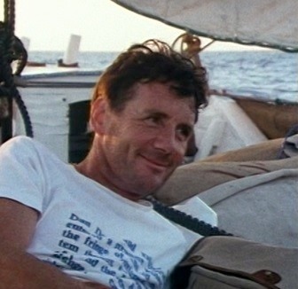
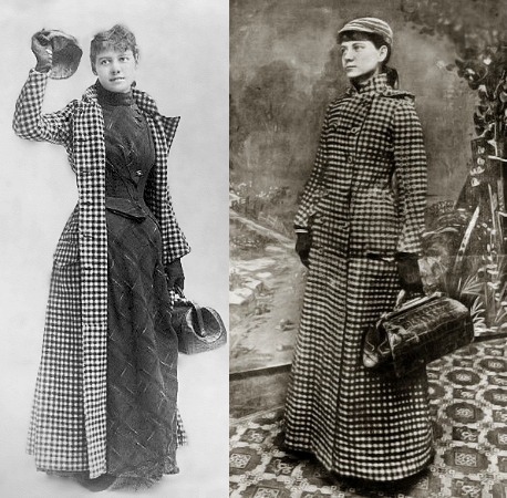
While not technically circumnavigations, there are several other well known trips around the globe at least partly by sea that are quite entertaining. One famous journey that didn’t actually take place, of course, was that of Phileas Fogg & his servant Passepartout in 1872, recounted by Jules Verne in Around The World in 80 Days. It is still a good read (even if you have seen one of the films) and if you have an ereader you can download a copy for free at http://www.gutenberg.org/ebooks/103. American journalist Nellie Bly was inspired by Verne in 1889-1890 to try to encircle the globe in 80 days and actually made it in 72, a new world record. Her trip was an international sensation, particularly since it was quite unusual at that time for a young woman to travel alone (her luggage was limited to a single small hand bag). In 1988 Michael Palin (of Monty Python fame) set out to follow Phileas Fogg’s route as closely as possible and return in 80 days. You can (and should) find out how it turned out by viewing his 1988 BBC documentary “Around the World in 80 Days,” available on DVD (we borrowed it from Netflix).



Last but not least (at least to us), Rick’s grandparents – Arthur & Freda Bleich – sailed around the world in 1954. Listening to their stories about visiting Japan, Egypt, Israel & the Taj Mahal in India is what first made me (Rick) aware that such a voyage could be done & what wonders could be seen. Of course, world cruises were a lot less common 60 years ago so this was quite exotic. They sailed on a ship called the President Monroe from the American Presidents Line, a combined cargo & passenger ship with fewer than 100 passengers (interestingly, Monroe was also their son’s name). The Amsterdam, which is fairly small by modern cruise ship standards with a capacity of 1380 passengers, is almost twice as long and about 9 times as heavy as the President Monroe, so times have really changed. Here are some pictures of them on their world cruise:


They told us they were taking this ultimate trip at that time because they were in their 60’s so their travelling days were probably over. Yet Arthur lived 20 more years & Freda lived another 50 years! It just goes to show that you can never tell when your ability to travel will be gone; it could be over sooner or later than you anticipate. So you have to see what you can while you can. At least that’s our philosophy.
Anyway, that’s enough historical background (anyone familiar with this blog knows that history is one of our primary interests). The next posting down from this is entitled “About This Blog,” which details how to go about using this website, get the most out of reading the postings & navigate its contents. There probably won’t be a lot of content here before late January because the Internet is particularly slow & often inaccessible when crossing the Pacific. And be prepared for the blog posts to fall further & further behind our real-time position as the trip goes on, but be assured that it will eventually be completed!
About This Blog (revised January, 2023)
*These are the voyages of Rick & Mary Bader. Our continuing mission: to boldly go where we have never gone before!*
*Note: Menu Button At The Top of the Page*
If you are reading this you probably already know that the “About This Blog” button will always bring up this post, in case you want to review the itinerary or the instructions for using the blog. There used to be two more buttons at the top, but it seems those are no longer permitted on this blog’s template. Workarounds:
* If you want to return to the most recent posting just put “www.baderjournal.com” into your web browser.
* If you want to see where the ship is at this minute put “www.seascanner.com/ships-position-[ship’s name] into your web browser, with the actual ship’s name (eg. Zaandam) substituting for the brackets at the end.
_______________________________________________________________________________________________________
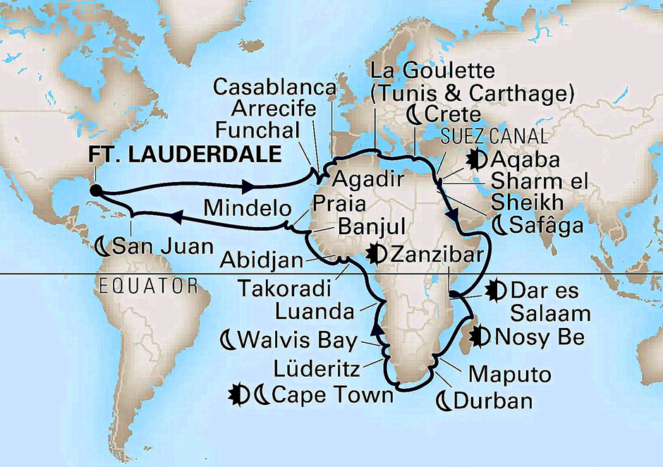
Welcome to Bader Journal, the travel blog of Rick & Mary Bader. That’s us, pictured at the top, in old travel pictures that will rotate randomly each time you open the blog, but have nothing to do with the content of the post appearing below them. This blog was created primarily for our family & friends but anyone who is interested is welcome to view it. We last set sail October 10, 2022 on a 71 day circumnavigation of Africa on the Holland America ship Zaandam. Here is a map of our itinerary:
Our posts typically contain a lot of pictures & text so they take some time to create. This can only be done on sea days, when we are on the ship & have leisure time. In addition, internet access on a cruise ship is very spotty & slow. During this voyage were unable, because of technical issues, to upload any postings to our blog. So we continued to compose blog posts as we went along (at a time when we could still remember fairly clearly what we did & what is in the pictures) but did not post any before we returned home at the end of the year.
If you want to be notified when new posts appear, read Part B below.
**One general caveat: please don’t take what is written here about the places we visit as authoritative. We do our best to be accurate but really we are mostly repeating things we have read or been told. You may sometimes note a skeptical tone when we tell you something we have heard but don’t necessarily believe, though even things we do believe sometimes turn out to be inaccurate. So, caveat emptor!
What follows is an outline of instructions for using the tools built into the blog. Use anything that is helpful to you & just ignore the rest.
A. Subscribing To Email Notifications Of New Postings:
If you scroll to the very bottom of your computer screen you will find several “widgets” in 4 columns. In the second column from the left (next to the calendar and above the orange RSS buttons) is a button to subscribe to email notifications of new postings. If you sign up you will receive an email right after a posting is published with a link to the new blog page, so you won’t have to waste time on the internet looking for one that isn’t yet there.
B. Navigating the Blog:
1. Google: The easiest way to find a particular post is to use Google. If you google “Bader Journal” & the place in which you are interested, the posting on this blog should be one of the first results listed (e.g. “bader journal rome” will bring up our posts about visiting Rome). If we have visited that place more than once, all those visits should appear in the google results.
2. Blog tools: At the bottom of your computer screen you will find several widgets (probably overkill) that may (or may not) be useful in navigating the blog:
a. In the left position is a calendar on which the posting dates of blog entries are blue. Click a blue date with your mouse and that day’s post(s) should pop up to the top of the blog.
b. Next to that is a section with three items. The first is the email subscription described above. The middle one has two orange buttons for subscribing to RSS feeds of the posts and/or the comments (We have no idea how well – if at all – those work). The bottom one is a search function that should allow you to find a previous posting by searching for a particular word or phrase in the text (e.g. “camel” or “Peru” or “Alhambra”).
c. In the right hand position is a list of the 5 most recent posts; click on one to bring it to the top.
d. Second from the right is an “Archives.” After the name of each month is the number of postings during that month. Click on a month to bring up that month’s blog postings. This is probably the easiest way to access all of one of our previous voyages on this blog, which I will list here as a sort of table of contents (note that the dates indicated are when the posts went up on the blog, not when we were sailing on the cruise):
— First South America & Antarctica Voyage posts can be found at December 2011 through March 2012:
![image[4]](https://baderjournal.com/wp-content/uploads/2022/06/image4.png "image[4]")
— Grand Mediterranean Voyage posts can be found at March through October 2013:

— Southern Caribbean posts can be found at April through May 2014:

— Voyage Of The Vikings posts can be found at July through September, 2014:

— First World Cruise posts can be found at December, 2015, through July, 2016:
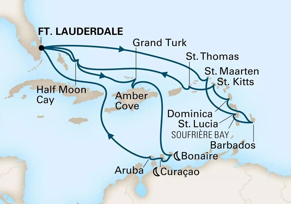
— Alaska Cruise costs can be found at August, 2017:

— Second World Cruise posts can be found at January through September, 2018:

— Second South America and Antarctica posts can can be found at January, 2019 through January, 2020:
— Caribbean Journey posts can be found at June and August, 2022:

C. Viewing Picture Captions
The pictures posted after 2021 have captions, but they are not visible in the Blog’s text. (Earlier pictures had captions too, but it appears they aren’t accessible any more). If you hover your mouse cursor over a one of these picture a caption should pop up that will contain some identifying information and sometimes more substance as well. The popup is temporary; if it closes before you finish reading it just move your mouse away and then back over the picture and it will pop up again. This works on a computer browser using a mouse, but we don’t know how or whether it will work on a tablet or phone or RSS feed.
D. Comments
Last, but far from least, at the end of each posting is a small blue text button reading “Leave a reply.” If there have already been comments posted it will read “[number] responses,” but you can still click on Leave a Reply to add yours. Comments are heartily welcomed! If you want to leave a public comment (this blog can be found on Google & has, to our surprise, been viewed by many people from all over the world) then use the “Leave a Reply” button & your comment will become part of the blog (and will also be sent to Rick by email). But if you would rather communicate privately with us – about the blog, about something else, or just to say hi – then you can use our regular email addresses. When on a cruise we read our email semi-regularly (depending on our schedule & how well the internet connection is working) so a response (if one is called for) may take a while.
St. John’s, Newfoundland, then home
The morning of August 13 found us docked at St. John’s, the capital and largest city (about 100,000) of the province of Newfoundland and Labrador. It is also the easternmost city in North America (not counting Greenland). While it was incorporated only in the 1920’s, Europeans have been living here since the 16th Century. The name may have come from the Feast of St. John the Baptist, which was reputedly the day in 1497 that John Cabot became the first European to set foot here. While it was first claimed by the English in the late 16th Century the town was subsequently attacked several times and briefly held by the Dutch and the French. The last battle of the French & Indian War was fought here.

Well, it had been a long trip & we were both still under the weather so we decided to just walk around town for a few hours & then spend some time relaxing on the ship. It was a very gray & sometimes drizzly day but St. John’s is a city of very colorful buildings that kept it from being too gloomy.


In addition to spending time in some of the shops on the first couple of streets from the harbor we passed the massive grey stone St. John’s Courthouse, built in 1904.


Further down the street we came upon the National War Memorial. Dedicated on July 1, 1924 by British World War I Field Marshal Douglas Haig plaques have since been added on its side commemorating Newfoundlanders who died in World War II, the Korean War & Afghanistan. Since Newfoundland did not become part of Canada until after World War II, the “National” in its title refers to the old Dominiion of Newfoundland rather than Canada. Around the memorial were wreaths dedicated mostly to regiments, perhaps because the 100th anniversary of the start of World War I was only a few days before we visited. The monument was located on a plaza with a broad stairway that was ringed by old metal lights topped by white glass globes.


We walked further up the very steep hill. St. John’s is sometimes compared to San Francisco partly because of the steepness of its streets & its colorful houses..


Up the hill we visited two churches named (as the city was) for St. John the Baptist. At the very top is the Catholic Basilica-Cathedral of St. John the Baptist., considered the mother church of Roman Catholicism in Newfoundland. It was built in the middle of the 19th Century. Imposing on the outside with two prominent bell towers, at the time of its completion it was the largest church in North America. On a balcony is a pipe organ with more than 4,000 pipes. Beneath the altar is a sculpture of “The Dead Christ.”


Since the Basilica is on the top of the hill its front steps give a fine view of the city’s large harbor, which is well protected from the sea.


We walked down the hill to the other cathedral named for St. John, this one Anglican. While it lacks the dramatic stature of the Catholic cathedral on the outside we thought the inside of this one had more warmth and interest. Begun in the middle of the 19th Century and completed in 1885, the church was badly damaged in the Great Fire of 1892. Rebuilding was completed in 1905, although it still lacks the spire it was originally designed to have. The congregation is currently raising funds to build one. The church says that this parish, founded in 1699, is the oldest Anglican parish in North America. This church also has an impressive pipe organ with four banks of pipes, two of which appear to have been added on.


We were getting tired by now, with all the up and down walking, so we finished our shopping and headed back to the ship. Throughout the day we passed a number of nice flowers (not wildflowers, this is a city), along with a very unusual utility box & more colorful buildings.


The ship left St. John’s at about 3:00. We were told that as we sailed past Signal Hill we would be saluted by musket fire. We were, but I could not see the shooting even though I scoured the top of the hill. It must have been coming from somewhere else, maybe the hill on the other side of the ship. Anyway, Signal Hill is where the fortifications defending the harbor stood for several hundred years. The last battle of the French and Indian War in 1762 was the Battle of Signal Hill. Its name stems from a signal flag mast that was used to signal the town when a ship was coming. The Cabot Tower was built there at the end of the 19th Century to commemorate the 400th anniversary of John Cabot’s initial visit and also Queen Victoria’s Diamond Jubilee. On December 12, 1901 Marconi received the first transatlantic wireless transmission on this hill, sent from Cornwall in the United Kingdom.


We sailed out of the harbor, past some birds on a cliff and some rocky waterfront cliffs. The next day we were in Bar Harbor, Maine. But we were still feeling poorly and we had been there before and weren’t very interested in seeing it again. Besides, it was a very gray day, it was a tender port and we had to pack and prepare to disembark in Boston the next morning. So we took a pass on Bar Harbor & spent a relaxing day on the Veendam. Disembarking in Boston the next morning, August 16, we retrieved our car from the motel where it had spent the trip & drove home. It was a long drive, but we were very happy to be in our own be again after a long and rewarding trip.


St. Anthony, Newfoundland
We anchored in the bay at St. Anthony on the morning of August 12. It was chilly and gray. We were anchored a good way from the town in this large harbor, with the red & white lighthouse at the entrance to the rocky bay the most interesting sight nearby.


We tendered into town but didn’t stay there. St. Anthony is a small town (fewer than 2,500) with little to see, so we signed up for an excursion to the real reason for coming here, L’Anse aux Meadows. This is an archaeological site of a 1,000 year old Norse village, the first (and only, so far) actual proof that the Vikings reached North America 500 years before Columbus.
The Icelandic Sagas tell of Leif Eriksson (whose statue we saw in Reykjavik) leading a group on a voyage to the west of his home in Greenland to a spot he called Vinland. The Saga of the Greenlanders and the Saga of Erik the Red (Erik was Leif’s father and the leader of the first Viking settlement in Greenland) are both pretty short and make good reading for anyone interested in this stuff. The Sagas indicate that the settlement lasted only a few years & was abandoned because of internal fighting among the Vikings and conflict with the locals, who the Norse called Skraelings.
But the Sagas are not real history in the modern sense and the idea that another European had reached America before Columbus was dismissed by most people. A Norwegian named Helge Instad read the Sagas, however, and concluded that Vinland was real and was probably located in Newfoundland. He went to northern Newfoundland and began asking around about any mounds in the area. One of the locals told him about some mounds thought to have been Indian remains. Instad and his wife, Anne Stine Instad, excavated the mounds in 1960 and found remains that turned out to be a Viking settlement. Anne led excavations there from 1961 to 1968, and proved that the settlement was Norse by finding a bronze Viking cloak pin among the ruins. As a result, today it is accepted that L’Anse aux Meadows was an 11th Century Viking settlement and that Columbus was not the first European to reach the Americas.
We boarded our bus and headed out with our knowledgeable and very engaging guide Chris. This is a remote area with no modern tour busses so we made the trip in school busses, which were less than comfortable.


The archaeological site, now a Canadian national park, has a reconstruction of how the village most likely would have looked. But about a mile away is a redundant reconstruction run as a private business, sort of a Disney-like “Vikingland” (although a lot smaller & without the rides & concessions). For reasons that are beyond me (unless they involve monetary incentives) we went first to the private site where we spent too much time on an entirely unnecessary visit. The time would have been better spent in the visitor center at the national park where we had insufficient time to review all the exhibits. Both of these sites, however, are located on a lovely bay that shows why the Vikings would have found it a good place to settle.


We drove the mile or so to the national park and walked to the visitor’s center. There was Viking themed artwork along the path, including busts of the Instads. In the visitor’s center we saw a film then had a little bit of time to look at the exhibits & the gift shop. From the porch of the visitor’s center was a great view of the whole area around where the Vikings settled.


Walking down the boardwalk path to the site we first came to a two part sculpture called Meeting of Two Worlds. It is a rather abstract representation of the first encounter between Europeans on one side with Americans on the other.


After each year’s excavations the site was buried again to protect the remains from the elements. Today all you can really see of the actual remains is a series of grassy mounds outlining the foundations of the original Viking buildings. Each has been identified but I can’t identify which buildings are in most of these pictures. The first one is where iron was smelted and worked (it’s obvious since it’s labeled) but apparently only enough iron for a few hundred nails was produced here. The multi-roomed structures were Viking longhouses, which generally housed several people and had connected outhouses for animals and work. Three longhouses have been recovered on the site. There are also a few smaller one-room huts, probably housing slaves or crew of low status, although one had weights suggesting it might have been a weaving workshop for women.


We visited the reconstruction of what the Viking buildings probably looked like. There were a couple of tents near the shore that looked like they might have been for storage. The other buildings had turf roofs over wooden walls with turf outside of them that made the building look like a hill from a distance. The exposed walls were covered with piled up peat rectangles which we were told would have an insulation value in modern terms of about R-100. I imagine that kind of insulation would be pretty welcome during the winter this far north. There were costumed people demonstrating the crafts that would have been practiced here by the Norse. When the Norse lived here this area was thickly wooded so that wood was plentiful for building. You will recall from earlier episodes that the opposite was true in Greenland, where trees are pretty much nonexistent. The Sagas say that Leif loaded his ships with wood each time he returned to Greenland, which must have been a very valuable cargo to sell there.


There were a lot of what looked like wildflowers in this area, although since these are carefully reconstructed sites who knows whether they were planted here initially.


Current thought is that this site was more of a way station for exploration further south than a village intended as a permanent settlement. But in any event, the Vikings only used this site for a few years & burned it when they left, presumably to deny its use to others. But its historical importance is not diminished by its relatively short duration.
So the Vikings left this spot and we did too, driving back to St. Anthony in time to permit just a quick look around. It seems to be a nice town with nice people. On the road to the Viking site we passed several very large piles of cut wood, some with vehicles parked nearby. Chris told us that no one ever steals wood from someone else’s cache and that they often leave the keys in their vehicles. But if anyone is in need of wood (or other supplies) they only have to ask and people are glad to share. There are Just a few modest buildings in the harbor area. Chris informed us ruefully that there isn’t even a place in town where you can sit down and have a beer! Perhaps the largest building in the area is the hospital, just up the hill from the harbor, which has a 360 degree ceramic mural by a well known Canadian artist named Jordi Bonet who was born in Spain. When we were returning from the hospital Chris was heading back to his car & he crossed the street to offer us a personal driving tour of the town, gratis. It was getting late, so we gratefully declined, but you see what I mean about the friendly folks here.


Qaqortoc, Greenland
I woke up in what seemed the middle of the night but was actually about 5:00 AM on August 10. I decided to peek out from between the curtains to see how bad the fog looked. It had been consistently bad the previous evening and the fog horn was blowing well into the night. To my surprise there was no fog at all. Instead there was a beautiful Greenlandic sunrise in progress.


We anchored outside of the small harbor at Qaqortoc about three hours later. With a population a little over 3,000 this is the largest town in southern Greenland. People have inhabited this island for some 4,000 years but Qaqortoq was founded in the late 18th century by the Danes who called it Julianehaab after their queen. It is not far from the spot where Erik the Red established the first Norse settlement in the 10th century. As best I can tell, the town’s name seems to be pronounced “kay-ker-TAWK.” I think it is the first time I have ever seen a word with 3 q’s and no u’s.

We had already explored an Inuit town in Greenland (Nanortalik) and since there are no roads out of Qaqortok there were no land excursions available. So we signed up for a boat tour arranged by a fellow passenger that was to take us to the Twin Glacier on the mainland of Greenland where it is possible to approach close enough to actually touch a piece of the Greenland ice sheet. Yesterday we cruised through Prins Christian Sund & saw icebergs from the ship’s decks above; today we would be right down in the water with them. So we tendered into the harbor where we found our tour guide and the two boats for our trip.


The man who was originally supposed to be our guide was out of town leading a group hunting reindeer with crossbows (really), so his wife Metta acted as our guide. She approached me as we emerged from the tender looking lost & asked if we were the group going to the ice cap. She was wearing a sort of snugli in which was her infant son Olaf. Quite the undertaking, we thought, in those conditions. Metta is originally from Denmark. She told us that when Olaf was on the way she was told that she could only stay in Qaqortoq to give birth if there was no chance of any complications. Because they were not able to rule that out she had to spend her last few weeks in Nuuk where apparently there is a better equipped hospital. That’s a pretty good indication of how isolated this town is, only accessible from other towns by helicopter and, in summer, by boat. Metta told us that she and her husband are planning to move to a much smaller village which will benefit his hunting business.


There were about 20 passengers in our boat, which was the larger and faster of the two. There were seats inside with good windows but you could also walk outside to see things better. As we made our way out of town and around toward the passage leading toward the glacier we passed large icebergs and mountain views in the early morning sun.


Now came one of the highlights of the day, if not of the whole cruise. The Inuit men running the boat spotted a whale spouting near the shore & turned the boat that way to get us a closer look. Usually when you see a whale in the ocean you only see a little of its back and maybe its tail as it dives (you have seen my pathetic pictures of this), but this humpback whale was rolling around on the surface blowing its spout for quite a while. It seemed almost like he was performing for us. Then with a flip of his tail he dived under the water and was gone. Spectacular!


As we headed on toward the glacier the water became more and more crowded with icebergs in all shapes & sizes. Here is also a picture of the other boat in our expedition, which was somewhat smaller than ours. As you can see, there was a lot of skill involved in maneuvering the boats through the floating ice.


finally we reached the Twin Glacier. As its name implies there used to be two glaciers here but only one is left. In fact, Metta told us that (I think I have this right) over the last 20 or 30 years the ice has retreated a couple of miles! We were glad to see it before its completely gone. We pulled up at a floating dock beside a huge stone outcrop from the glacier where a makeshift stairs had been built. Stepping onto the floating dock from the boat was tricky because it was not entirely stable & you had to walk along the edge of the boat before reaching the jumping off point. And the steep steps were not an entirely easy climb. Mary decided to wait at the top of the stairs because her knees were hurting & the terrain over the rocks was quite rough. But yours truly pushed ahead. Across from the dock was a waterfall at the base of a cliff & you could see the ice cap from there over the rocks.


We walked across the very uneven rocks, climbing here & descending there. We had hoped to be able to walk all the way up to the edge of the glacier where you could get up close & personal with the ice, but because the ship was leaving early (4:00) there wasn’t time to go the whole way. If only the ship had been leaving at 5:00 instead we would have had time to do that! So that was disappointing, but the view was great & we really got pretty close to the glacier.


There were several varieties of small wildflowers that were somehow eking out a living in this barren & cold rock. Life is very resilient!


Time was up way too quickly & we were herded back to the boat. From the rock we could see the distant entrance to the bay where, Metta told us, the front of the glacier was 2 or 3 decades ago.


So we began the long boat trip back to Qaqortoc. It was now early afternoon & the ice seemed to be a lot thicker than it had been earlier so the boat had to go very slowly. It was good to be careful since the last thing we wanted was a Titanic moment, but we were starting to get a little anxious about making the last tender to Veendam at 3:30. I doubt that they would have departed leaving 30 passengers in Qaqortoc, but they are not obliged to wait for a private excursion that is late returning & this remote spot would be a particularly bad place to be stranded.


But eventually the water cleared enough for our boat to pick up speed & we made it back to Qaqortoc in plenty of time. And guess what we saw along the way? Right, more icebergs! As I have mentioned before the floating ice comes in all shapes & sizes, from as big as an apartment building to small enough to fit in your glass of water. Here is another sampling.


So in the end, despite our concern, we made it back to Qaqortoc with enough time to spare to enable us to walk around the central part of the town. Qaqortoc has the oldest public fountain in Greenland (there are only two) built in 1932, which is topped by whales spouting through their blowholes. There is an unusual amount of outdoor art for such a small town, thanks in large part to a project from the early 1990’s called “Stone & Man” in which a number of artists were invited to carve sculptures into rock faces and boulders. Then there is the town itself, displaying a riot of primary colors on its buildings and homes. Since Greenland has no trees from which to get wood for building houses, the buildings here are imported prefabricated from Scandinavia.


As we left for the Veendam we saw several kids having a great time jumping off the pier into the icy cold water. Its hard to imagine doing that (let alone enjoying it as much as they were), but it’s August so this is as good as it gets for swimming around here. After boarding the ship we took a final look at colorful Qaqortoc & headed out to sea, passing (you guessed it) yet more mountains & icebergs, one of which had a large window in it. A fitting farewell to Greenland.


 BADER JOURNAL